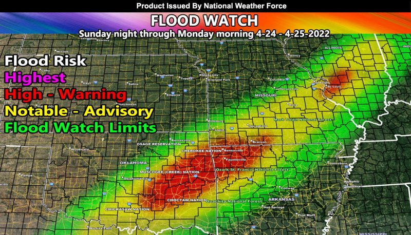
Issued or Partial Issued States: OK, AR, MO, IL – Map inside shows affected state areas.
Site: National Weather Force has issued a Flood Watch effective Sunday night through Monday morning …
Date: 4/22/22 at 6:50pm Central Time
Forecast: A stationary front from southwest to northeast, Northern Texas through to Indiana will be the focus point of showers and thunderstorms. The storms should be around even before the allotted time specified in this watch, however the peak of such activity will be Sunday night through Monday morning. Strong forcing along this front will bring high rainfall rates per hour.
The NWF Flood Risk Assessment Model clearly shows the Eastern half of Oklahoma and Northwest Arkansas being the major focus spot for this. No doubt in my mind the red (warning) will have flooding so you can do your flood preparations now, whatever it is you do. This will also focus on St. Louis, MO with the smaller area of ‘high’ (warning) in that area as well.
Storms are not expected to be severe as instability looks weak, but thunderstorms, embedded, will be possible …
HOW TO GET THESE ALERTS?.
SIGN-UP TO THE FREE NWF E-MAIL ALERT SYSTEM FOR YOUR AREA HERE WHERE YOU PICK YOUR AREA IN YOUR OWN CONTROL PANEL BY STATE LOCATION AND GET NOTIFIED WHEN A POST IS MADE FOR YOU https://www.nationalweatherforce.com/national-weather-force-email-alert-system-sign-up/
FOLLOW the Facebook Page after reading this and interact with the post made about this, whether sharing, liking, or commenting … It will be answered
CLICK HERE TO FOLLOW THE MAIN FACEBOOK PAGE

