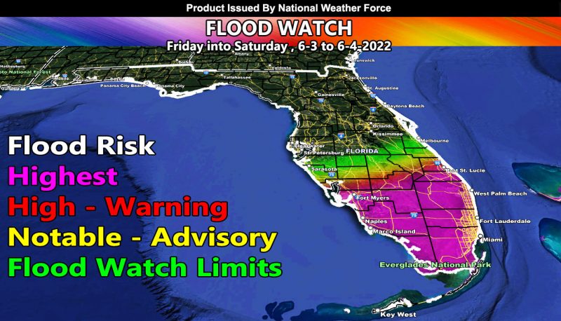
Issued or Partial Issued States: Southern Florida – Map inside shows affected state areas.
Site: National Weather Force has issued a Flood Watch effective Friday/Saturday 6-3 through 6-4-2022 for a tropical disturbance that could turn depression/storm …
Date: 6/2/22 at 12:10pm Eastern Time
Forecast: A tropical disturbance that will cross Southern Florida on Saturday will bring rainfall starting as early as Friday across the watch area. The main crossing will be Saturday, bringing a large area of flood dynamics.
There are things being monitored on this system, including the chance it closes up at the surface and becomes a Tropical Depression and/or a Tropical Storm, which would be the first named Atlantic Basin system this season. But for now, the broad elongated look to it as it crosses will maintain a highest risk flood zone on the in-office model here, which is the image in this post.
This will be common this season as I expect a very active season in this basin …
Some areas in the watch zones will see over 8-10+” of rainfall in this short period of time. Waterspouts/Thunderstorms will also be possible and some may landfall as tornadoes …
A NWF Flood Watch means conditions are possible for heavy rainfall in a short period of time that can lead to flooding in spots. Hydroplaning on roadways is very likely in this type of scenario as well.
HOW TO GET THESE ALERTS?.
SIGN-UP TO THE FREE NWF E-MAIL ALERT SYSTEM FOR YOUR AREA HERE WHERE YOU PICK YOUR AREA IN YOUR OWN CONTROL PANEL BY STATE LOCATION AND GET NOTIFIED WHEN A POST IS MADE FOR YOU https://www.nationalweatherforce.com/national-weather-force-email-alert-system-sign-up/
FOLLOW the Facebook Page after reading this and interact with the post made about this, whether sharing, liking, or commenting … It will be answered
CLICK HERE TO FOLLOW THE MAIN FACEBOOK PAGE

