
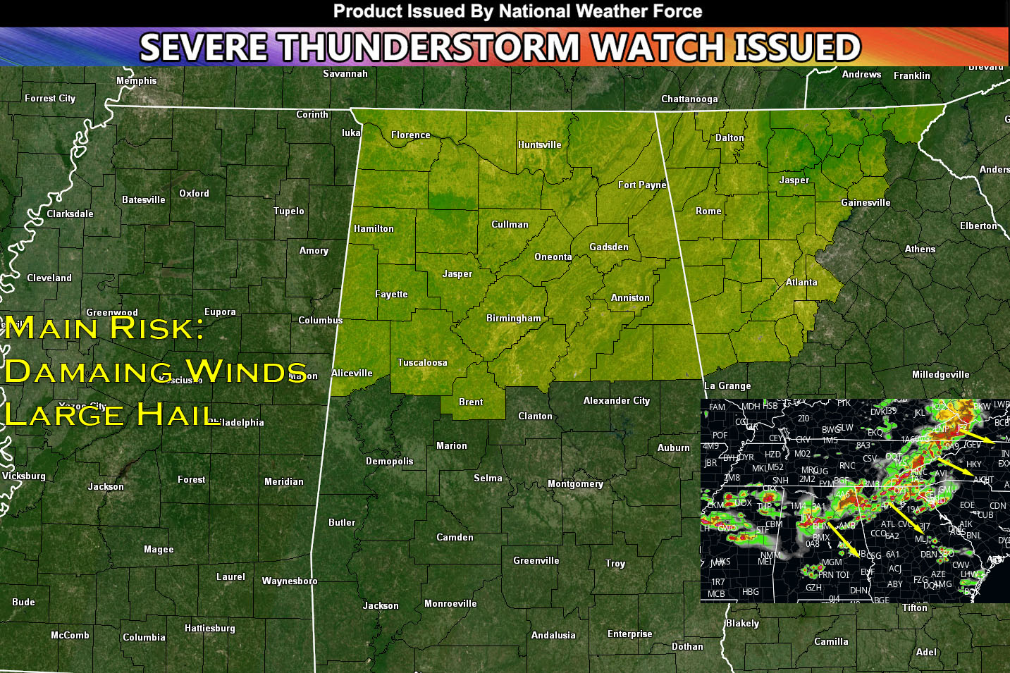
National Weather Force has issued a Severe Thunderstorm Watch/Outlook effective this evening and going until 1am EDT Monday Morning for Northcentral Alabama & Northcentral Georgia.
A large line of severe storms has been spotted all across the North with many reports of damaging winds and large hail all across Tennessee. These storms are expected to keep strength and move southeast into Alabama and Georgia later tonight and through early tomorrow morning. More convective activity is also possible along outflow boundaries creating pop ups. Strongest storms will be capable of producing damaging winds and large hail. Due to limited low-level shear there the tornado risk is very low. These storms will diminish in strength as they move out of the favorable environment to the south and east of the area.
Stay tuned for more updates.
End Article –
——————————
SIGN-UP TO THE FREE NWF E-MAIL ALERT SYSTEM FOR YOUR AREA HERE WHERE YOU PICK YOUR AREA IN YOUR OWN CONTROL PANEL BY STATE LOCATION AND GET NOTIFIED WHEN A POST IS MADE FOR YOU – https://www.nationalweatherforce.com/national-weather…/
WHAT IS NWF? ? ? ? This page/site is a custom weather forecast office for higher class events. Whether tornado, flood, winter, hurricane, or long-range issuance, the alert system works for your area. There are times you will see things here not posted elsewhere, or not at all.
The forecasts here are not developed by outside sources and is a full stacked private weather office for the nation, the first of its kind in issuing weather watches/advisories to the people in a private forum …
All you have to do is like/follow and the newsfeed will target your area. Oh, and get on the free e-mail alert system, you’ll be glad you did. Information is in the comment sections in alerts that matter the most to you, your family, or your friends – …
Sina⚡⚡
A forecaster with over 10+ years of experience in forecasting severe thunderstorms. Completely self taught in severe weather forecasting and computer science with a foundation from UNCO in Atmospheric Science. Moreover, he has been developing new tools to increase the chances of accurately forecasting large hail and tornadoes. A big contributor of National Weather Force bringing accuracy, timely information, and tools for keeping those impacted informed.
NOTE: Alerts are posted on here, be it a tornado watch, etc, and these alerts are issued from this office and nowhere else. At times, which is often, you will see an alert forecast posted on here that you do not see elsewhere. That is fine, the track record of the main office is very high so maintain to follow an event when posted.