
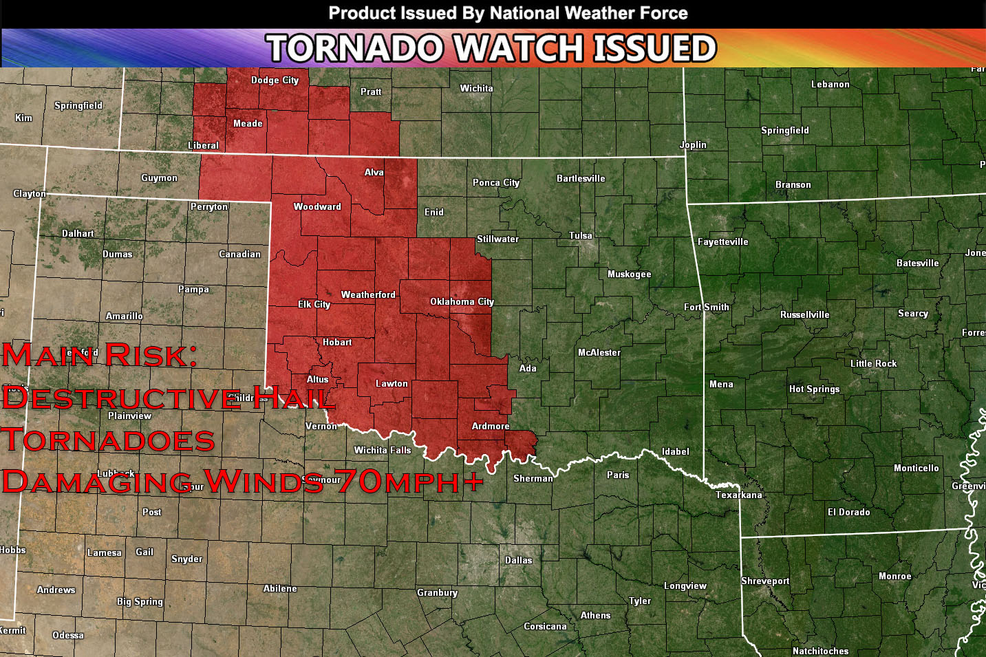
National Weather Force has issued a Tornado Watch/Outlook effective this evening and going until 10pm CDT for southwestern Kansas & western Oklahoma.
A shortwave trough is expected to approach the area from the southwest. As it approaches the central plains, it will deepen and meet low-level moisture ahead of a sharpening dryline (that is moving slowly east). This combined with very high levels of instability will bring a risk for destructive hail and damaging winds in excess of 75+ mph. Moreover, there will be deep layer shear that will support super-cellular storms. This combined with some low level-shear will also bring a tornado risk especially for Western Oklahoma. These storms will form around 4pm CDT and move eastward with time. The best given time for tornadoes looks to be around sunset for western Oklahoma where the low-level shear will maximize temporarily. These storms will become more linear overnight with the main risk being damaging winds. Storms will dissipate once they move out of the favorable environment area east of the watch.
Stay tuned for more updates.
End Article –
——————————
SIGN-UP TO THE FREE NWF E-MAIL ALERT SYSTEM FOR YOUR AREA HERE WHERE YOU PICK YOUR AREA IN YOUR OWN CONTROL PANEL BY STATE LOCATION AND GET NOTIFIED WHEN A POST IS MADE FOR YOU – https://www.nationalweatherforce.com/national-weather…/
WHAT IS NWF? ? ? ? This page/site is a custom weather forecast office for higher class events. Whether tornado, flood, winter, hurricane, or long-range issuance, the alert system works for your area. There are times you will see things here not posted elsewhere, or not at all.
The forecasts here are not developed by outside sources and is a full stacked private weather office for the nation, the first of its kind in issuing weather watches/advisories to the people in a private forum …
All you have to do is like/follow and the newsfeed will target your area. Oh, and get on the free e-mail alert system, you’ll be glad you did. Information is in the comment sections in alerts that matter the most to you, your family, or your friends – …
Sina⚡⚡
A forecaster with over 10+ years of experience in forecasting severe thunderstorms. Completely self taught in severe weather forecasting and computer science with a foundation from UNCO in Atmospheric Science. Moreover, he has been developing new tools to increase the chances of accurately forecasting large hail and tornadoes. A big contributor of National Weather Force bringing accuracy, timely information, and tools for keeping those impacted informed.
NOTE: Alerts are posted on here, be it a tornado watch, etc, and these alerts are issued from this office and nowhere else. At times, which is often, you will see an alert forecast posted on here that you do not see elsewhere. That is fine, the track record of the main office is very high so maintain to follow an event when posted.