
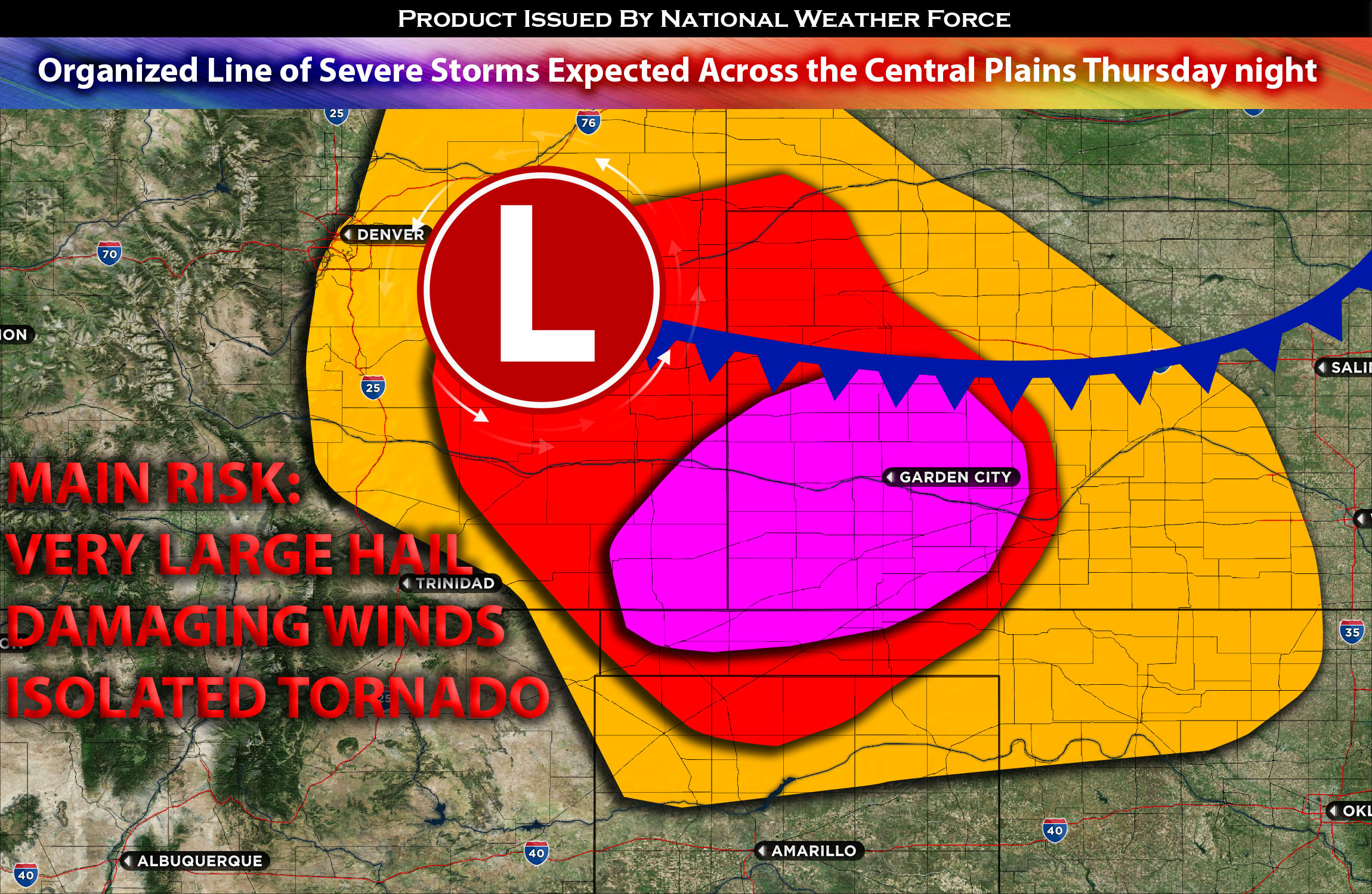
As the cold front progresses southeastward and stalls around the mid Colorado area, coupled with abundant moisture and significant instability, thunderstorms are expected to develop in the afternoon, primarily starting in the Colorado mountain range. These storms will encounter elevated mid-level shear, leading to the formation of severe thunderstorms capable of producing large to very large hail, particularly in eastern Colorado and southeastward into the affected regions. There will also be a risk for isolated tornadoes given the low-level jet slightly strengthening in a small-time frame during the evening across the southeastern CO area.
Later in the evening, these thunderstorms will converge and form a Mesoscale Convective System (MCS), which will continue to organize and move southeastward into portions of the Texas/Oklahoma Panhandle and southwestern Kansas. This MCS is anticipated to maintain its southeastward trajectory, impacting areas of southern Kansas and northern Oklahoma. The primary risk associated with these storms will be damaging straight-line winds.
As the line of storms progresses through the Oklahoma/Kansas border, it is expected to weaken, primarily resulting in heavy rainfall over the remaining areas as it moves eastward during Friday morning.
Main risk: Large to very large hail, damaging winds, and isolated tornadoes.
Timing: Storms are expected to form around 1-2pm MDT in CO area and move east southeastward then finally organizing into a line around the evening into overnight across the TX/OK panhandle and into portions of KS/OK into the morning hours of Friday.
Stay tuned for more updates.
Sina⚡⚡
With over a decade of experience in forecasting severe thunderstorms, this individual is a seasoned forecaster and developer. Their expertise in severe weather forecasting and computer science is entirely self-taught, complemented by a foundation in Atmospheric Science from UNCO. They have dedicated their efforts to developing innovative tools that enhance the accuracy of analyzing large hail and tornadoes. As a significant contributor to the National Weather Force, they have played a crucial role in providing accurate and timely information, as well as developing tools to keep those affected well-informed.
NOTE: The alerts and outlooks posted here are customary made to inform. At times, which is often, you will see an alert forecast posted on here that you do not see elsewhere. That is fine, the track record of the main office is very high so maintain to follow an event when posted. These are custom concentrated alerts and outlooks that are created by National Weather Force team of experts. They do not intend to represent the NWS or SPC.