
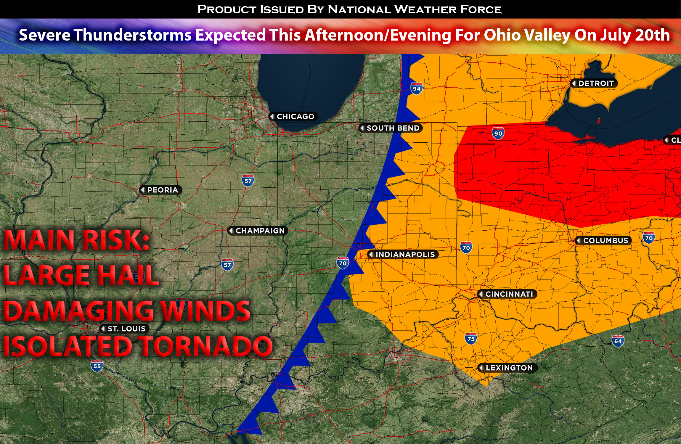
An advancing cold front will move across Indiana and Ohio. Plenty of moisture and lift (created by the front) will bring favorable conditions for the development of thunderstorms across the area. Furthermore, the atmosphere will have moderate to locally strong westerly winds at higher altitudes, known as effective shear, exceeding 40 knots in certain areas across Ohio area.
As a result, supercell thunderstorms are possible and likely to have the potential to produce large hail, particularly in southern Lower Michigan, northern Indiana, and Ohio. As the storms progress, they may merge and form a more organized system during the late afternoon or early evening, known as storm mergers or upscale growth. With the intensification and growth of the storms, there will be an increased risk of damaging winds. The merging and strengthening of the storms can amplify the potential for destructive winds, posing a threat to the affected regions. Additionally, there is a possibility of tornadoes forming within this dynamic atmospheric environment given the elevated low-level shear.
Main risk: large hail, isolated tornado, damaging straight-line winds, local flooding given heavy rainfall.
Timing: A couple rounds of severe storms are expected given the unstable atmosphere. Severe storms can start to form as soon as early afternoon across the area and more organized ones will continue to form across Michigan, Ohio, Indiana area. Later in the evening, these storms will combine and become a line of organized storms with mainly straight-line wind expected to the impacted regions.
Stay tuned for more updates.
Sina⚡⚡
With over a decade of experience in forecasting severe thunderstorms, this individual is a seasoned forecaster and developer. Their expertise in severe weather forecasting and computer science is entirely self-taught, complemented by a foundation in Atmospheric Science from UNCO. They have dedicated their efforts to developing innovative tools that enhance the accuracy of analyzing large hail and tornadoes. As a significant contributor to the National Weather Force, they have played a crucial role in providing accurate and timely information, as well as developing tools to keep those affected well-informed.
NOTE: The alerts and outlooks posted here are customary made to inform. At times, which is often, you will see an alert forecast posted on here that you do not see elsewhere. That is fine, the track record of the main office is very high so maintain to follow an event when posted. These are custom concentrated alerts and outlooks that are created by National Weather Force team of experts. They do not intend to represent the NWS or SPC.