
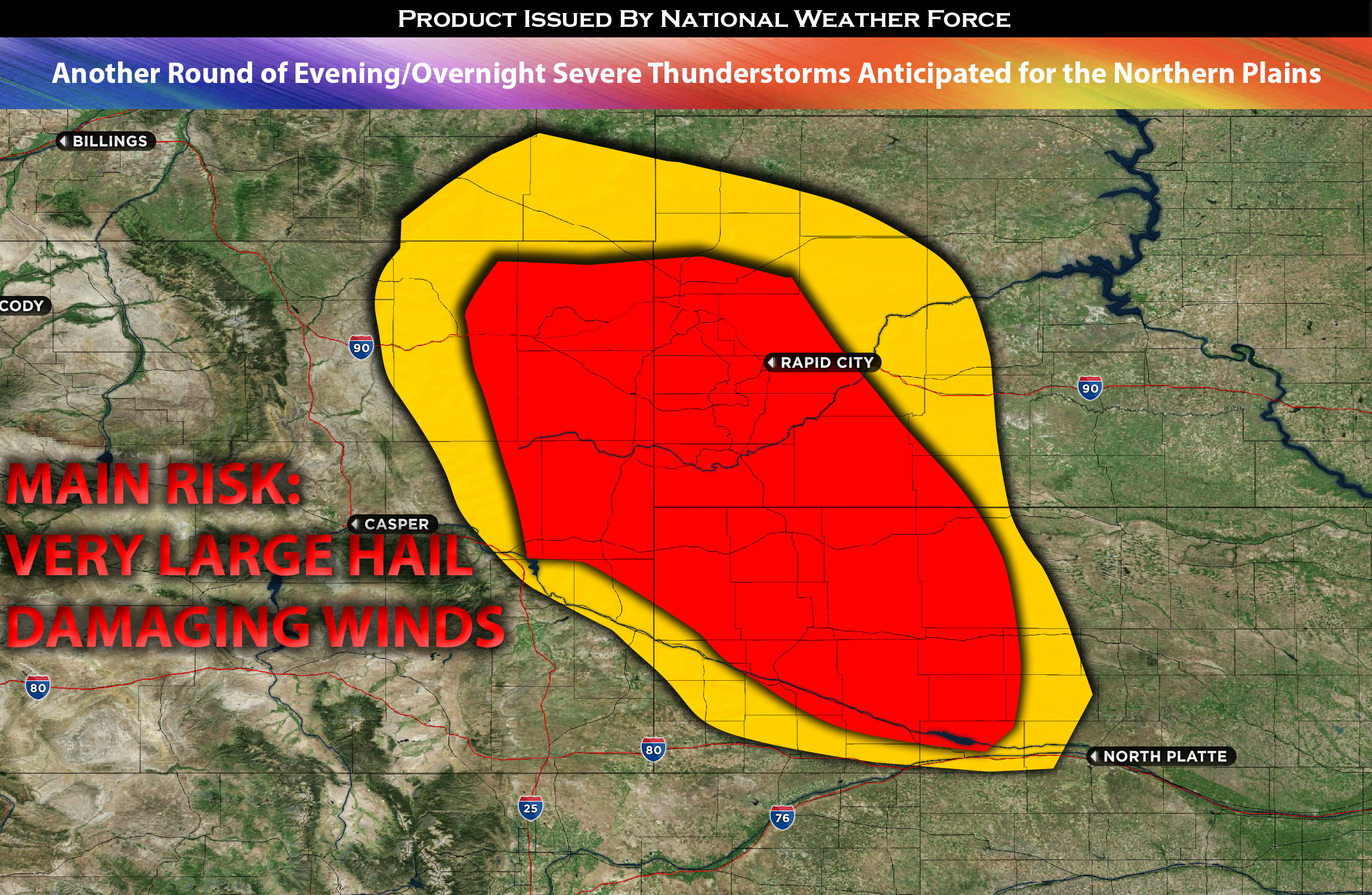
The northern Plains and neighboring states are in for more rounds of severe storms as we head into this evening and overnight. A boundary is expected to set up, leading to further frontogenesis along southern North Dakota into northern South Dakota, along the eastern edge of a zone with steeper temperature differences with height.
The prevailing conditions in the area include a moist and unstable airmass, which is typical for this seasonal time. Additionally, there is much steeper effective mid-level shear anticipated around this region, combined with elevated instability. These factors create an environment conducive to the development of severe thunderstorms.
These storms are likely to be capable of producing very large hail and straight-line winds. The initial formation is expected in the southwestern South Dakota and northeastern Wyoming area. As they progress east southeastward, they are likely to strengthen, eventually organizing into a linear structure overnight into portions of NE and eastern SD.
The most severe activity is projected to occur around Northeastern Wyoming and western South Dakota, where the effective bulk shear maximizes within a short timeframe. This concentration of shear may result in very large hail accompanying the severe storms in this region.
Main risk: very large hail, damaging straight-line winds, tornado possible but not likely.
Timing: Evening and mainly over-night from west to east across South Dakota and NE area.
Stay tuned for more updates.
Sina⚡⚡
With over a decade of experience in forecasting severe thunderstorms, this individual is a seasoned forecaster and developer. Their expertise in severe weather forecasting and computer science is entirely self-taught, complemented by a foundation in Atmospheric Science from UNCO. They have dedicated their efforts to developing innovative tools that enhance the accuracy of analyzing large hail and tornadoes. As a significant contributor to the National Weather Force, they have played a crucial role in providing accurate and timely information, as well as developing tools to keep those affected well-informed.
NOTE: The alerts and outlooks posted here are customary made to inform. At times, which is often, you will see an alert forecast posted on here that you do not see elsewhere. That is fine, the track record of the main office is very high so maintain to follow an event when posted. These are custom concentrated alerts and outlooks that are created by National Weather Force team of experts.