
We’re already observing some showers and thunderstorm activity this morning in certain areas of Missouri. Nonetheless, a more systematic event is expected to transpire later today. An MCV (mesoscale convective vortex) over north-central Kansas, along with remnants of an MCS (an organized line of convective storms), is anticipated to drift eastward into northern Missouri this afternoon.
Coupled with a considerably more unstable air mass over Missouri, this will trigger an intensification of convective activity, initially in the north/northwestern parts of Missouri and then followed by the central region where the key components are most concentrated.
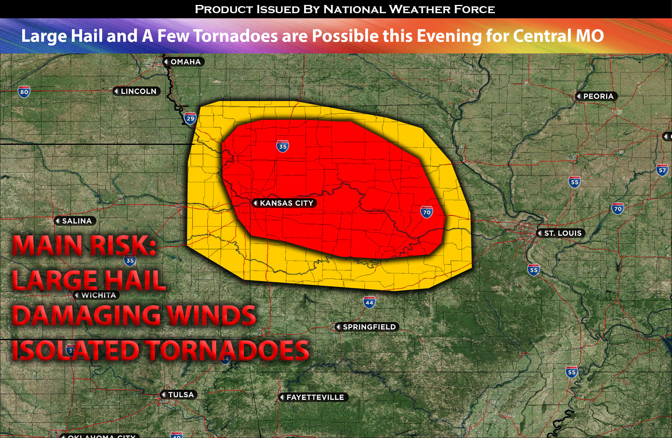
As the MCV and residual outflow cold pool progress into Missouri, the confluence of moderate to strong instability, ample low-level moisture, and mid-level shear will enable the development of severe storms across the region. These storms could produce large, potentially very large hail, and damaging winds.
Due to the spiral nature of the MCV, some of these storms will witness a significant increase in vertical shear for a brief period later this evening, primarily in central Missouri. This will heighten the risk of tornadoes in that region.
Following this, the storms are predicted to become more linear, or bow out, and subsequently decrease in intensity as they move into eastern Missouri.
Main risk: large hail, damaging straight-line winds and a few tornadoes are possible.
Timing: Storms are expected to form around 3-5pm CDT across northwestern MO and continue to move eastward. Then more explosive activity is expected in central MO separate which will be the most concentrated location for severe weather. These storms will become more linear as they progress eastward before diminishing overnight. Don’t be surprised for any pop of storms from remnant outflow boundaries as well in eastern/central MO.
Locations Impacted: northwest MO, central MO, eastern MO, and northern MO.
Stay tuned for more updates.
Sina⚡⚡
With over a decade of experience in forecasting severe thunderstorms, this individual is a seasoned forecaster and developer. Their expertise in severe weather forecasting and computer science is entirely self-taught, complemented by a foundation in Atmospheric Science from UNCO. They have dedicated their efforts to developing innovative tools that enhance the accuracy of analyzing large hail and tornadoes. As a significant contributor to the National Weather Force, they have played a crucial role in providing accurate and timely information, as well as developing tools to keep those affected well-informed.
NOTE: The alerts and outlooks posted here are customary made to inform. At times, which is often, you will see an alert forecast posted on here that you do not see elsewhere. That is fine, the track record of the main office is very high so maintain to follow an event when posted. These are custom concentrated alerts and outlooks that are created by National Weather Force team of experts.