
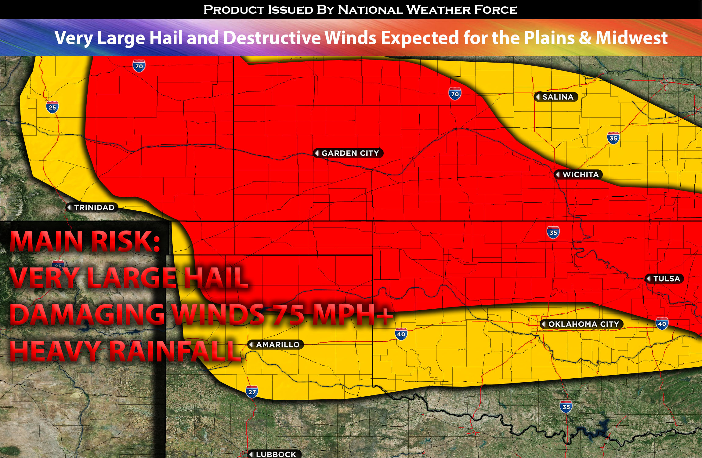
A sizable region spanning the southern to central Plains is anticipated to experience severe thunderstorms. Early signs of convective activity, due to remnants of prior storms, are already visible around central Oklahoma, moving eastward. While these storms are predicted to lose strength and gradually fade as they reach eastern Oklahoma, sporadic activity is still expected.
In contrast, a more intense storm setup is forecasted for southeastern Colorado and the Texas panhandle. Here, moist upper airflows over upslope regions will generate thunderstorms. These will be boosted by locally high levels of instability and mid-level shear, further intensified by an upper-level jet moving into the central plains later in the day. As this unfolds, we can expect isolated supercell formations in southeast Colorado and the Texas panhandle. Such storms can yield very large hail, with some areas potentially facing hailstones larger than 3 inches in diameter.
Additionally, the Texas and Oklahoma panhandle, in particular, is at risk for significant wind damage, especially as the jet stream intensifies over this area. Some storms might generate gusts exceeding 75 mph, with even stronger gusts possible given the right conditions.
This mesoscale convective system (MCS) will then progress eastward, encompassing areas of Oklahoma and parts of western and southern Kansas, expanding in scale as the night progress into MO and AR. Nonetheless, given the potent mix of storm ingredients, it still poses a threat with potential for damaging winds, heavy downpours, and intense cloud-to-ground lightning continuing into the night.
Main risk: very large hail, damaging straight-line winds 75mph+ (locally higher) and local heavy rainfall.
Timing: Storms are expected to form in southeast and across CO around 2-3pm and strengthen as they move the east into eastern/southeastern CO. Then storms are expected to explode across the TX panhandle around 5-6pm and continue to sporadically strengthen before forming into and a MCS across OK/KS south overnight. For more detailed and times check the graphic below.
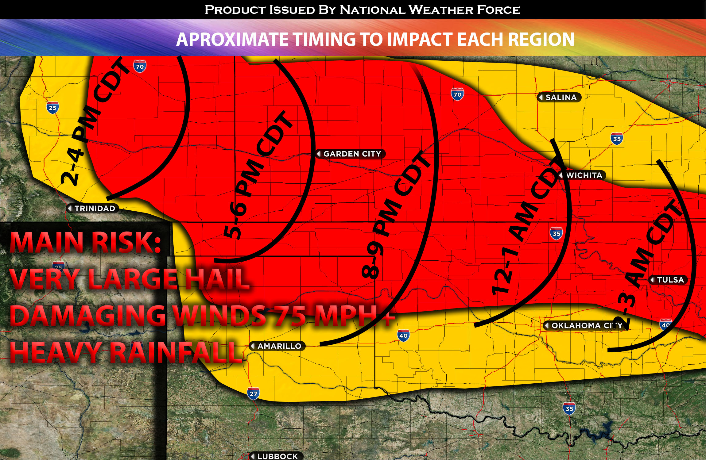
Locations Impacted: southeast and east CO, KS west and south (later overnight). Also, TX panhandle, OK panhandle, Oklahoma central and AR/MO overnight.
Stay tuned for more updates.
Sina⚡⚡
With over a decade of experience in forecasting severe thunderstorms, this individual is a seasoned forecaster and developer. Their expertise in severe weather forecasting and computer science is entirely self-taught, complemented by a foundation in Atmospheric Science from UNCO. They have dedicated their efforts to developing innovative tools that enhance the accuracy of analyzing large hail and tornadoes. As a significant contributor to the National Weather Force, they have played a crucial role in providing accurate and timely information, as well as developing tools to keep those affected well-informed.
NOTE: The alerts and outlooks posted here are customary made to inform. At times, which is often, you will see an alert forecast posted on here that you do not see elsewhere. That is fine, the track record of the main office is very high so maintain to follow an event when posted. These are custom concentrated alerts and outlooks that are created by National Weather Force team of experts.