
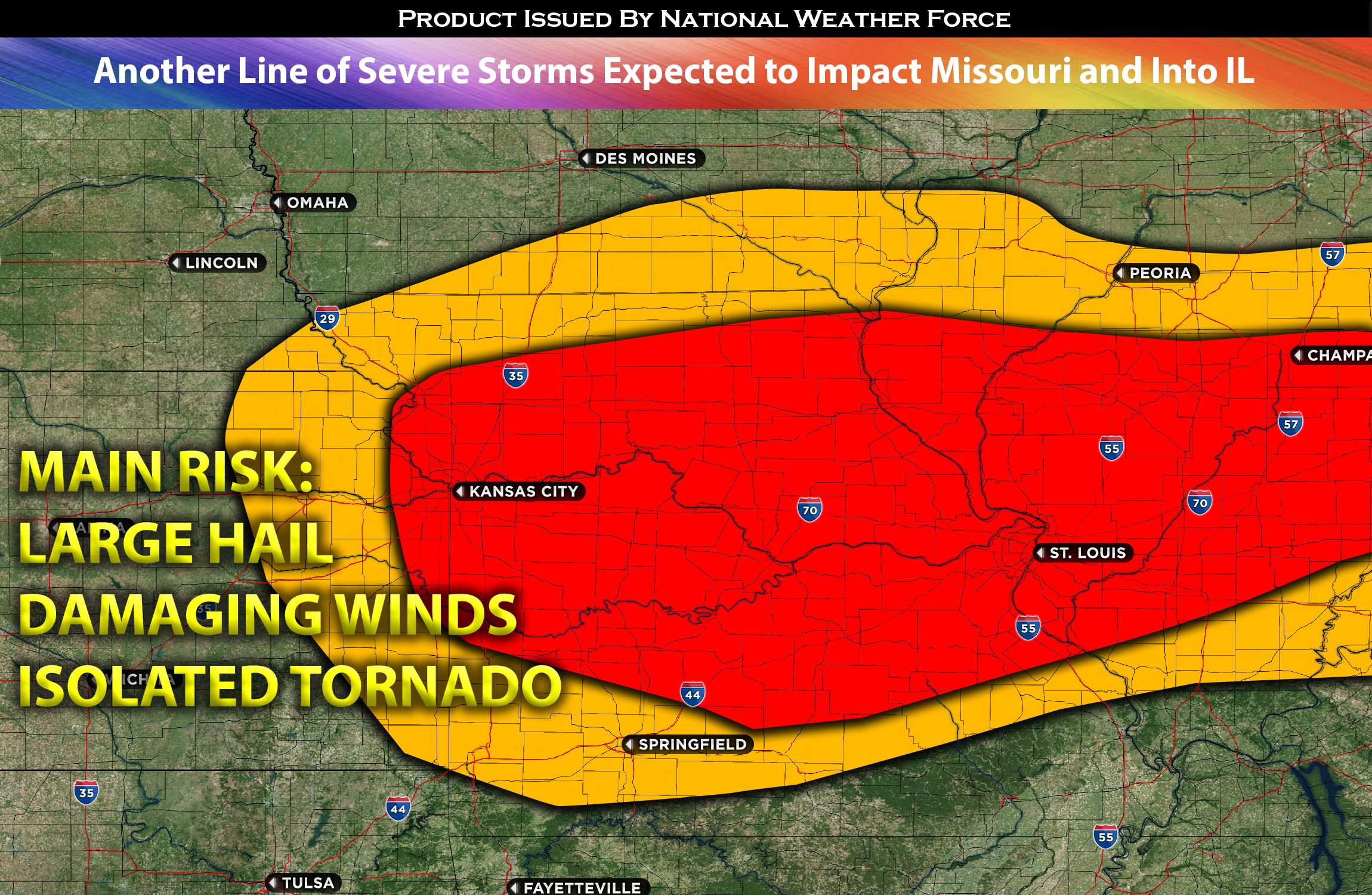
Forecast: Continuous thunderstorm activity, originating from the redevelopment of convection around an outflow boundary in MO from lingering storms, is expected for the afternoon and will persist into the evening. This is due to the storms lingering from earlier. Coupled with abundant low-level moisture, a strengthening low-level jet, and mid-level northwesterlies will create an unstable atmosphere for severe thunderstorms. These storms may produce large hail, damaging winds, and perhaps the occasional isolated tornado. Storms are anticipated to form in the evening and last into the overnight hours of Friday, beginning from far eastern KS, northwestern MO and extending into parts of IA. As they progress, they’ll move southeast across MO.These severe storms will cluster and traverse MO, with some affecting central and southern IL, moving from northwest to southeast. As night falls, these storm clusters are expected to bow out, sweeping across most of MO with the primary threat being damaging straight-line winds. The intensity of these storms will wane rapidly as they approach the MO/AR borders. By the morning hours of Saturday, the remnants will mainly be heavy rain and sporadic thunderstorms.
Main risk: large hail, damaging straight-line winds, and perhaps an occasional isolated tornado (possible but not a main threat due to lack of low-level shear).
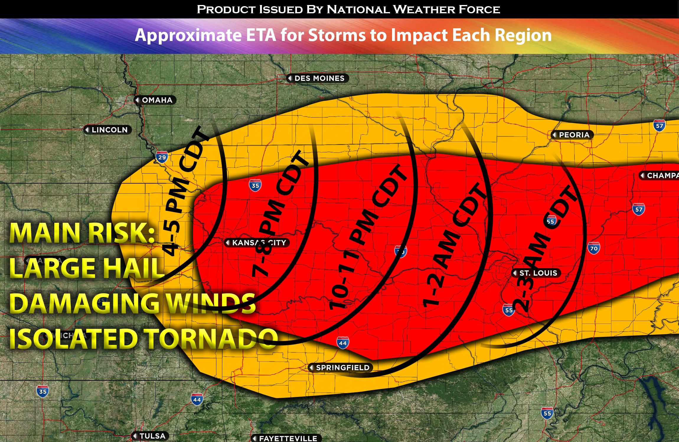
Timing: Storms are expected to form in the evening and last into the overnight hours of Friday, beginning from northwestern MO and extending into parts of IA. As they progress, they’ll move southeast across MO. These severe storms will cluster and traverse MO, with some affecting central and southern IL, moving from northwest to southeast. For more detailed ETA check the graphic below for details on approximate timing.
Locations Impacted: IA southwest, south; MO northwest, north, central, southwest, southeast, east; and IL west, central and potentially lingering into east IL.
Stay tuned for more updates.
Sina⚡⚡
With over a decade of experience in forecasting severe thunderstorms, this individual is a seasoned forecaster and developer. Their expertise in severe weather forecasting and computer science is entirely self-taught, complemented by a foundation in Atmospheric Science from UNCO. They have dedicated their efforts to developing innovative tools that enhance the accuracy of analyzing large hail and tornadoes. As a significant contributor to the National Weather Force, they have played a crucial role in providing accurate and timely information, as well as developing tools to keep those affected well-informed.
NOTE: The alerts and outlooks posted here are customary made to inform. At times, which is often, you will see an alert forecast posted on here that you do not see elsewhere. That is fine, the track record of the main office is very high so maintain to follow an event when posted. These are custom concentrated alerts and outlooks that are created by National Weather Force team of experts.