
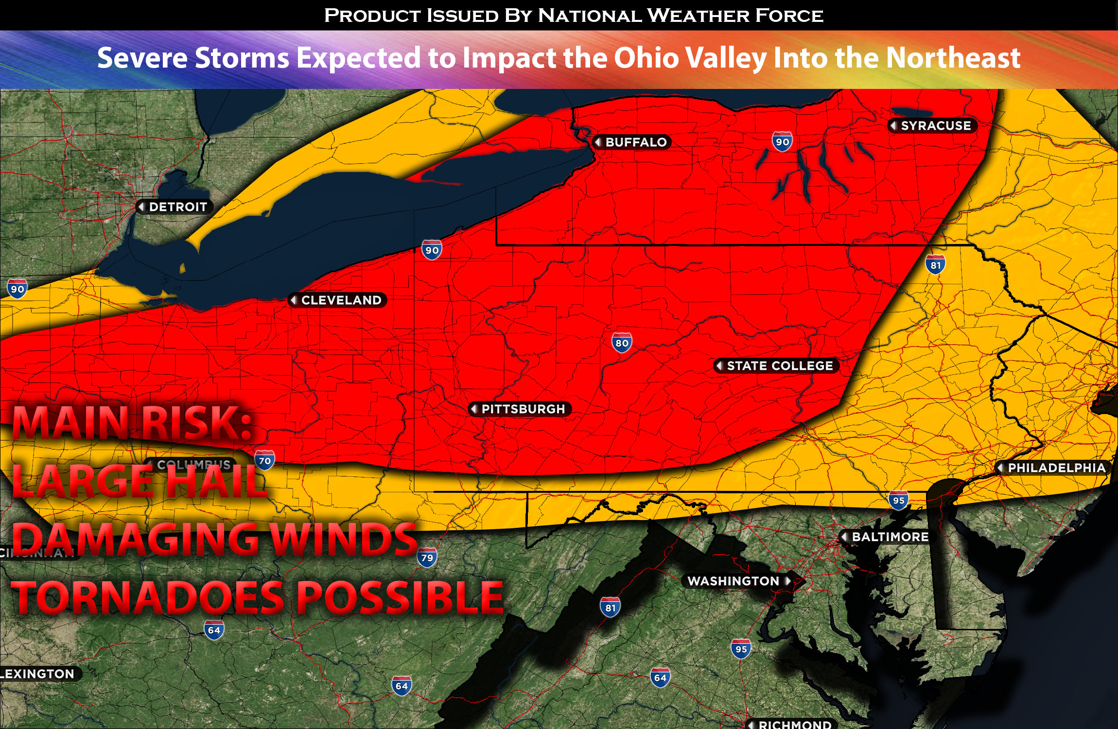
For Ohio Valley:
Scattered severe thunderstorms are expected to form across portions of the Ohio Valley, extending eastward into the afternoon and evening. This will occur as a surface low strengthens and moves in conjunction with a cold front that’s anticipated to sweep through the Ohio area. The presence of warm, moist air in the low levels and ample instability will facilitate the formation of these storms. Initially, the primary threats from these storms will be large hail and damaging winds.
For Northeast Specifically NY and PA:
However, as the storms progress further east into the western NY and PA areas, a more concentrated setup will take shape. Daytime heating and moist advection ahead of the storms will enhance the atmospheric lift (or buoyancy) in these regions. Additionally, the presence of an offset vertical boundary might further increase moisture content in the area. When combined with increased instability and a mix of mid-level and low-level vertical shear, there’s also a heightened risk for tornadoes, especially across western NY and PA. That said, the window for potential tornadoes is limited, and if any do occur, it’s likely to be during the evening. Given these conditions, there’s also an increased risk for very large hail, particularly with more organized storm cells. As these severe storms continue their eastward trek across NY, they’ll weaken significantly upon nearing the eastern part of the state. Throughout the night, the main threats in these areas will remain as hail, localized strong winds, and cloud-to-ground (CG) lightning.
Main risk: large hail, damaging straight-line winds, and perhaps an occasional isolated tornado (possible due to plenty of vertical shear over western NY and PA).
Timing: Storms are expected to form across Ohio in the afternoon around 12pm-1pm EDT mostly northern and eastern portion of Ohio (scattered in nature). Given that, more storms can form anywhere in Ohio with the right ingredients. As they continue to the east across NY they will continue to go through spontaneous strengthening and become more widespread across NY around late evening and into the overnight hours before impacting the rest of the region into NY and PA overnight. These storms are then expected to lose strength and reach New York City 1-2am EDT (approximately).
Locations Impacted: Ohio mostly to the east and north (scattered in nature), NY west and mostly severe to the west mainly less likely still possible to the east. PA south, central and eventually to the east (less severe).
Stay tuned for more updates.
Sina⚡⚡
With over a decade of experience in forecasting severe thunderstorms, this individual is a seasoned forecaster and developer. Their expertise in severe weather forecasting and computer science is entirely self-taught, complemented by a foundation in Atmospheric Science from UNCO. They have dedicated their efforts to developing innovative tools that enhance the accuracy of analyzing large hail and tornadoes. As a significant contributor to the National Weather Force, they have played a crucial role in providing accurate and timely information, as well as developing tools to keep those affected well-informed.
NOTE: The alerts and outlooks posted here are customary made to inform. At times, which is often, you will see an alert forecast posted on here that you do not see elsewhere. That is fine, the track record of the main office is very high so maintain to follow an event when posted. These are custom concentrated alerts and outlooks that are created by National Weather Force team of experts.