
Scattered thunderstorms are expected to form over the higher terrains of CO and NM, as well as the plains of the northern TX panhandle and northeastern NM. Strong heating will lift the low-level moisture off the mountains, which when combined with existing moisture, will rapidly weaken the atmospheric cap over the area. As the evening progresses, these storms are set to intensify when they encounter a well-mixed deep boundary layer. This will coincide with a deep cool pool surging into the highly unstable air mass, characterized by elevated levels of ML instability and mid-layer shear.
As these storms escalate in severity, they are likely to cluster together, forming a storm line that will traverse southeastern CO, extend through the northern TX panhandle, and proceed into KS overnight. However, as these storms shift eastward, they will encounter a more stable airmass to the eastern part of KS/OK, causing them to diminish in intensity as they progress through there. The timing remains uncertain due to the unpredictability of cool pools and where the cap might weaken over the KS area. Regardless, intense thunderstorms are expected to sweep across KS overnight, with the most severe storms concentrated further to the west and central KS. These storms will be capable of producing damaging straight-line winds and local heavy rainfall.
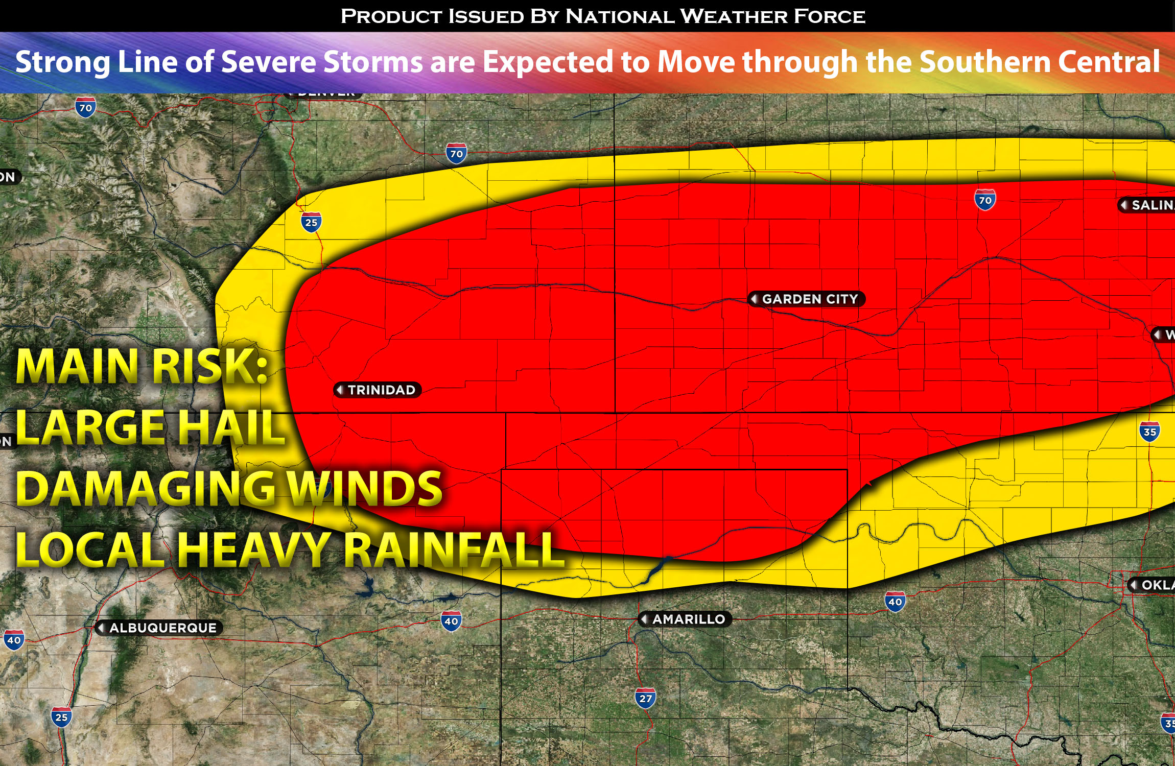
Main risk: large hail, damaging straight-line winds and local heavy rainfall.
Timing: Storms are expected to form across the Plains around the noon and continue to increase in coverage around 1-3pm CDT. The most severe activity seems to be around 3-5pm CDT given the concentrated area of ingredients especially in northern TX panhandle, southeast CO and southwestern/western KS. Then overnight around 12-3am CDT across the rest of KS and portions of norther OK area.
Locations Impacted: NM northeast, TX panhandle, CO southeast, KS west and central, OK north, and panhandle.
Stay tuned for more updates.
NOTE: This is a free trial until end of 2023.
Sina⚡⚡
With over a decade of experience in forecasting severe thunderstorms, this individual is a seasoned forecaster and developer. Their expertise in severe weather forecasting and computer science is entirely self-taught, complemented by a foundation in Atmospheric Science from UNCO. They have dedicated their efforts to developing innovative tools that enhance the accuracy of analyzing large hail and tornadoes. As a significant contributor to the National Weather Force, they have played a crucial role in providing accurate and timely information, as well as developing tools to keep those affected well-informed.
NOTE: The alerts and outlooks posted here are customary made to inform. At times, which is often, you will see an alert forecast posted on here that you do not see elsewhere. That is fine, the track record of the main office is very high so maintain to follow an event when posted. These are custom concentrated alerts and outlooks that are created by National Weather Force team of experts.