
Morning/Noon convective activity (not severe):
Lingering showers and thunderstorms are rapidly moving out of the area, with the main risks being local heavy rainfall, strong winds, and cloud-to-ground (CG) lightning. These storms are expected to exit the area, especially to the southwest and south, by late this afternoon.
Evening/Sunset Concentrated Severe Storms:
With warm air advection over central MO and an approaching cold front, coupled with anticipated clearing in the central and especially southern MO area, rapid destabilization is expected during peak heating. This will enable the formation of thunderstorms in multiple zones of western MO, southeastern MO, and southeastern/eastern portions of KS. These storms are predicted to intensify significantly as they progress eastward into MO.
Strong winds aloft will promote supercell development, and with high mid-level shear values, severe storms are likely to erupt across the southern and eastern parts of KS, extending into MO. As these storms move further eastward into MO, they could produce very large hail and potentially destructive straight-line winds due to the prevalent instability and downstream intensification. There will also be a tornado risk in southwestern portion (small time frame) given the vertical shear and potential spin in the hodographs. These storms are expected to evolve into an organized line of severe storms across MO, extending westward into KY, before they weaken in response to a less unstable atmosphere. Subsequently, the primary concerns will shift to very heavy rainfall and localized strong winds, persisting through the overnight and early morning hours in western KY and the southern regions of IL.
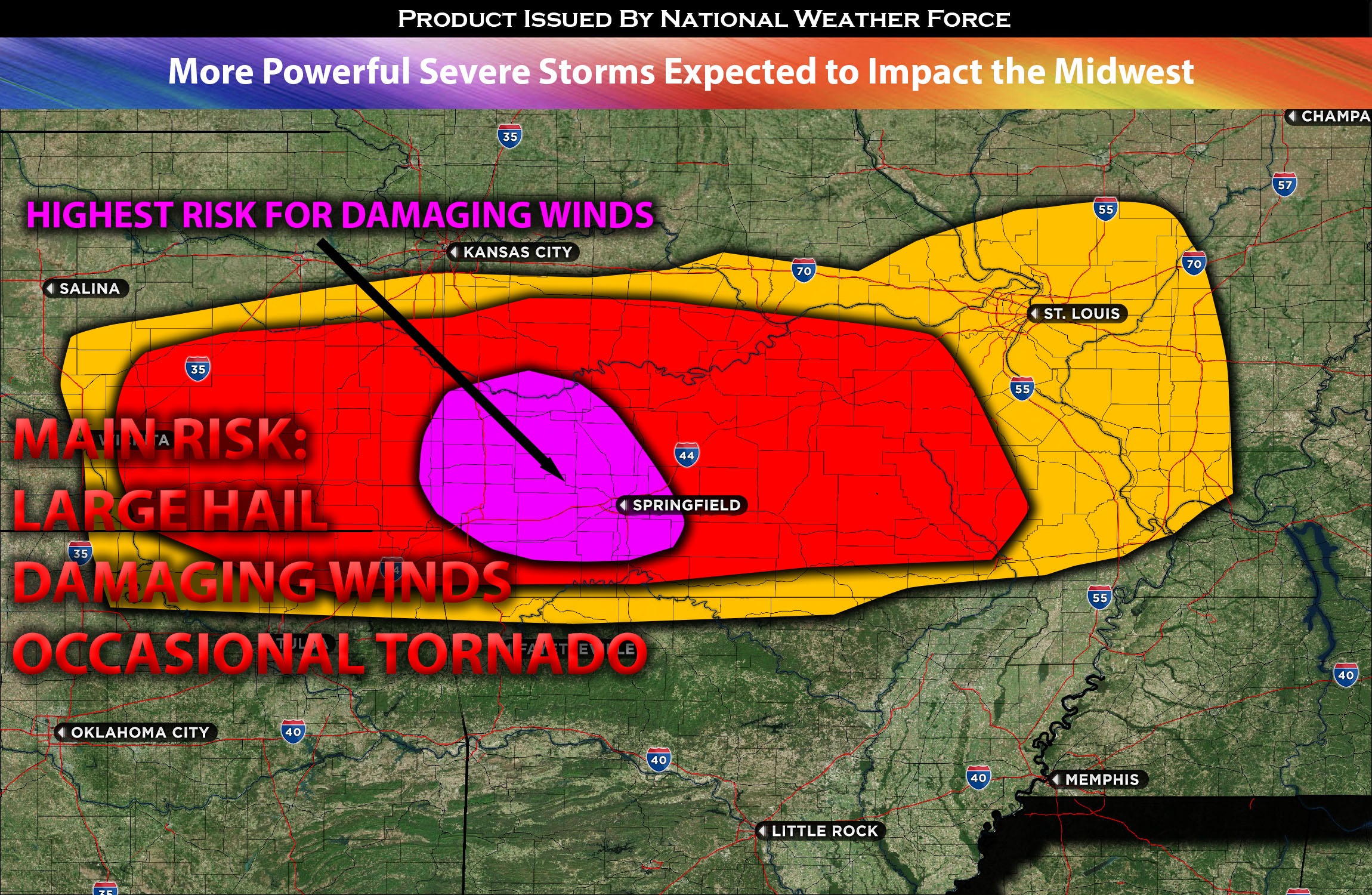
Main risk: very large hail, damaging straight-line winds, and perhaps an occasional tornado (possible due to plenty of vertical shear over MO and southeastern KS).
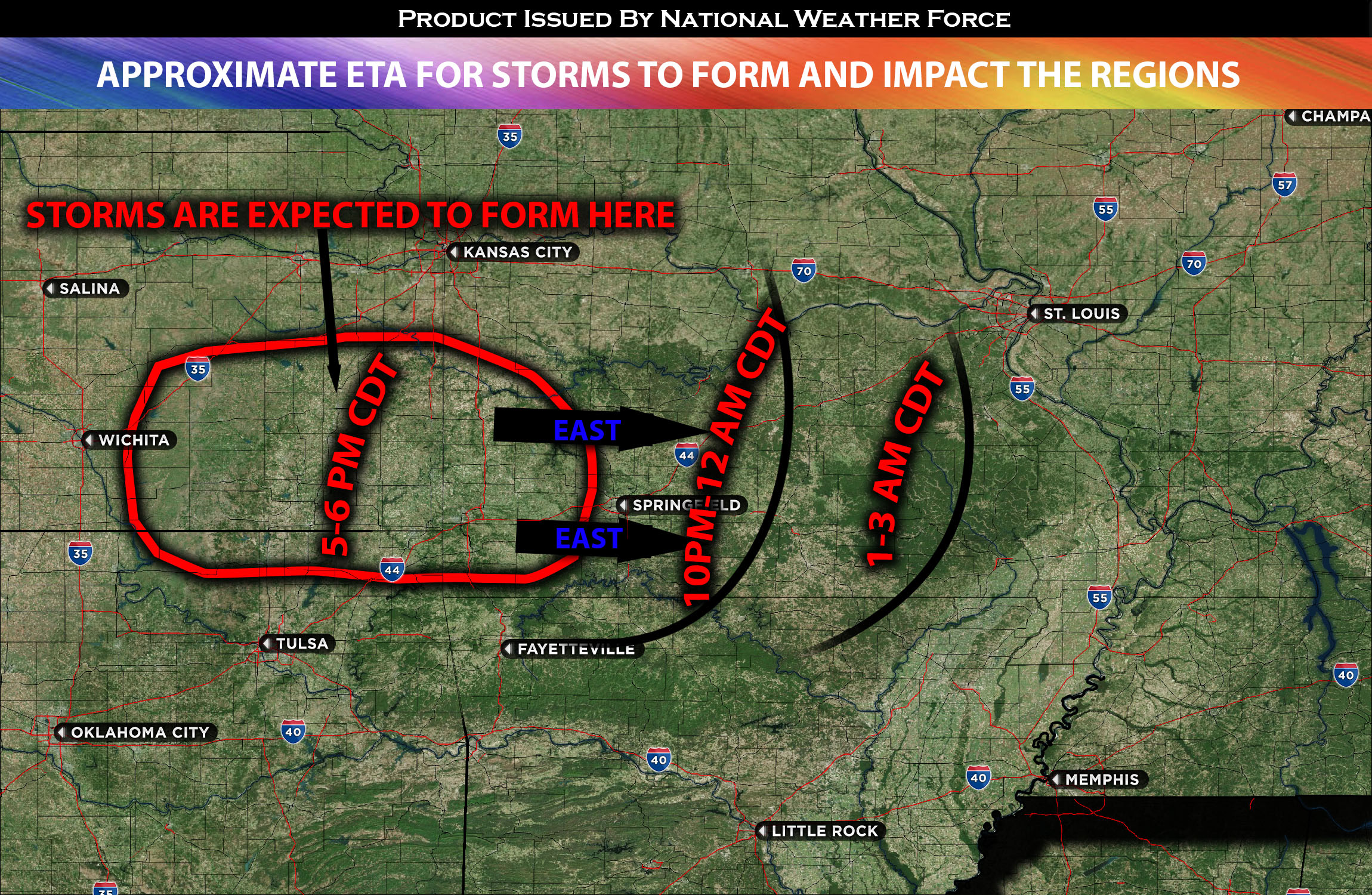
Timing: These severe storms are expected to form in eastern KS and into MO southwest/west around 5-6pm CDT and continue eastward through the rest of MO (half of MO downward). For more detailed ETA check the graphic below for where and when storms potentially can form.
Locations Impacted: KS southeast/east, MO central, southwest, south and southeast. The further north the more likely just heavy rain and CG lightning.
Stay tuned for more updates.
Sina⚡⚡
With over a decade of experience in forecasting severe thunderstorms, this individual is a seasoned forecaster and developer. Their expertise in severe weather forecasting and computer science is entirely self-taught, complemented by a foundation in Atmospheric Science from UNCO. They have dedicated their efforts to developing innovative tools that enhance the accuracy of analyzing large hail and tornadoes. As a significant contributor to the National Weather Force, they have played a crucial role in providing accurate and timely information, as well as developing tools to keep those affected well-informed.
NOTE: The alerts and outlooks posted here are customary made to inform. At times, which is often, you will see an alert forecast posted on here that you do not see elsewhere. That is fine, the track record of the main office is very high so maintain to follow an event when posted. These are custom concentrated alerts and outlooks that are created by National Weather Force team of experts.