
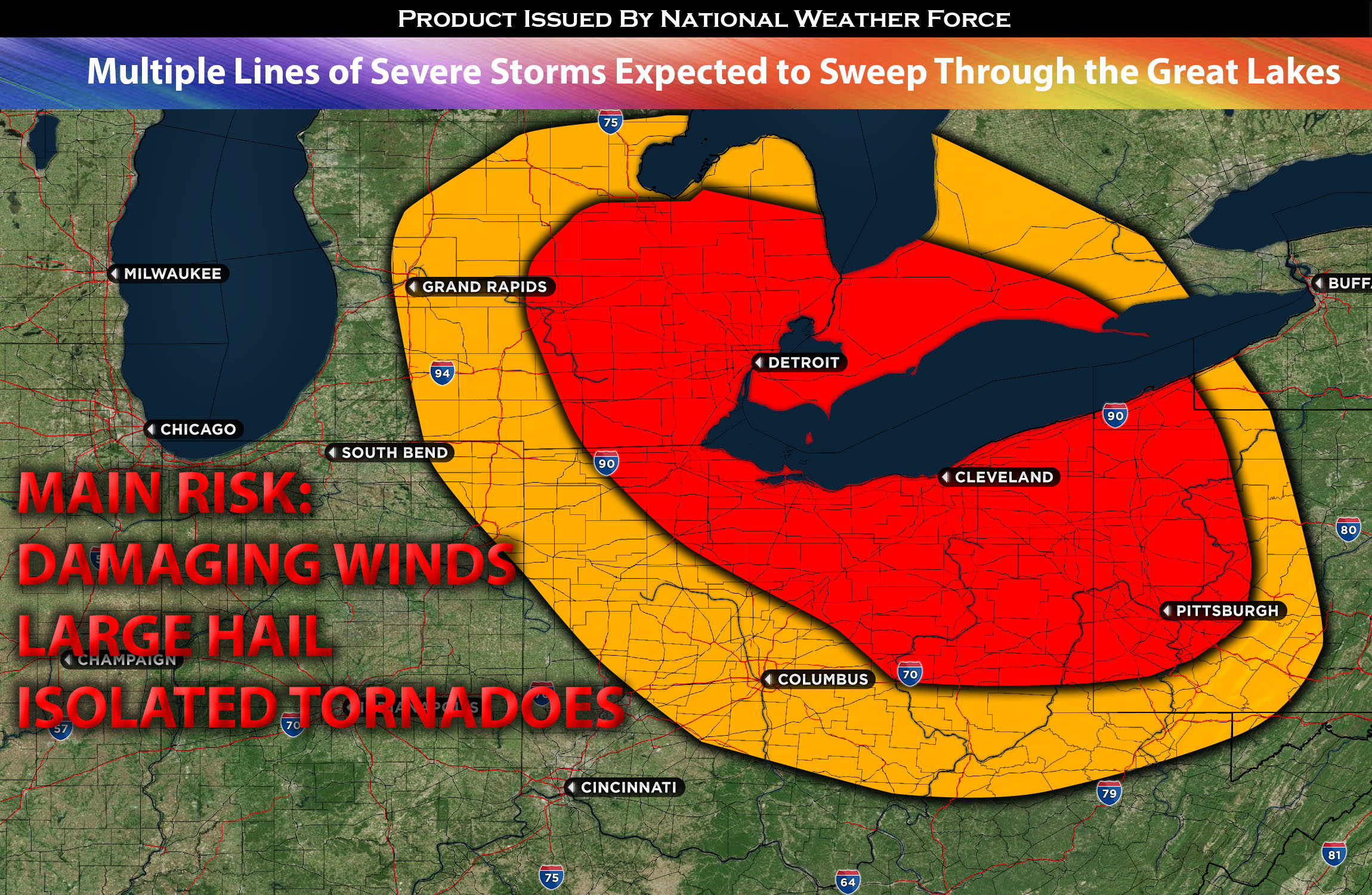
For MI Area Early Morning:
With a decent, moderately low-level jet and warm advection (creating lift) to the east of a boundary, there will be moderate levels of instability over the MI area. Dew points in the 70s provide the necessary ingredients for thunderstorms to develop. These storms are expected to originate around northwest MI and move southeastward, forming a line as they intensify into severe storms. The primary threats from these storms are damaging winds and large hail, especially with discrete cells. However, as these storms move from MI into Ohio, they are anticipated to dissipate due to the more stable morning atmosphere and capping.
For Ohio and PA:
Another round of strong to severe storms, potentially an MCS (Mesoscale Convective System) also known as a squall line, which is a line of structured storms is expected to sweep southeastward from southeastern MI across eastern and southeastern OH. This is due to a strengthening of the low-level jet around Wednesday night into Thursday morning, combined with elevated instability (especially downward), already plenty of low-level moisture (from warm air advection), and strong buoyancy allowing for updraft strengths conducive to the formation of severe storms. The capping should also weaken for these parts of the region allowing for these storms to form. Capping is always a key portion of uncertainty with storms being able to form as too much of a capped airmass will diminish the risk for the formation of any organized storms. Parts of this storm line might also progress through portions of western PA. Given the instability levels and other contributing factors, some of these storms could produce large hail in addition to damaging straight-line winds in the affected regions. This storm line will continue to move south to southeastward into a more stable airmass, becoming less organized as they pass through neighboring states. As a result, the risk will decrease through the morning, leaving mainly heavy rain and thunderstorms for states further south before diminishing.
Main risk: large hail, damaging straight-line winds and perhaps an isolated tornado in the small timeframe of discrete cells in MI and Ohio overnight.
Timing: First rounds of storms will be in the morning of Wednesday through MI and parts of Ohio with more an organized line of storms into nighttime hours/early morning through Ohio and PA.
Locations Impacted: MI area, Ohio mainly northeastward and portions of western PA. A few lingering storms into KY and WV.
Stay tuned for more updates.
Sina⚡⚡
With over a decade of experience in forecasting severe thunderstorms, this individual is a seasoned forecaster and developer. Their expertise in severe weather forecasting and computer science is entirely self-taught, complemented by a foundation in Atmospheric Science from UNCO. They have dedicated their efforts to developing innovative tools that enhance the accuracy of analyzing large hail and tornadoes. As a significant contributor to the National Weather Force, they have played a crucial role in providing accurate and timely information, as well as developing tools to keep those affected well-informed.
NOTE: The alerts and outlooks posted here are customary made to inform. At times, which is often, you will see an alert forecast posted on here that you do not see elsewhere. That is fine, the track record of the main office is very high so maintain to follow an event when posted. These are custom concentrated alerts and outlooks that are created by National Weather Force team of experts.