
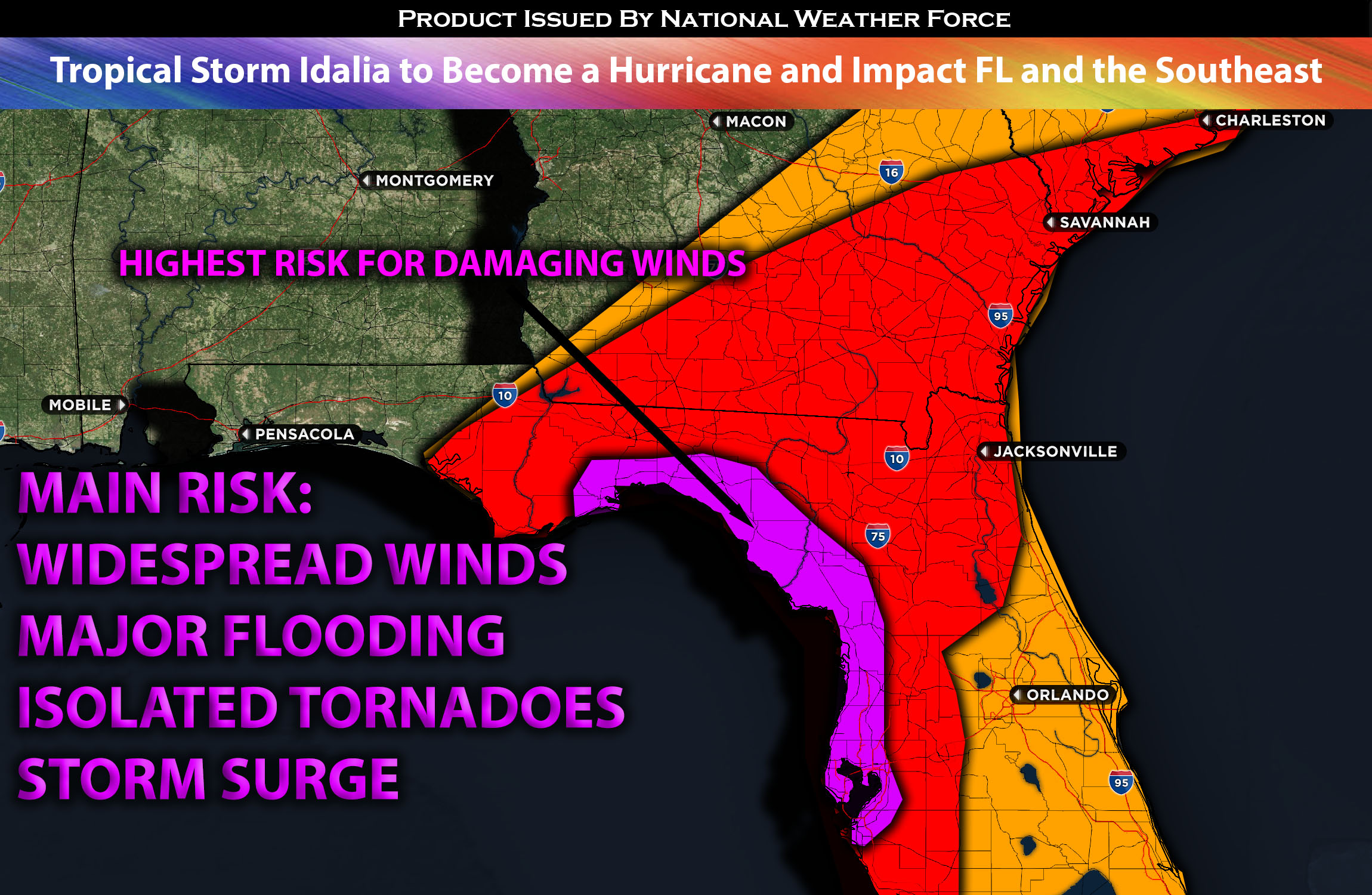
As Tropical Storm Idalia continues its northeastward movement, it will enter an environment with ideal conditions for rapid intensification. Idalia is also expected to start developing its eye core within the next few hours. The combination of favorable elements in this part of the waters, quick destabilization, and minimal shear to cause disorganization will enable Idalia to strengthen quickly, becoming a hurricane in the next 24 hours and potentially exceeding a Category 3 hurricane with rapid intensification before making landfall late Tuesday night or early Wednesday morning. Idalia is expected to bring core winds exceeding 115+ mph upon landfall around the Florida West or Panhandle (with impacts felt across western FL. That being said, her impacts will be felt across Florida, with damaging winds, heavy rain, and storm surge impacting the coastal areas. Some areas of northwestern FL will expect up to 11ft life threatening surges. As Idalia continues its track through northwestern FL, it will bring impacts to Georgia and the Carolinas into Thursday. The strongest winds will be northeast of the eye core with heavy rainfall and flooding being the main risk for all impacted regions. Another risk to watch out for especially to the northeast of the core of Idalia is isolated tornadoes given the high vertical shear values and with any clearing causing elevated instability bringing embedded super cells capable of isolated tornadoes towards Northwestern FL. Remnant moisture will also continue to impact the southeast way ahead of Idalia bringing heavy rainfall across this region.
Main risk: Widespread damaging winds, heavy rainfall leading to flooding, storm surge, and isolated tornadoes especially near the core and east side of Idalia.
Timing: Tropical storm Idalia is expected to go through rapid intensification before making landfall as a hurricane sometime on Tuesday night/Wednesday early morning. As she makes landfall, she will fall apart very quickly with tropical storm winds being felt through Wednesday and very heavy rainfall cross southern portions of GA and SC into Thursday before pushing out back into the waters by Thursday night.
Locations Impacted: FL Panhandle, FL West, FL northwest, north, northeast; GA south, southeast; SC east; NC east especially the coasts.
Stay tuned for more updates.
Sina⚡⚡
With over a decade of experience in forecasting severe thunderstorms, this individual is a seasoned forecaster and developer. Their expertise in severe weather forecasting and computer science is entirely self-taught, complemented by a foundation in Atmospheric Science from UNCO. They have dedicated their efforts to developing innovative tools that enhance the accuracy of analyzing large hail and tornadoes. As a significant contributor to the National Weather Force, they have played a crucial role in providing accurate and timely information, as well as developing tools to keep those affected well-informed.
NOTE: The alerts and outlooks posted here are customary made to inform. At times, which is often, you will see an alert forecast posted on here that you do not see elsewhere. That is fine, the track record of the main office is very high so maintain to follow an event when posted. These are custom concentrated alerts and outlooks that are created by National Weather Force team of experts.