
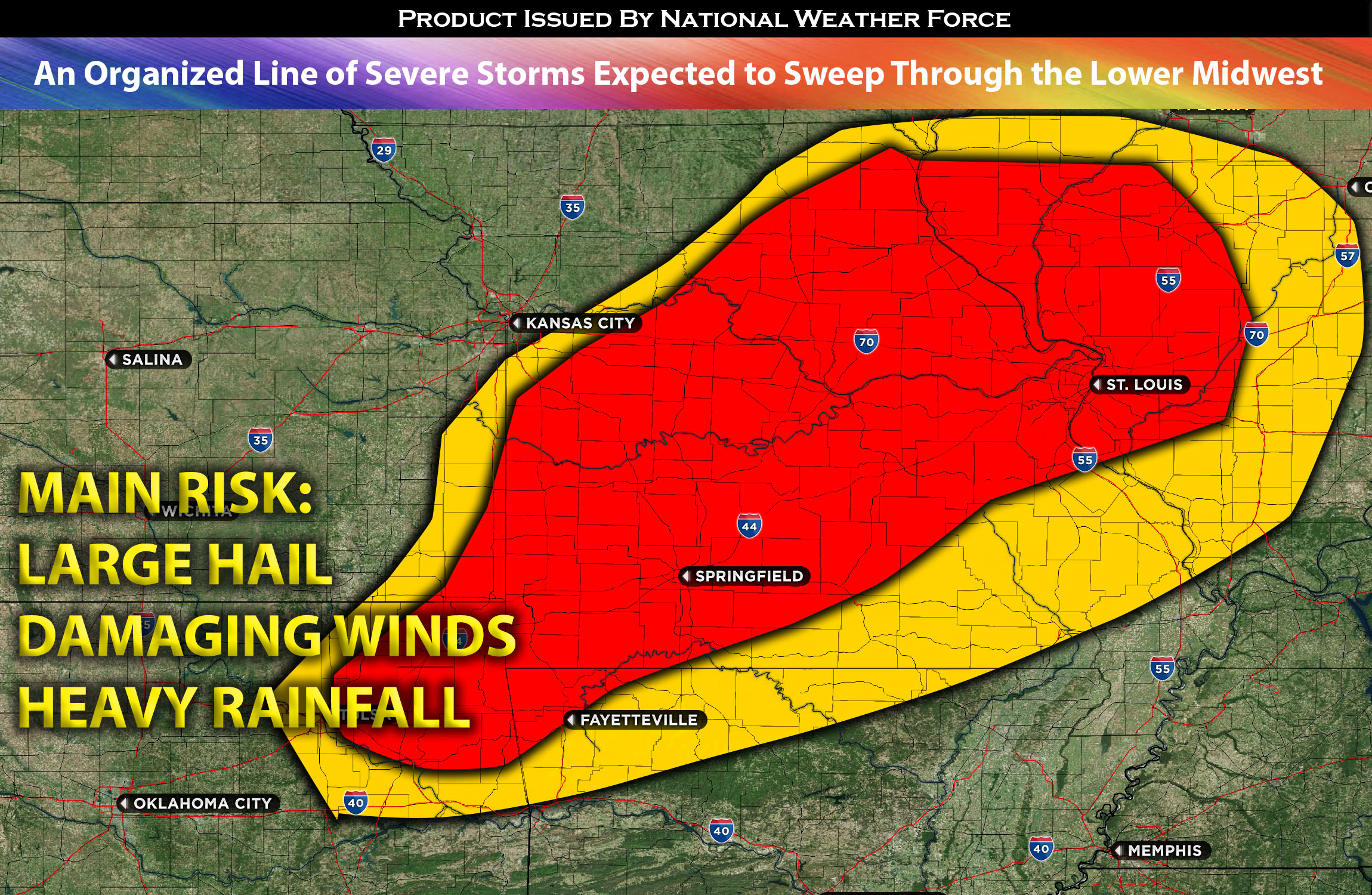
For MO through OK:
At higher atmospheric levels, a pronounced shortwave trough runs from CO to the Dakotas within a humid setting, promoting atmospheric lift. Meanwhile, a lingering cold front at the surface will settle across the Midwest, stretching from MN, through MO, and reaching Oklahoma. Ahead of it, the air will be moist with dew points predominantly in the 60s, though some spots might touch the low 70s. Enhanced by daylight heating, the MLCAPE (a measure of instability) will rise to about 2500 J/kg. This is particularly expected in parts of MO and northeastern OK, as well as up north in the MN/WI region. Paired with an effective shear of 40-50 kts, this sets the stage for severe storm formation from MN, across MO, AR northwest and into northern OK. These storms will bunch together as they move east, thanks to the prevailing winds. There’s also potential for isolated cells to emerge, posing risks of sizable hail and forceful downdrafts. The storm’s most potent section seems to be over parts of MO, where a significant MCS (Mesoscale Convective System) might arise bringing damaging winds and heavy rainfall to the impacted regions.
IL through KY (overnight/Wed Morning):
While these storms are expected to lessen overnight, the ongoing instability might drive them into southern IL and parts of KY by Wednesday morning, with damaging winds and substantial rain being their main threats.
Main risk: large hail, damaging straight-line winds mainly. Very low risk for a tornado given the limited low-level shear.
Timing: Storms are expected to form as a cluster becoming a line around 4-5pm CDT with some discreet ones from MO down through OK and continue to strengthen with time throughout the evening from west to east especially across MO as they organize into an MCS. These storms will then strengthen and continue throughout the overnight hours and into Wednesday morning into IL southward.
Locations Impacted: MO westward, central, northern into eastern areas; OK northward into portions of eastern areas before dissipating; Northwest AR possible as the line moves east; then as the storms move eastward across MO into southern IL and portions of KY/IN potentially.
Stay tuned for more updates.
Sina⚡⚡
With over a decade of experience in forecasting severe thunderstorms, this individual is a seasoned forecaster and developer. Their expertise in severe weather forecasting and computer science is entirely self-taught, complemented by a foundation in Atmospheric Science from UNCO. They have dedicated their efforts to developing innovative tools that enhance the accuracy of analyzing large hail and tornadoes. As a significant contributor to the National Weather Force, they have played a crucial role in providing accurate and timely information, as well as developing tools to keep those affected well-informed.
NOTE: The alerts and outlooks posted here are customary made to inform. At times, which is often, you will see an alert forecast posted on here that you do not see elsewhere. That is fine, the track record of the main office is very high so maintain to follow an event when posted. These are custom concentrated alerts and outlooks that are created by National Weather Force team of experts.