
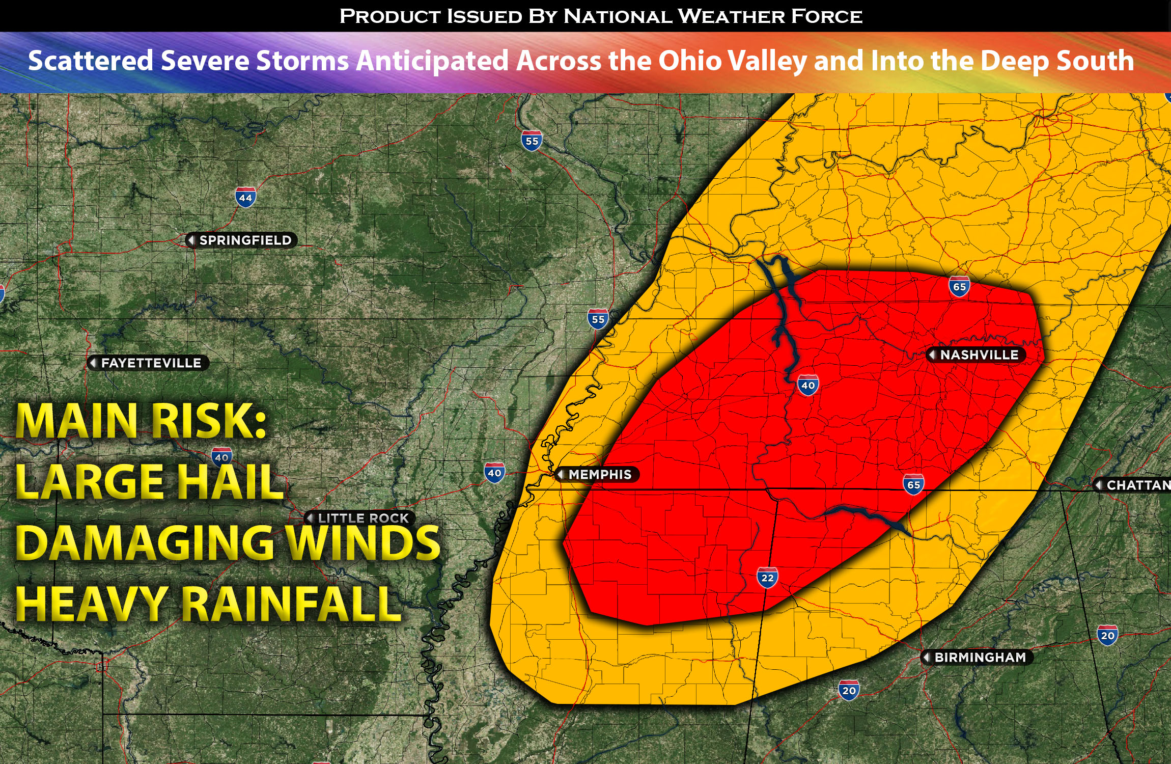
 For KY through TN and MS:
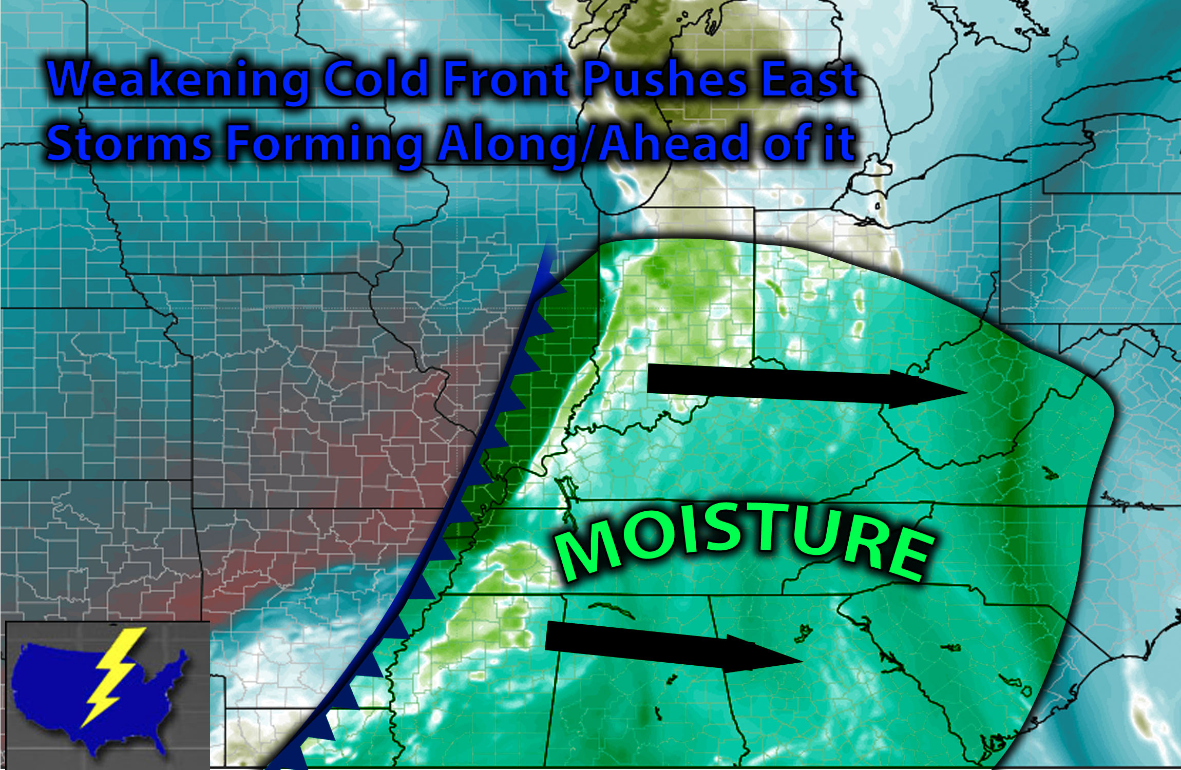
In the upper levels, a shortwave trough will make its way from the west to the east, accompanied by multiple disturbances that will create more lift in the upper levels. At the surface, a weakening cold front will continue to advance eastward, bringing with it warm air advection. As daylight heating destabilizes the air ahead of this front, it will allow for the formation of scattered thunderstorms along this warm, moist area. The most concentrated area of instability will be somewhat elevated in TN and portions of the KY area, extending southward into parts of MS. Consequently, storms are expected to form along the cold front in the Ohio Valley, with a higher concentration in those areas during the afternoon/evening hours. The primary risks with these storms are isolated large hail and potentially some damaging winds, especially if there is sufficient effective shear. The most intense effective shear, if present, will be in TN and extending south into parts of MS, where storms might be slightly more organized. However, the overall risk will be somewhat limited due to the lack of effective shear in the Ohio Valley, which is primarily in the range of 15-25 kts, and locally 25-30 kts. Still, there will be enough instability to allow storms to form and potentially become severe. Low-level moisture will also be notable, with dew points in the low 70s across this area.
Visualization of Storms and Mesoanalysis:
Main risk: Isolated large hail, damaging straight-line winds mainly. Very low risk for a tornado given the limited low-level shear.
Timing: Storms are expected to form ahead and along the weakening front scattered in nature from KY down through TN and into portions of MS around 3-4pm and move eastward across the impacted areas. Given the weakening cold front less advection in a more stable airmass will cause these storms to dissipate during the night as daylight heating dissipate so storms will be a lot less long lived except for some local spots across TN, MS area.
Locations Impacted: Portions of KY westward especially, into portions of central TN and south into MS northern area before dissipating into AL.
Stay tuned for more updates.
Sina⚡⚡
With over a decade of experience in forecasting severe thunderstorms, this individual is a seasoned forecaster and developer. Their expertise in severe weather forecasting and computer science is entirely self-taught, complemented by a foundation in Atmospheric Science from UNCO. They have dedicated their efforts to developing innovative tools that enhance the accuracy of analyzing large hail and tornadoes. As a significant contributor to the National Weather Force, they have played a crucial role in providing accurate and timely information, as well as developing tools to keep those affected well-informed.
NOTE: The alerts and outlooks posted here are customary made to inform. At times, which is often, you will see an alert forecast posted on here that you do not see elsewhere. That is fine, the track record of the main office is very high so maintain to follow an event when posted. These are custom concentrated alerts and outlooks that are created by National Weather Force team of experts.