
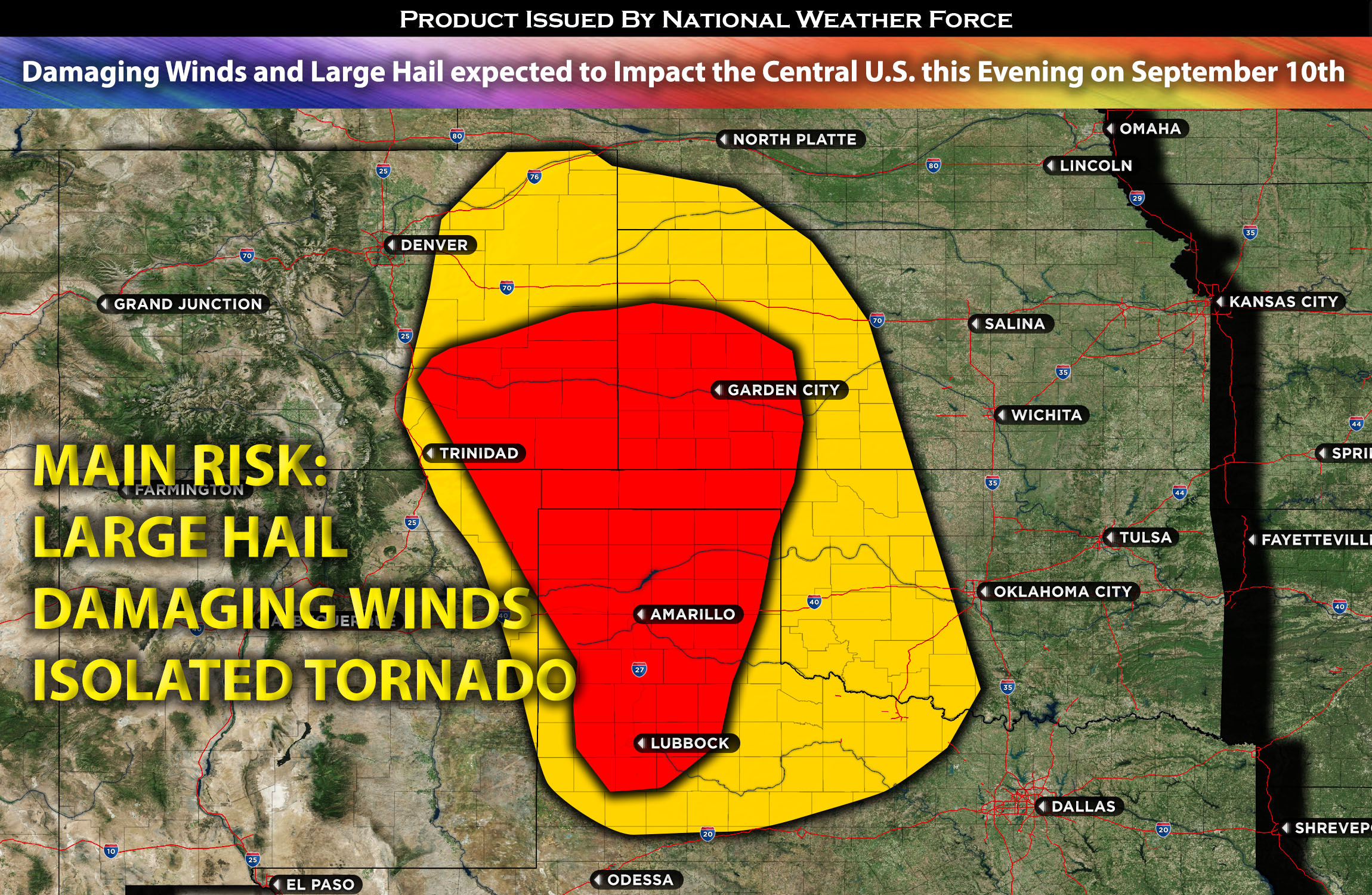
Outlook for eastern CO, western KS, TX panhandle, and OK panhandle: Widespread thunderstorms are expected across the area, with a few storms becoming severe and capable of producing large hail and damaging winds. A few storms may also have a risk for a few isolated tornadoes. These storms are anticipated to form this evening, moving through the affected regions (check timing and impact details below).
Timing & Impact Details: Storms are expected to form in the eastern areas of CO, with even stronger storms anticipated to develop in the TX panhandle and extend north into the southwestern area of KS, given the concentrated ingredients present around 4-5pm CDT. These storms are forecasted to move eastward, covering areas of southwest KS and the southeast TX panhandle. As they advance, it’s anticipated that these storms will merge, forming a linear cluster that will move across western KS, down through the TX/OK panhandle, and further south towards Lubbock, TX by this evening.
The primary threats posed by these clustered storms include damaging straight-line winds and large hail. As these storms transition away from the unstable environment, their intensity is likely to diminish, primarily presenting as rain and lightning threats as they move eastward across central and northern TX. This stormy activity is projected to continue overnight and into Monday morning. However, these storms are expected to weaken rapidly as they near Dallas, TX, due to the more stable airmass in that region.
Forecast Details:
In the upper levels of the atmosphere, a weakening high-pressure system continues to drive a westerly flow into areas of KS bordering CO and the TX panhandle. At the surface, a weak low-pressure system and a stationary front are present over the area. This combination promotes additional lift, and when combined with a destabilizing atmosphere, allows the cap to weaken and break in certain areas. With effective shear exceeding 30 kts, there’s potential for storms to form and intensify into severe weather, with the primary risks being damaging winds and large hail.
There’s also a slight elevation in low-level shear, attributed to the positioning of the low-pressure system, providing a brief window for the potential development of an isolated tornado or two.
Main risk: large hail, damaging straight-line winds mainly. Isolated tornado possible due to elevated vertical shear.
Stay tuned for more updates.
Sina⚡⚡
With over a decade of experience in forecasting severe thunderstorms, this individual is a seasoned forecaster and developer. Their expertise in severe weather forecasting and computer science is entirely self-taught, complemented by a foundation in Atmospheric Science from UNCO. They have dedicated their efforts to developing innovative tools that enhance the accuracy of analyzing large hail and tornadoes. As a significant contributor to the National Weather Force, they have played a crucial role in providing accurate and timely information, as well as developing tools to keep those affected well-informed.
NOTE: The alerts and outlooks posted here are customary made to inform. At times, which is often, you will see an alert forecast posted on here that you do not see elsewhere. That is fine, the track record of the main office is very high so maintain to follow an event when posted. These are custom concentrated alerts and outlooks that are created by National Weather Force team of experts.