
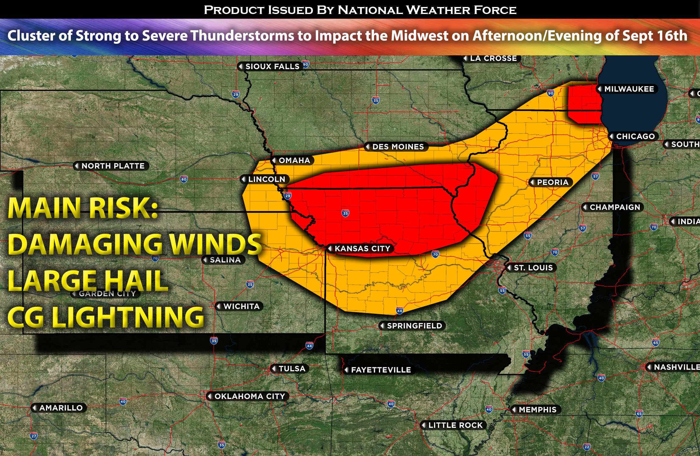
In northwestern IL bordering WI and northwestern/northern MO:
A cluster of storms that are capable of being severe is expected to impact the region given the somewhat unstable airmass. These storms will be in a hit or miss fashion (some get hit while others only feel muggy conditions). The strongest storms may produce large hail, damaging winds and CG lightning.
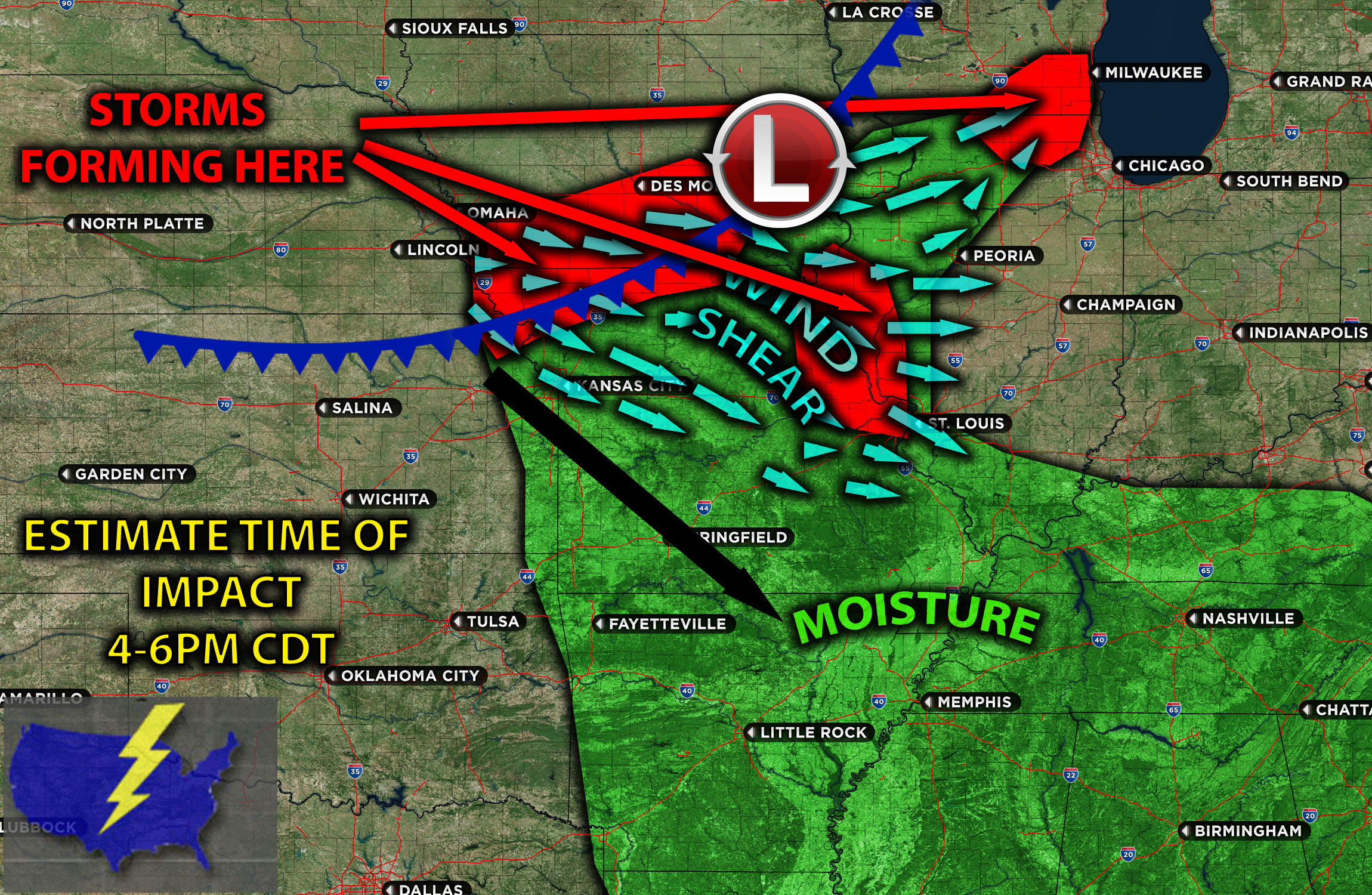
Timing & Impact Details: There are two areas of main concern. Storms are expected to form in northwestern IL bordering IA tomorrow afternoon/evening depending on when destabilization occurs (around 4-5pm CDT). These storms will be moving southeastward across the impact regions. Another area of concern will be just northwest of IL and potentially a few reaching it to Chicago as well given the unstable airmass around 4-6pm CDT.
Forecast Details:
In the upper atmosphere, an upper-level trough is set to shift southeast across the Upper Midwest and central Plains on Saturday. Concurrently, a corresponding cold front will progress southeastward over the mid-Missouri and upper Mississippi regions. Ahead of this front, surface dewpoints ranging from the upper 50s to the lower 60s F are expected to create a zone of moderate instability by the afternoon. This will stretch from southeast Nebraska to southern Iowa and northern Missouri. As the day’s temperatures rise, thunderstorms will form near the front, moving southeastward through a somewhat humid air mass. The presence of somewhat elevated effective shear, between 20-25 kts (sporadically), will allow some of these clusters of storms to intensify, potentially becoming strong and severe. These storms could produce large hail and damaging winds. The primary focus for these clusters will be in two areas: one in northwestern MO and the other just northwest of Chicago. A few storms may also affect the Chicago area, especially given the air mass expected in the evening on Saturday.
Visualization of Mesoanalysis and Details:
Main risk: Large hail, damaging winds, tornado risk too low due to lack of low-level shear.
Stay tuned for more updates.
Sina⚡⚡
With over a decade of experience in forecasting severe thunderstorms, this individual is a seasoned forecaster and developer. Their expertise in severe weather forecasting and computer science is entirely self-taught, complemented by a foundation in Atmospheric Science from UNCO. They have dedicated their efforts to developing innovative tools that enhance the accuracy of analyzing large hail and tornadoes. As a significant contributor to the National Weather Force, they have played a crucial role in providing accurate and timely information, as well as developing tools to keep those affected well-informed.
NOTE: The alerts and outlooks posted here are customary made to inform. At times, which is often, you will see an alert forecast posted on here that you do not see elsewhere. That is fine, the track record of the main office is very high so maintain to follow an event when posted. These are custom concentrated alerts and outlooks that are created by National Weather Force team of experts.