
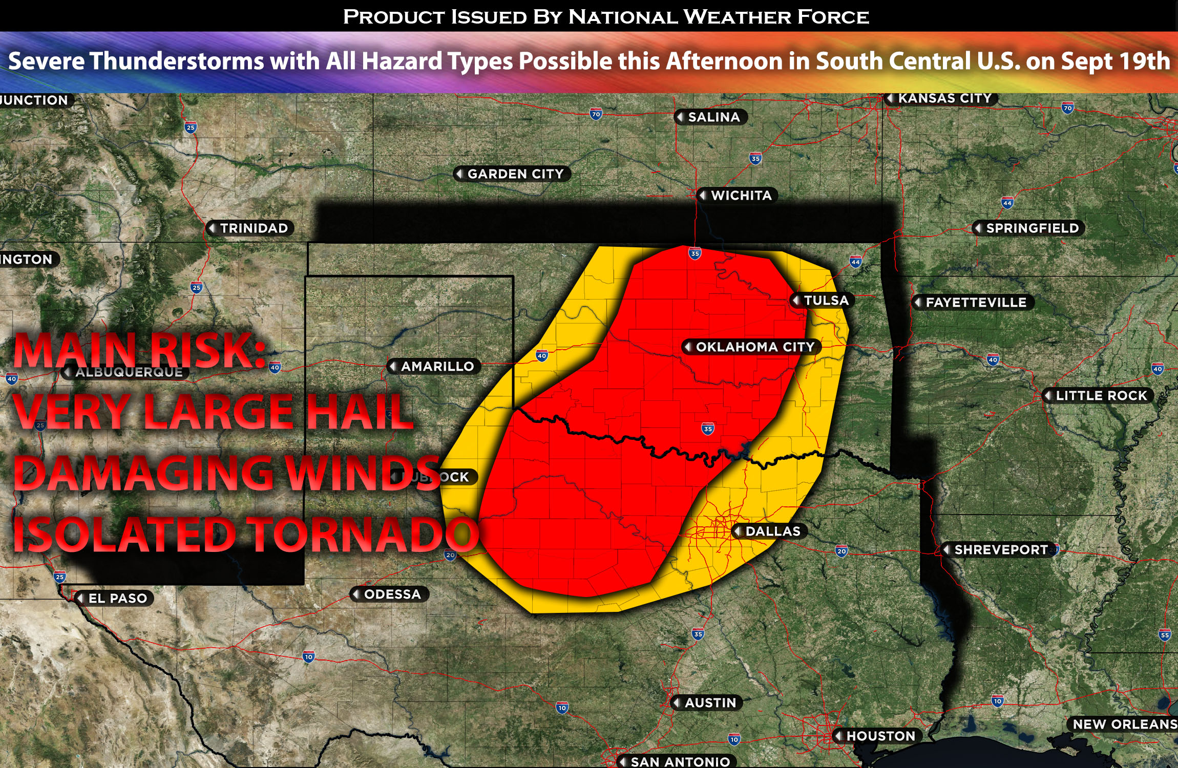
In northern and central Oklahoma down into northern TX including west of Dallas TX:
A cluster of storms with a few discrete cells that are capable of being severe is expected to impact the region given the unstable airmass. These storms will be in a hit or miss fashion (some get hit while others only feel muggy conditions). The strongest storms may produce large hail, damaging winds and perhaps a few isolated tornadoes. A few of these storms might impact western Dallas TX given the unstable airmass with the best formation chances being west of Dallas and bordering OK/TX area.
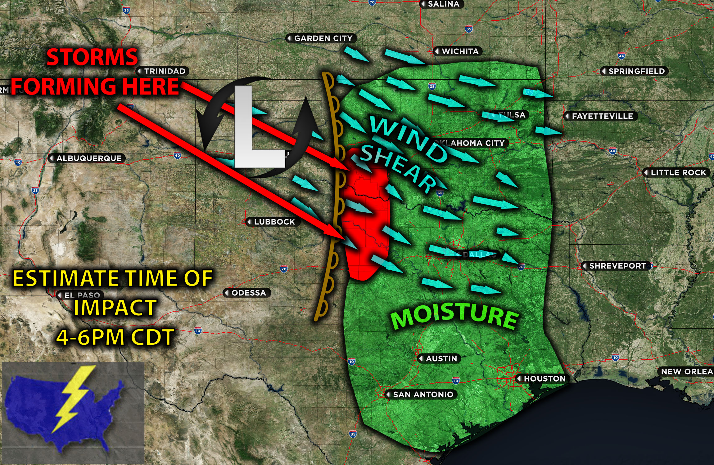
Timing & Impact Details: There are two areas of main concern. Storms are expected to form in northern TX bordering OK this afternoon/evening depending on when destabilization occurs (around 4-5pm CDT). These storms will be moving eastward across the impact regions. Another area of concern will be just northwest of TX into northern TX and potentially a few reaching western Dallas (mainly westward) as well given the unstable airmass around the same timeframe.
Forecast Details:
In the upper levels at 500mb, multiple strong shortwaves are expected to move through central/southern OK and portions of northern TX. At the surface, a dryline coupled with a cold front is anticipated to be positioned right over western OK, extending down into northern TX. Along this feature, low-level moisture in the mid-60s is expected, with a warm front to its north. There’s also an anticipation of a low-pressure system forming, if it hasn’t already, over the TX panhandle. This will allow for increased vertical shear over OK. Combined with moderate instability over OK and TX, and extending into parts of Dallas, the conditions are conducive for the development of storms with all hazard types. Westerly flow (winds coming from the west) will allow for discrete cells before clustering together into a squall line with the strengthening low-level flow. A minor cap is currently present over the area, but given its weak nature, a few thunderstorms are expected. This might decrease the risk slightly, depending on atmospheric mixing. The limited moisture spread in Dallas, TX, might also reduce the tornado risk, while high instability will be enhancing the likelihood of large hail and damaging winds this evening. These storms will form sometime this afternoon as destabilization allowing storms to form from the west and move east through the impacted regions.
Visualization of Mesoanalysis and Details:
Main risk: Large hail, damaging winds, isolated tornadoes possible due to somewhat elevated vertical shear.
Stay tuned for more updates.
Sina⚡⚡
With over a decade of experience in forecasting severe thunderstorms, this individual is a seasoned forecaster and developer. Their expertise in severe weather forecasting and computer science is entirely self-taught, complemented by a foundation in Atmospheric Science from UNCO. They have dedicated their efforts to developing innovative tools that enhance the accuracy of analyzing large hail and tornadoes. As a significant contributor to the National Weather Force, they have played a crucial role in providing accurate and timely information, as well as developing tools to keep those affected well-informed.
NOTE: The alerts and outlooks posted here are customary made to inform. At times, which is often, you will see an alert forecast posted on here that you do not see elsewhere. That is fine, the track record of the main office is very high so maintain to follow an event when posted. These are custom concentrated alerts and outlooks that are created by National Weather Force team of experts.