
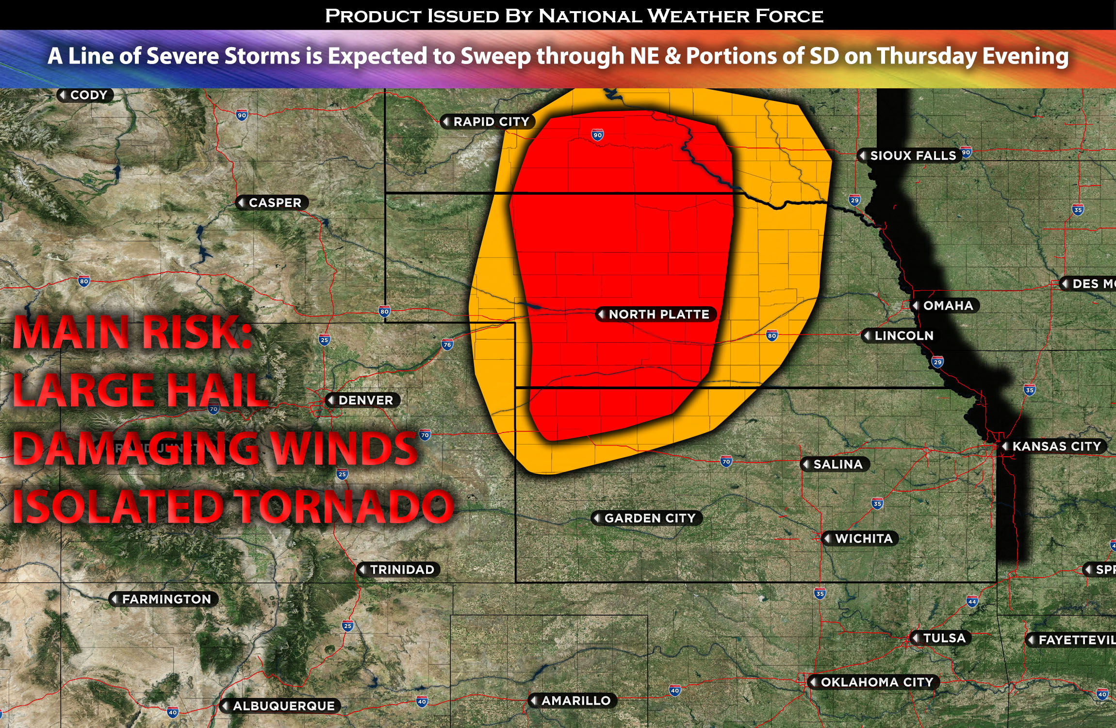
 Western & Central Nebraska into portions of Southern SD:
Clusters of severe thunderstorms, which are likely to evolve into an MCS (Mesoscale Convective System) or become an organized line of storms, are expected to impact portions of western and central NE possible stretching up to southern SD. These storms are forecasted to produce large hail and damaging winds, with the threat of damaging winds amplifying overnight. The greatest likelihood of these events is centered around western and central NE, a result of the lift from the surface low pressure and the influence of the shortwave troughs.
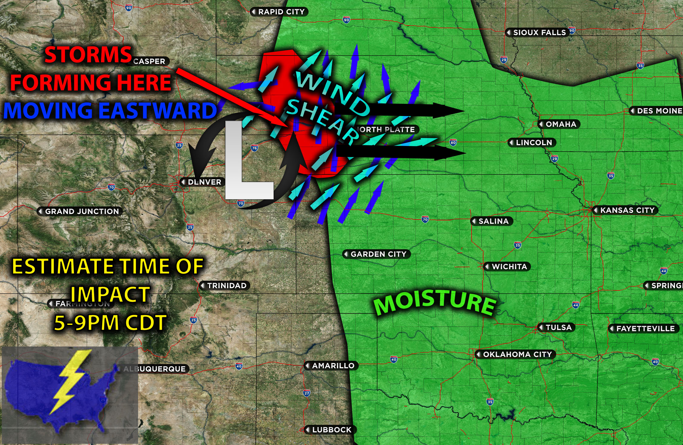
Timing & Impact Details: As the atmosphere continues to destabilize in the afternoon, storms are anticipated to form around 5-6pm CDT in western NE. These will likely evolve into an MCS and move eastward across the region late in the evening and overnight, affecting areas including North Platte. These storms are forecasted to produce large hail and damaging winds, with the threat of damaging winds amplifying overnight before diminishing to the east in a more stable Atmosphere.
Forecast Details:
In the upper levels of the atmosphere, two troughs are set to merge, forming a cut-off low. As this system develops, it is projected to move eastward, positioning itself around the Rocky Mountains by Thursday, or potentially becoming more concentrated by Friday. However, sufficient flow from the jet stream will ensure the necessary ingredients are in place. A key factor to monitor is the extent to which the high pressure to its south might inhibit it from becoming too concentrated or adopting a negative tilt. Such a pattern is commonly observed during springtime outbreaks.
At the surface, a low is anticipated near the CO-KS border. Ahead of this system, there will be moisture advection, with dew points in the low levels expected to reach the upper 60s. When combined with daytime heating, elevated instability, mid-layer shear, and an upper-level jet delivering 40-50 kts of west to southwesterly flow, the stage is set for storms capable of producing large hail, damaging straight-line winds, and even tornadoes if the low-level shear intensifies. Given the notable downward CAPE (signifying instability), it’s likely these storms will evolve into an MCS.
Visualization of Mesoanalysis and Details:
Main risk: Large hail, damaging winds, isolated tornadoes possible due to somewhat elevated vertical shear from the forming surface low.
Stay tuned for more updates.
Sina⚡⚡
With over a decade of experience in forecasting severe thunderstorms, this individual is a seasoned forecaster and developer. Their expertise in severe weather forecasting and computer science is entirely self-taught, complemented by a foundation in Atmospheric Science from UNCO. They have dedicated their efforts to developing innovative tools that enhance the accuracy of analyzing large hail and tornadoes. As a significant contributor to the National Weather Force, they have played a crucial role in providing accurate and timely information, as well as developing tools to keep those affected well-informed.
NOTE: The alerts and outlooks posted here are customary made to inform. At times, which is often, you will see an alert forecast posted on here that you do not see elsewhere. That is fine, the track record of the main office is very high so maintain to follow an event when posted. These are custom concentrated alerts and outlooks that are created by National Weather Force team of experts.