
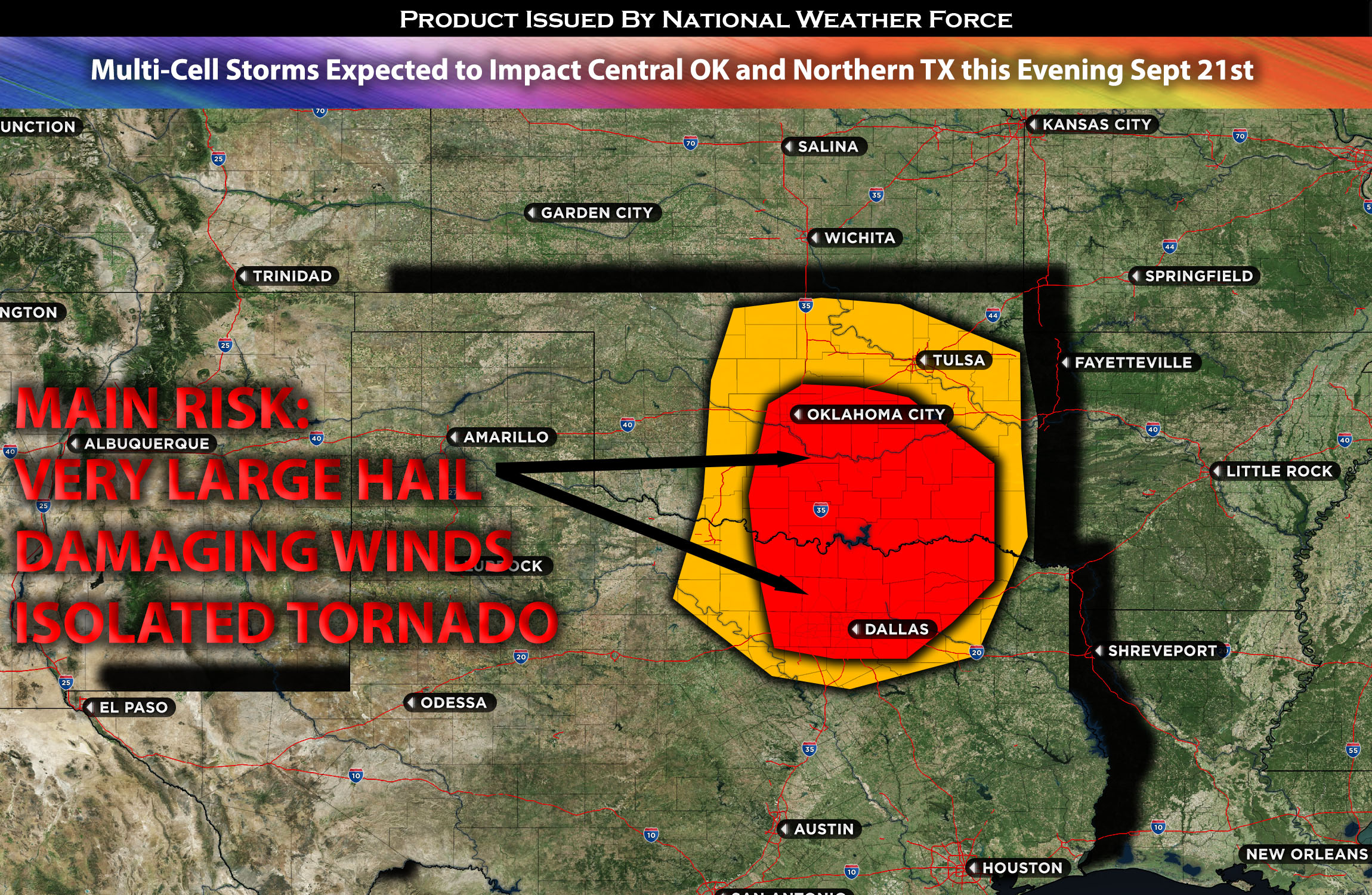
 Central/Southern Oklahoma into Northern TX:
Scattered thunderstorms are expected to form, capable of producing large hail, damaging winds, and perhaps a few isolated tornadoes due to the dynamics of veering winds with height. As these storms progress, they will bow out, becoming a damaging wind threat for the areas to the east of their path.
Timing & Impact Details: Storms are anticipated to form around 3-4pm CDT over central/southern OK and extend into the northern TX area. The majority of these storms are expected to initiate west of the I-35 in OK, extending to the western parts of Dallas, TX, and will likely move southeastward, affecting areas of Dallas, TX, and southern Oklahoma. As they progress, they will likely lose strength in southeastern OK and northeastern TX. Initially, these storms are forecasted to pose a significant large hail threat. As they evolve, they may bow out into clusters, sweeping through northern TX and central/southern Oklahoma during the evening and overnight hours. A few of these storms could manifest as supercells, posing risks for all hazard types, particularly in a brief window around 5-6pm CDT. As the night progresses, the predominant threat will shift to damaging straight-line winds.
Forecast Details:
In the upper levels of the atmosphere, multiple shortwaves are expected over the plains, with one positioned over OK and Northern TX by late this afternoon. This will coincide with strong southwesterly flow resulting from a developing cut-off low, which is gradually taking shape as two troughs merge. Ample deep layer shear, in conjunction with high levels of instability (especially downward) and moisture advection, will foster the formation of storms from central Oklahoma down to northern TX. These storms are capable of producing very large hail, damaging winds, and perhaps a few isolated tornadoes, given the existing flow and slightly enhanced vertical shear. As the evening progresses, some of these storms are likely to transition into bow echoes, posing a significant straight-line wind threat for eastern parts of Oklahoma.
Main risk: Large hail, damaging winds, isolated tornadoes possible due to somewhat elevated vertical shear from the forming surface low.
Stay tuned for more updates.
Sina⚡⚡
With over a decade of experience in forecasting severe thunderstorms, this individual is a seasoned forecaster and developer. Their expertise in severe weather forecasting and computer science is entirely self-taught, complemented by a foundation in Atmospheric Science from UNCO. They have dedicated their efforts to developing innovative tools that enhance the accuracy of analyzing large hail and tornadoes. As a significant contributor to the National Weather Force, they have played a crucial role in providing accurate and timely information, as well as developing tools to keep those affected well-informed.
NOTE: The alerts and outlooks posted here are customary made to inform. At times, which is often, you will see an alert forecast posted on here that you do not see elsewhere. That is fine, the track record of the main office is very high so maintain to follow an event when posted. These are custom concentrated alerts and outlooks that are created by National Weather Force team of experts.