
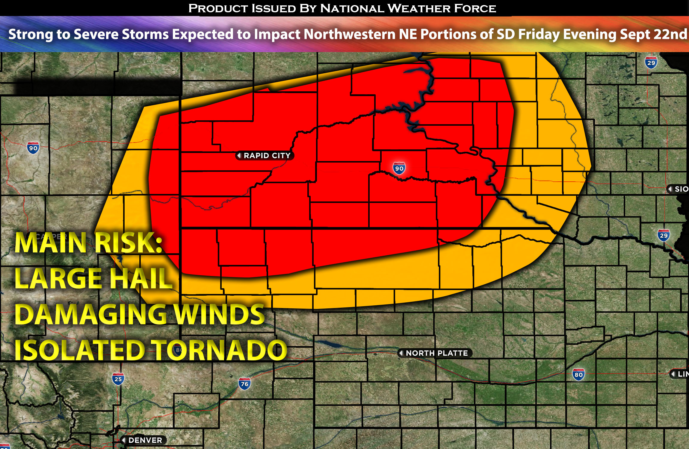
Northwestern NE through Southwestern SD extending to southern SD and northern NE:
Scattered thunderstorms are most likely to form, capable of producing large hail, damaging winds, as these storms progress, they will bow out, becoming a damaging wind threat for the areas to the northeast of their path across SD central area before dissipating.
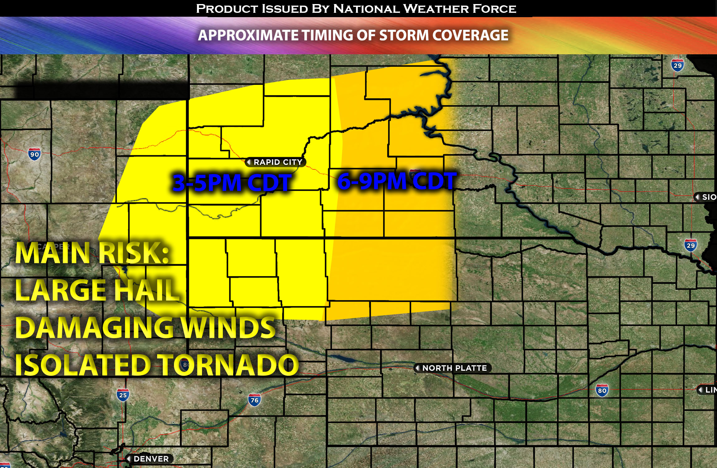
Timing & Impact Details: Storms are anticipated to form around 3-4pm CDT over WY and western SD with a few scattered storms possible in western NE. As they progress, they will likely lose strength across SD. Initially, these storms are forecasted to pose a large hail threat. As they evolve, they may bow out into clusters, sweeping through northern SD and NE and during the evening and overnight hours. As the night progresses, the predominant threat will shift to damaging straight-line winds before diminishing overnight as they move into more a stable atmosphere over central SD.
Approximate Timing of Storm Coverage:
Forecast Details:
In the upper atmosphere, an upper-level Cyclone is expected to be located near the junction of OR, ID, and NV. Throughout the day, it will move eastward, with a strong mid-level flow circulating around it into the central Plains. At the surface, due to atmospheric trough, a surface low will be positioned in the central Plains with another one in MT. Furthermore, a warm front is anticipated, leading to an ascent across the central and southern Plains. This scenario, combined with low and mid-level moisture, a potent low-level jet over the warm front, and the large-scale ascent from the approaching cut-off low, will create conditions conducive for strong to severe storms across NE and SD. The primary risks, given the deep-layer shear and downward instability, will be large hail and damaging winds. However, there’s a limited tornado risk due to the constrained low-level shear.
Main risk: Large hail, damaging winds, isolated tornadoes possible due to limited vertical shear.
Stay tuned for more updates.
Sina⚡⚡
With over a decade of experience in forecasting severe thunderstorms, this individual is a seasoned forecaster and developer. Their expertise in severe weather forecasting and computer science is entirely self-taught, complemented by a foundation in Atmospheric Science from UNCO. They have dedicated their efforts to developing innovative tools that enhance the accuracy of analyzing large hail and tornadoes. As a significant contributor to the National Weather Force, they have played a crucial role in providing accurate and timely information, as well as developing tools to keep those affected well-informed.
NOTE: The alerts and outlooks posted here are customary made to inform. At times, which is often, you will see an alert forecast posted on here that you do not see elsewhere. That is fine, the track record of the main office is very high so maintain to follow an event when posted. These are custom concentrated alerts and outlooks that are created by National Weather Force team of experts.