
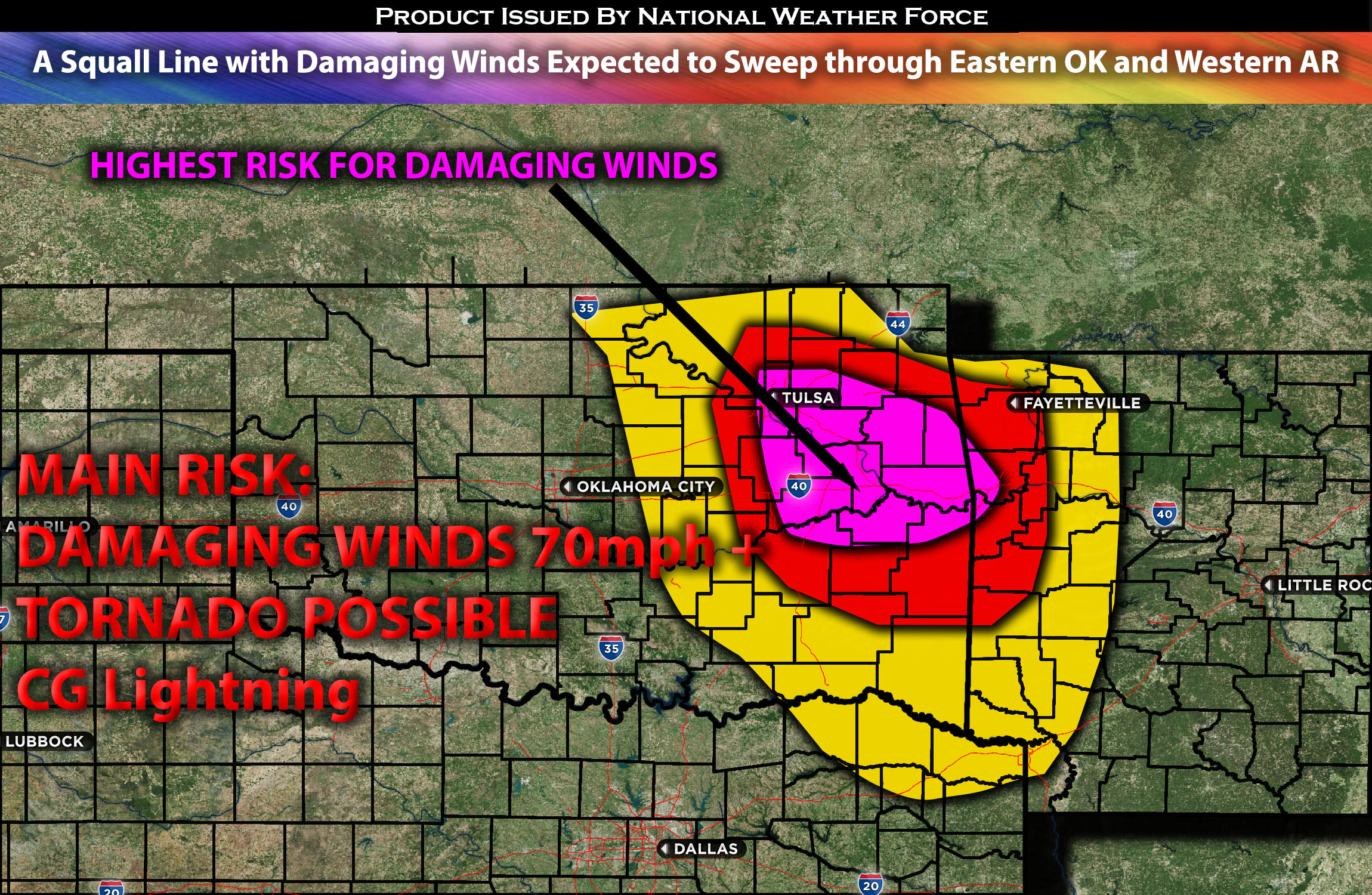
Northeastern OK stretching through Eastern OK and Western AR:
As the atmosphere destabilizes in the evening, severe storms capable of producing all types of hazards are expected to impact regions from southern MN through IA and into MO. These storms will be capable of generating large to very large hail, damaging winds, and possibly a few tornadoes, particularly considering the shear vectors with height.
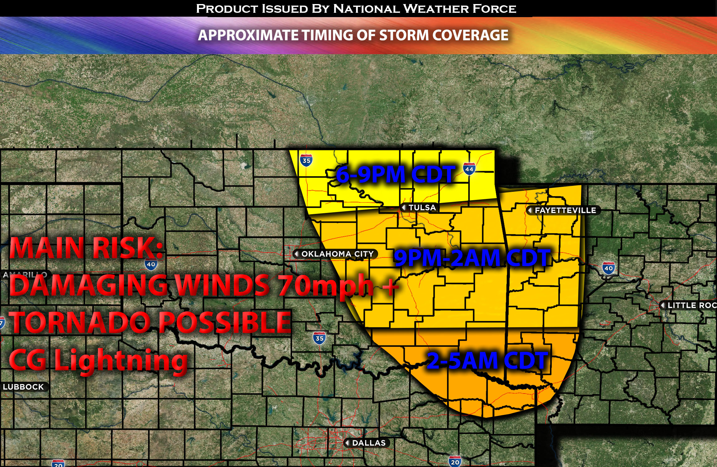
Timing & Impact Details: Determining the exact timing of storm formation might be challenging, as it hinges on when destabilization occurs. Storms are anticipated to develop around 5-6pm CDT. As the evening progresses, additional storm clusters—including a few discrete ones—are expected to form in OK and move southeastward across the affected areas. A line of severe storms is projected to pass through Tulsa, OK between 9-10pm CDT, with more clusters surfacing in the vicinity. The onset of these storms could potentially be earlier if destabilization accelerates. Given the combination of factors and downward instability, these storms are likely to become linear swiftly and proceed south southeastward across eastern OK, southwestern MO, and southwestern AR. They’ll continue in this direction along the AR-OK border and further into the night, ultimately reaching northeastern TX and southwestern AR by 4-5am CDT on Sunday morning. The primary threats include damaging straight-line winds exceeding 70mph and heavy rainfall in the affected areas.
Approximate Timing of Storm Coverage:
Forecast Details:
In the upper atmosphere, an upper-level low is progressing eastward and should reach the north-central plains, notably the NE/SD region, by afternoon, driven by a robust southwesterly flow. Concurrently at the surface, a low-pressure system is making its way across the KS/NE area, heralded by a boundary and warm front. There’s already a notable concentration of warm mid-level moisture, combined with elevated instability and vertical shear—with effective shear of 40-50kts evident from MN southwards to the IA/MO area. Consequently, scattered severe storms are already taking shape, with some cells detectable on radar. The amplification and focus of the low-level jet, alongside the existing low-level shear, raise concerns for various severe weather threats. This includes large hail, damaging winds, and potential tornadoes, accentuated by the shear vectors with altitude.
By evening, a burst of storm activity is forecasted over northeastern OK, tracking south southeastward. This storm cluster is poised to evolve into an MCS (Mesoscale Convective System), posing risks of damaging straight-line winds and potential tornadoes due to the pronounced vertical shear. Refer to timing and impact updates for more detailed information.
Main risk: damaging straight-line winds in excess of 70mph+, a few tornadoes possible due to the somewhat concentrated low-level shear (but mainly damaging winds).
Stay tuned for more updates.
Sina⚡⚡
With over a decade of experience in forecasting severe thunderstorms, this individual is a seasoned forecaster and developer. Their expertise in severe weather forecasting and computer science is entirely self-taught, complemented by a foundation in Atmospheric Science from UNCO. They have dedicated their efforts to developing innovative tools that enhance the accuracy of analyzing large hail and tornadoes. As a significant contributor to the National Weather Force, they have played a crucial role in providing accurate and timely information, as well as developing tools to keep those affected well-informed.
NOTE: The alerts and outlooks posted here are customary made to inform. At times, which is often, you will see an alert forecast posted on here that you do not see elsewhere. That is fine, the track record of the main office is very high so maintain to follow an event when posted. These are custom concentrated alerts and outlooks that are created by National Weather Force team of experts.