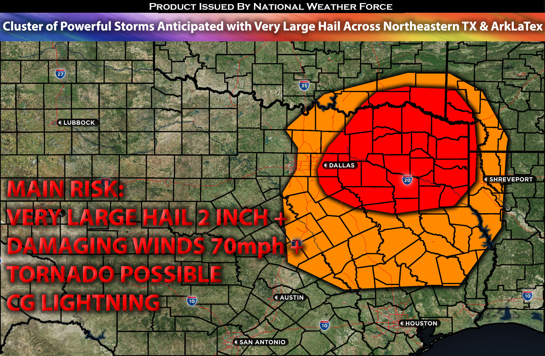
Northern to Northeastern TX and adjacent regions of Ark/La/Tex:
Severe thunderstorms expected capable of producing large hail, occasionally exceeding 2 inches (see forecast details for reasons), and damaging winds are anticipated primarily later this afternoon and for much of the evening continuing overnight southward. The areas most affected will be central to north/northeast Texas, with possible impacts in adjacent regions of southern Oklahoma and the ArkLaTex area.
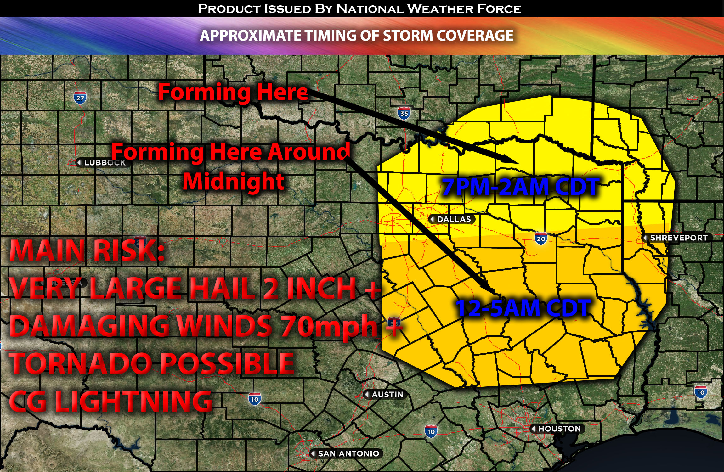
Timing & Impact Details: Determining the exact timing of storm formation might be challenging, as it hinges on when destabilization occurs. Storms are anticipated to explode around 6-8pm CDT just mainly south of Dallas TX and Northeast TX. As the evening progresses, additional storm clusters—including a few discrete ones—are expected to form and move south southeastward across the affected areas to the south (such as Red Oak,TX). The onset of these storms could potentially be earlier if destabilization accelerates. Given the combination of factors and instability, these storms are likely to produce very large hail and proceed south southeastward across eastern TX (southward). As the night progresses, the primary threats include damaging straight-line winds exceeding 70mph and heavy rainfall in the affected areas of ArkLaTex region.
Approximate Timing of Storm Coverage:

Forecast Details:
In the upper atmosphere, an eastward-moving shortwave trough is positioned over the southern Plains and is expected to approach the Northeast TX area by late this afternoon or evening. Simultaneously, a cold front is moving southward. Ahead of it, there is very deep moisture at low levels, with dew points predominantly in the 70s across the area. Destabilization due to heating is already in progress, with mostly clear skies allowing for a rapid increase in instability. This instability is expected to reach values of 2500-3500 J/kg, combined with an effective shear of 35-40kts at the 0-6km level. This combination is conducive for the development of powerful cells, most likely supercells, to erupt over the area. These could bring destructive hail, damaging winds, and perhaps a low risk of tornadoes in the evening. As nighttime sets in, these clusters of storms are likely to intensify across the region, with damaging winds and large hail persisting. The low-level jet is expected to remain focused on this warm advection ahead of the front, especially as the night progresses.
Main risk: Very Large Hail 2inch+, damaging winds 70+ mph, and tornado possible (low risk)
Stay tuned for more updates.
Sina⚡⚡
With over a decade of experience in forecasting severe thunderstorms, this individual is a seasoned forecaster and developer. Their expertise in severe weather forecasting and computer science is entirely self-taught, complemented by a foundation in Atmospheric Science from UNCO. They have dedicated their efforts to developing innovative tools that enhance the accuracy of analyzing large hail and tornadoes. As a significant contributor to the National Weather Force, they have played a crucial role in providing accurate and timely information, as well as developing tools to keep those affected well-informed.
NOTE: The alerts and outlooks posted here are customary made to inform. At times, which is often, you will see an alert forecast posted on here that you do not see elsewhere. That is fine, the track record of the main office is very high so maintain to follow an event when posted. These are custom concentrated alerts and outlooks that are created by National Weather Force team of experts.
