
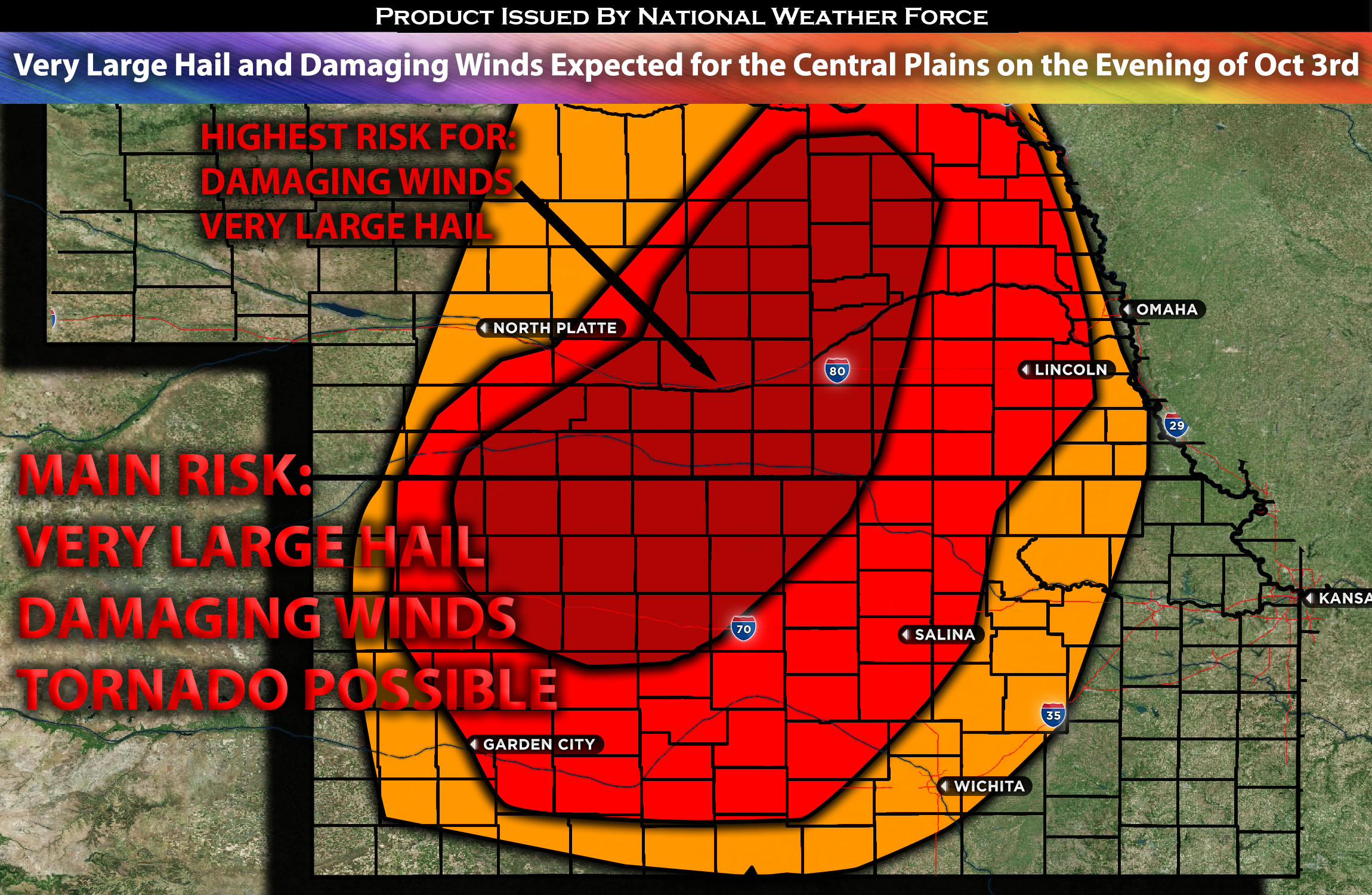
Central NE down through KS:
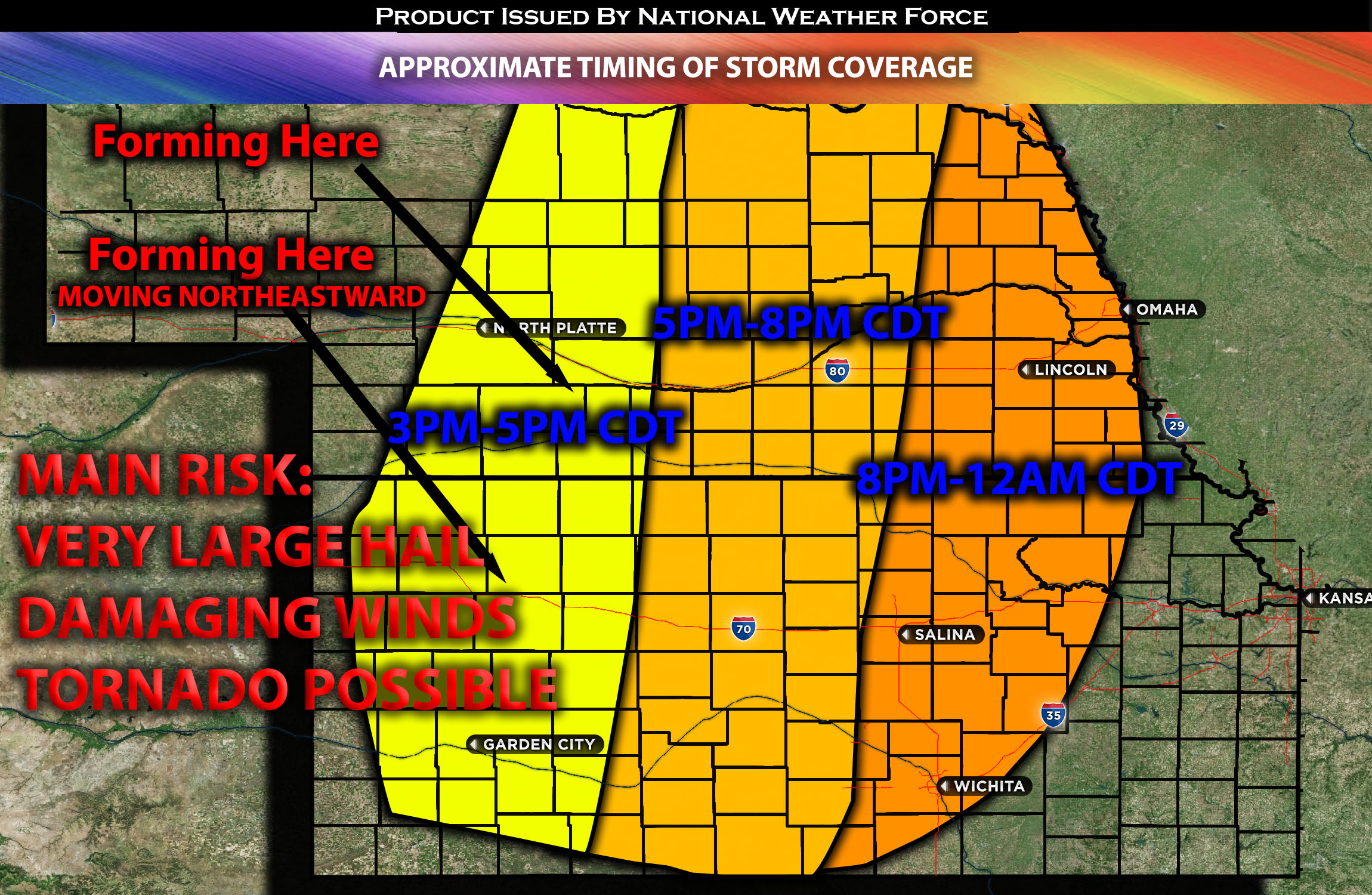
A few showers and scattered thunderstorms are expected to form around 2pm CDT, possibly earlier, but they will not be severe initially. However, as further destabilization occurs, a greater concentration of stronger to severe thunderstorms is anticipated to form across Northwestern KS and central NE. These storms can spontaneously produce severe weather, especially between 3-5pm CDT, with all types of hazards being a possibility. Over time, these storms will rapidly merge, forming a line that moves eastward to northeastward across central NE and down through central KS. This line will continue expanding in association with the advancing cold front throughout the night, reaching eastern NE and northeastern KS by 10pm. The strength of these storms will then gradually decrease, with more isolated damaging winds and predominantly heavy rain persisting through the night as the system moves northeastward (see graphics for details).
Approximate Timing of Storm Coverage:
Forecast Details:
In the upper levels of the atmosphere, an upper-level trough is moving eastward across the Plains. At the surface, a cold front is progressing eastward across the northern and central Plains. A surface low is expected to form over KS and will likely move northeastward over time. This will also position a dryline to its south, spanning the central and southern Plains. The upper-level trough will exert very strong forcing, introducing a 45-55 knot mid-level jet across KS and the south-central regions of KS during the afternoon and evening. The presence of low-level moisture, with dew points in the low 60s ahead of the dryline, combined with instability values ranging from 2000-2500 J/kg, will create conditions conducive for severe storms across the Plains. These storms will have the potential to produce hazards, particularly very large hail measuring 2-3 inches, and damaging straight-line winds, especially later in the evening. It’s anticipated that the storms will form and quickly merge into a line, most likely evolving into an MCS (Mesoscale Convective System). The primary threat will shift to damaging winds overnight as a line of severe storms moves east to northeastward, spanning from central NE to central parts of KS. This activity is expected to persist into early Wednesday morning.
Main risk: Very Large hail 2-3 inches, damaging straight-line winds, a few tornadoes might be possible but not main threat.
Stay tuned for more updates.
Sina⚡⚡
With over a decade of experience in forecasting severe thunderstorms, this individual is a seasoned forecaster and developer. Their expertise in severe weather forecasting and computer science is entirely self-taught, complemented by a foundation in Atmospheric Science from UNCO and an IT background from WGU. They have dedicated their efforts to developing innovative tools that enhance the accuracy of analyzing large hail and tornadoes. As a significant contributor to the National Weather Force, they have played a crucial role in providing accurate and timely information, as well as developing tools to keep those affected well-informed.
NOTE: The alerts and outlooks posted here are customary made to inform. At times, which is often, you will see an alert forecast posted on here that you do not see elsewhere. That is fine, the track record of the main office is very high so maintain to follow an event when posted. These are custom concentrated alerts and outlooks that are created by National Weather Force team of experts.