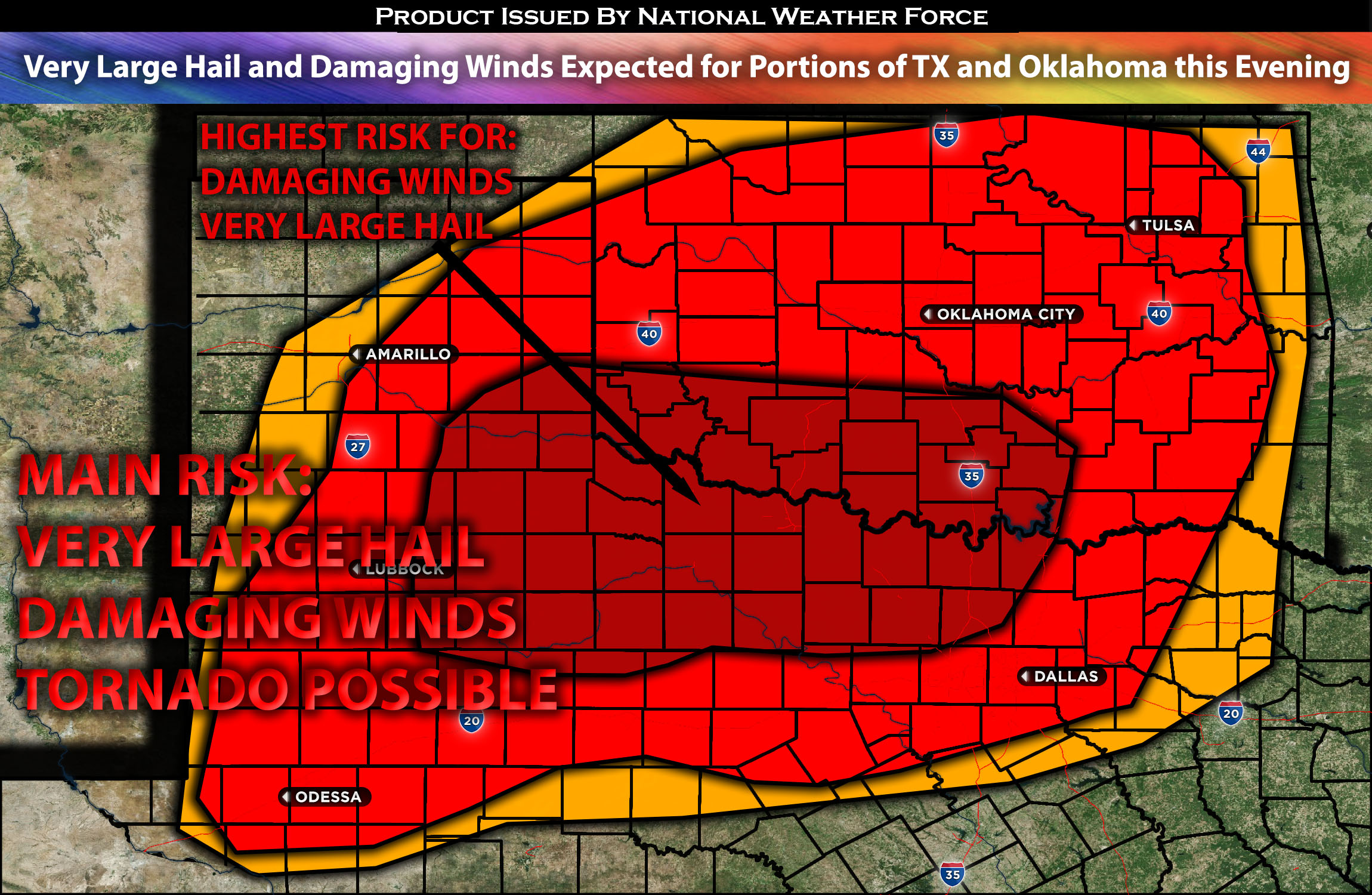
 TX Panhandle Stretching East towards Central TX and north into Western OK:
Depending on the timing of destabilization, storms are expected to develop along this boundary and temperature gradient. It’s anticipated that storms will initiate over the TX panhandle and then quickly intensify as they move northeastward. Additional storms are likely to emerge across north TX through western OK, with the potential to produce very large hail up to 2-3 inches, damaging winds, and possibly a tornado or two. The onset of these storms is projected around 2-3pm CDT in the TX panhandle, with an expansion in coverage from 3-5pm CDT across the broader area. As the evening progresses, these storms will coalesce and form a line, reaching Dallas, TX by midnight. This line may yield damaging winds and large hail, especially in isolated storm cells. In much of eastern OK, the primary concern will be heavy rain and localized strong winds due to the rapidly weakening conditions to the east.
Forecast Details:
A surface temperature gradient is set to move slowly southeastward during the first part of the day, stretching from the TX Panhandle to northwest OK. This boundary might be locally enhanced by morning weather activity in northwest OK. As the day progresses, low-level moisture will keep pushing northward. By early to mid-afternoon, dewpoints in the mid 60s to low 70s are anticipated along and south of this front, spanning from the TX South Plains to western/central OK. Excluding areas with lingering morning weather, the combination of surface heating and rising moisture will elevate instability levels to between 2500-3000 J/kg as resistance to cloud formation lessens. Storms are likely to form by early to mid-afternoon near this temperature boundary, starting from the TX South Plains and extending to western OK. These storms have the potential to generate very large hail up to 2-3 inches, cause wind damage, and perhaps even spawn a tornado or two. The likelihood of tornadic activity increases in the evening, contingent on the presence of low-level wind patterns. These storms will cluster up throughout the night as they move eastward along the cold front and the main risk becoming damaging winds perhaps gusts over 70mph at times.
Main risk: Very Large hail 2-3 inches, damaging straight-line winds, tornado possible but not main risk.
Stay tuned for more updates.
Sina⚡⚡
With over a decade of experience in forecasting severe thunderstorms, this individual is a seasoned forecaster and developer. Their expertise in severe weather forecasting and computer science is entirely self-taught, complemented by a foundation in Atmospheric Science from UNCO and an IT background from WGU. They have dedicated their efforts to developing innovative tools that enhance the accuracy of analyzing large hail and tornadoes. As a significant contributor to the National Weather Force, they have played a crucial role in providing accurate and timely information, as well as developing tools to keep those affected well-informed.
NOTE: The alerts and outlooks posted here are customary made to inform. At times, which is often, you will see an alert forecast posted on here that you do not see elsewhere. That is fine, the track record of the main office is very high so maintain to follow an event when posted. These are custom concentrated alerts and outlooks that are created by National Weather Force team of experts.
