
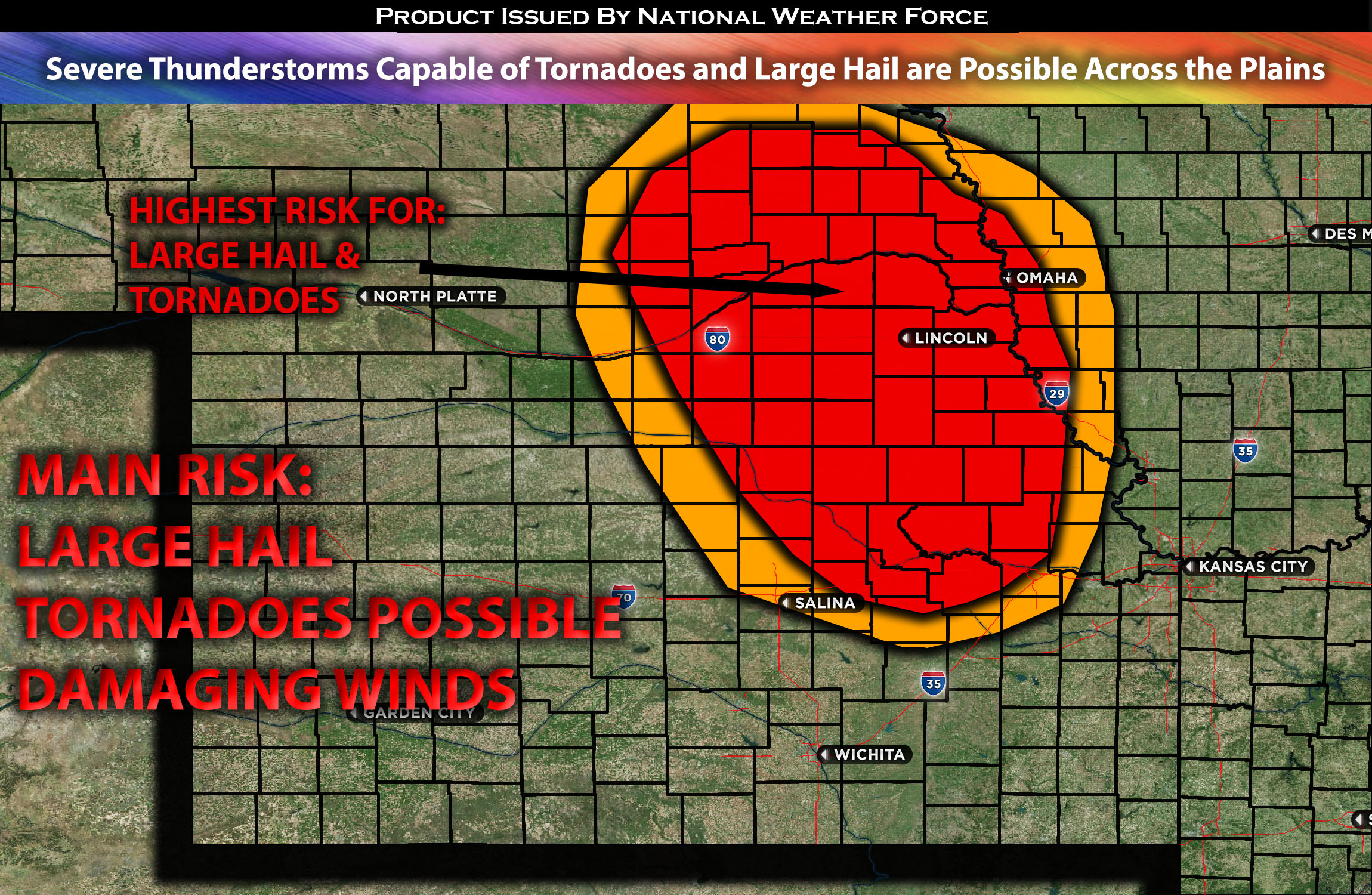
Eastern Nebraska stretching down to Northeastern Kansas:
Strong to severe thunderstorms are expected to form as early as 1pm CDT across central NE, with activity intensifying and spreading to eastern NE as the cap breaks. These storms, discrete in nature, have the potential to produce large hail, tornadoes, and damaging winds throughout the evening. This activity may persist overnight towards the east as the cold front and surface low advance eastward.
Regions At Risk: NE east cities of Omaha, Lincoln NE, NE south, KS northeast, IA west and southwest.
Forecast Details:
In the upper levels of the atmosphere, an upper-level low is set to intensify and shift eastward across the Plains. At the same time, a surface low is forecasted to be over southwest NE/northwest KS during the morning hours. This surface low will migrate eastward gradually during the day, with a quicker northeastward shift in the evening as the upper system begins to dominate the area. Historically, this type of upper-level, cold-core low often produces more concentrated severe weather due to the low pressure system that strengthens with height in accordance with the thermal wind relationships. Directly ahead of this upper low, a southwesterly mid-level jet stream, moving at speeds between 70-80 knots, is expected to gain prominence over the region. At the same time a triple point area along the south of the surface front. The main uncertainty lies in the level of instability and moisture. Nonetheless, ample vertical shear will support the development of low-top cells, especially around the warm front in northeastern NE and eastern NE more broadly. From the late afternoon into the evening, and possibly extending overnight, these storms could yield large hail and damaging winds.
Main risk: large hail, tornadoes possible, damaging winds, CG lightning, and heavy rainfall
Stay tuned for more updates.
Sina⚡⚡
With over a decade of experience in forecasting severe thunderstorms, this individual is a seasoned forecaster and developer. Their expertise in severe weather forecasting and computer science is entirely self-taught, complemented by a foundation in Atmospheric Science from UNCO and an IT background from WGU. They have dedicated their efforts to developing innovative tools that enhance the accuracy of analyzing large hail and tornadoes. As a significant contributor to the National Weather Force, they have played a crucial role in providing accurate and timely information, as well as developing tools to keep those affected well-informed.
NOTE: The alerts and outlooks posted here are customary made to inform. At times, which is often, you will see an alert forecast posted on here that you do not see elsewhere. That is fine, the track record of the main office is very high so maintain to follow an event when posted. These are custom concentrated alerts and outlooks that are created by National Weather Force team of experts.