
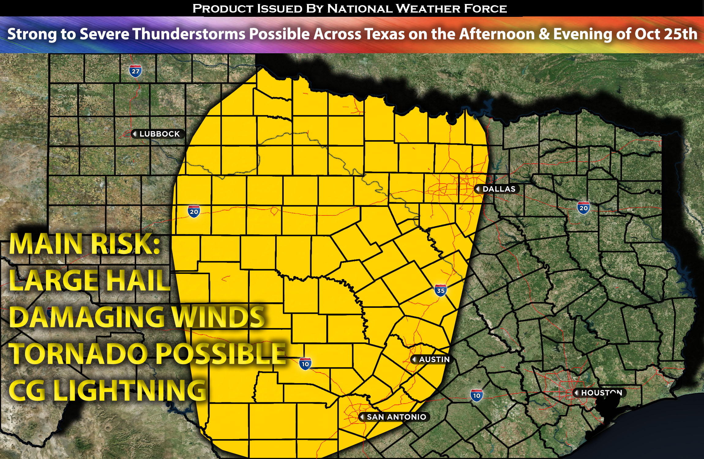
Across the TX Area:
Depending on when destabilization begins, storms are expected to form from the northern portions/panhandle of TX down to central TX. These storms are predicted to develop around 1-2pm and gradually intensify as they move eastward across the area. For areas like Dallas, the storms are expected to weaken due to the more stable airmass to the east. However, any of these storms will be capable of producing severe weather at least through the overnight hours of Wednesday into Thursday morning. Dallas is expected to be impacted from around midnight through Thursday morning, moving from west to east. The further east the storms go, the less likely they are to remain organized. They will then continue to push mainly eastward across the remaining eastern and northeastern portions of TX through Thursday morning, dissipating significantly as they go.
Regions At Risk: Texas North including Dallas TX, central area, southern portions of TX.
Forecast Details:
Overall, a mid-level flow exists across the central area of the U.S. Concurrently, a mid-level shortwave trough across the southern portions of the Rockies is expected to continue pushing eastward into the southern Plains region by mid-morning/afternoon. This, combined with a deepening surface low in a moister airmass with dew points in the mid-60s, is spreading northward across the area. However, due to the ongoing convective activity, limitations on heating will result in instability values that are less elevated. Nonetheless, sufficient mid-level shear (effective shear) with 40-45 kts flow will allow some of these storms to become severe, capable of producing large hail and damaging winds. There is also a small risk of an isolated tornado, especially given the slight uptick in low-level shear during the evening hours.
Main risk: large hail, damaging winds, isolated tornado, CG lightning, and heavy rainfall
Stay tuned for more updates.
Sina
With over a decade of experience in forecasting severe thunderstorms, this individual is a seasoned forecaster and developer. Their expertise in severe weather forecasting and computer science is entirely self-taught, complemented by a foundation in Atmospheric Science from UNCO and an IT background from WGU. They have dedicated their efforts to developing innovative tools that enhance the accuracy of analyzing large hail and tornadoes. As a significant contributor to the National Weather Force, they have played a crucial role in providing accurate and timely information, as well as developing tools to keep those affected well-informed.
NOTE: The alerts and outlooks posted here are customary made to inform. At times, which is often, you will see an alert forecast posted on here that you do not see elsewhere. That is fine, the track record of the main office is very high so maintain to follow an event when posted. These are custom concentrated alerts and outlooks that are created by National Weather Force team of experts.