
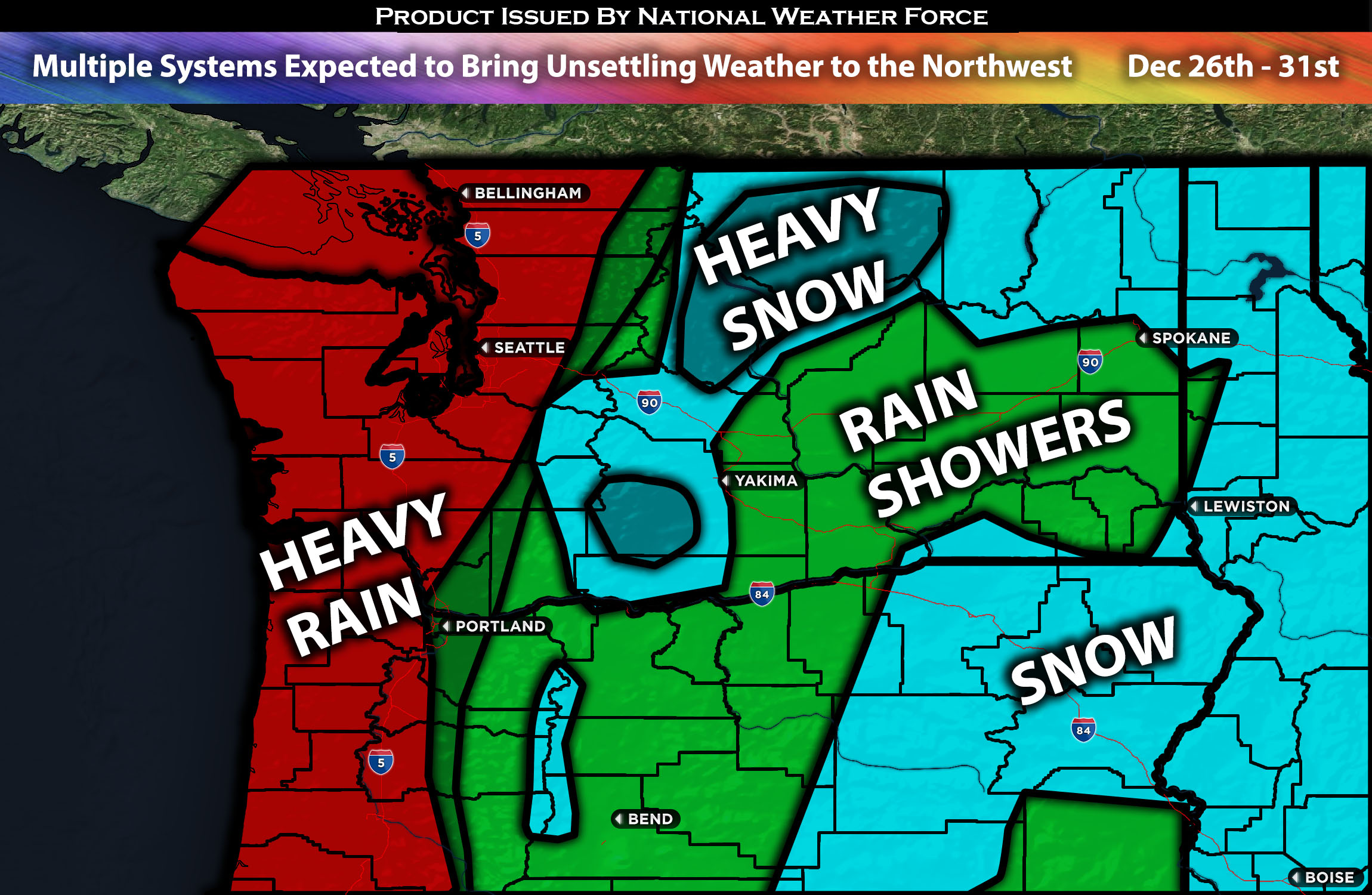
Across the Northwest:
As multiple systems are expected to impact the northwest this week, they will bring multiple rounds of heavy rain, gusty winds, and flooding concerns once again throughout the week. The first system will be pushing through tonight into tomorrow. Another system will come Wednesday into Thursday, followed by another one from Friday evening through Saturday. Some systems will be more potent than others, which, just from the re-accumulation on already saturated grounds, will cause some issues with flooding and more. The most concentrated area of rainfall looks to be around the coasts of Oregon and Washington.
Forecast Details:
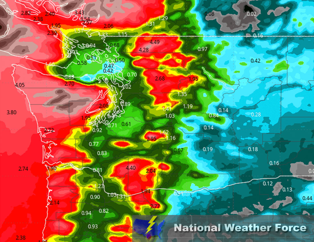
A front is expected to move across western Washington and sweep through the area, bringing rain showers for the entire region. The snow levels will be 5000-7000 ft for the most part, and slightly rise before dropping again on Tuesday to 3500 ft, given the sinking cold air near the surface. Stronger winds in the canyons may also lead to potential freezing rain in those areas. Rain showers will prevail from the northwest and move inland across the rest of the area. Then around Monday night, more widespread showers and heavy rain will move in, further sweeping through the area in an on-and-off sequence. A slight break will come on Tuesday as the first frontal system moves out, bringing more settled weather. The next system arrives around Wednesday as another trailing cold front pushes through, this time with the jet stream right over the area. This will cause the front to split across the area and into northern California. More rain showers, heavy at times, are expected with more back-to-back systems, with a stronger system approaching over the weekend around Friday evening through Saturday, bringing more rainfall and mountain snow. Another trough is also expected to move into the area on Sunday, and its potential for further strengthening will be monitored. Total rainfalls will vary more with this week however anywhere in the coastal area can see around 2-3 inches locally higher with some areas easily over 4 inches (see approximate rainfall map below).
Approximate Rainfall Totals (in inches):
Approximate Snowfall Totals (in inches):
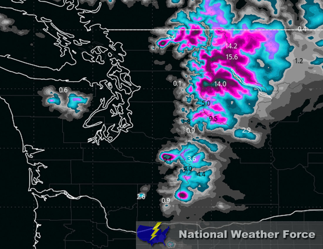
Main impact: rain heavy at times leading to potential flooding, snow heavy at times in the mountains, and gusty winds
Stay tuned for more updates.
Sina⚡⚡
With over a decade of experience in forecasting severe thunderstorms, this individual is a seasoned forecaster and developer. Their expertise in severe weather forecasting and computer science is entirely self-taught, complemented by a foundation in Atmospheric Science from UNCO and an IT background from WGU. They have dedicated their efforts to developing innovative tools that enhance the accuracy of analyzing large hail and tornadoes. As a significant contributor to National Weather Force & Southern California Weather Force, they have played a crucial role in providing accurate and timely information, as well as developing tools to keep those affected well-informed.