
Outlook for the Deep South Including the Gulf Coast Region:
All the ingredients are coming together for a potential severe weather outbreak, including all types of hazards, as a powerful system impacts the Gulf of Mexico region. Storms will have a discrete nature ahead of the front before becoming linear, capable of producing large hail, damaging straight-line winds, and tornadoes, including the possibility of a few strong ones, given the strong veering dynamics with height. As the night comes, the storm mode will become mostly linear, creating a squall line that will sweep across the South, mainly bringing damaging winds and perhaps a few embedded tornadoes as it moves across the area from west to east. For more details on the forecast, please check below.
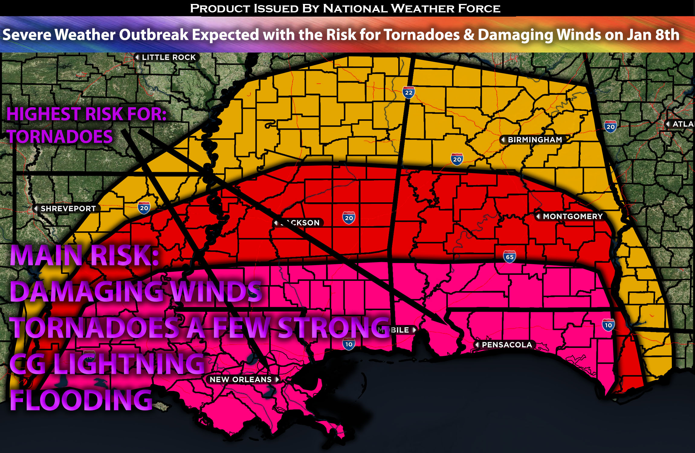
Main impact: large hail, damaging winds, tornadoes perhaps a few strong ones.
Approximate Timing: From evening through overnight, discrete cells are expected first in LA, followed by a line of strong storms sweeping across MS and AL into Tuesday morning.
Overall Forecast: In the mid and upper levels of the atmosphere, a strong positively tilted shortwave trough is expected to move into the Southern Plains. It will significantly strengthen, bringing a strong jet stream into the MS Valley region on Tuesday. Ahead of it, very strong forcing aloft is anticipated, along with very strong warm air advection at the low levels. At the surface, a low-pressure system is expected to draw in further warm moisture. This, combined with elevated instability and very strong deep layer shear and low-level shear, brings the risk of severe thunderstorms. These storms are capable of producing large hail, damaging winds, and tornadoes, with a few potentially strong ones given the strong low-level shear. The strongest shear levels will be across southwest LA, especially the coastal areas, as discrete cells impact the region on Monday evening. This is also where the warm front is expected to push upwards, right ahead of the approaching boundary.
From LA Stretching to MS & AL: Across LA and the Gulf Coast region, severe storms are anticipated to develop. This is expected as destabilization occurs around 4-5pm ahead of the front. Additionally, as the warm front pushes north, storms are anticipated to develop discretely across the region. These storms will be capable of producing all types of hazards. The strongest tornado dynamics are expected right around the LA coast, stretching to MS coastal areas and slightly inland. Moving away from the coast, the risk shifts more towards damaging winds and large hail. As the boundary moves eastward from the west, a strong squall line is expected to push through the entire MS and AL region. This squall line is capable of producing straight-line winds and perhaps a few embedded tornadoes from Monday night into Tuesday.
Stay tuned for more updates.
Sina⚡⚡
With over a decade of experience in forecasting severe thunderstorms, this individual is a seasoned forecaster and developer. Their expertise in severe weather forecasting and computer science is entirely self-taught, complemented by a foundation in Atmospheric Science from UNCO and an IT background from WGU. They have dedicated their efforts to developing innovative tools that enhance the accuracy of analyzing large hail and tornadoes. As a significant contributor to National Weather Force & Southern California Weather Force, they have played a crucial role in providing accurate and timely information, as well as developing tools to keep those affected well-informed.