
Outlook for the Southeast & Atlantic Region:
An already potent line of storms (QLCS) is continuing its eastward path, capable of producing embedded tornadoes, including a few strong ones, and damaging winds. Additionally, more discrete storms are expected to form ahead of this system across the Atlantic region. These storms are anticipated to form around the afternoon/evening hours before the cold front pushes through. For more details on the forecast, please refer to the information provided below.
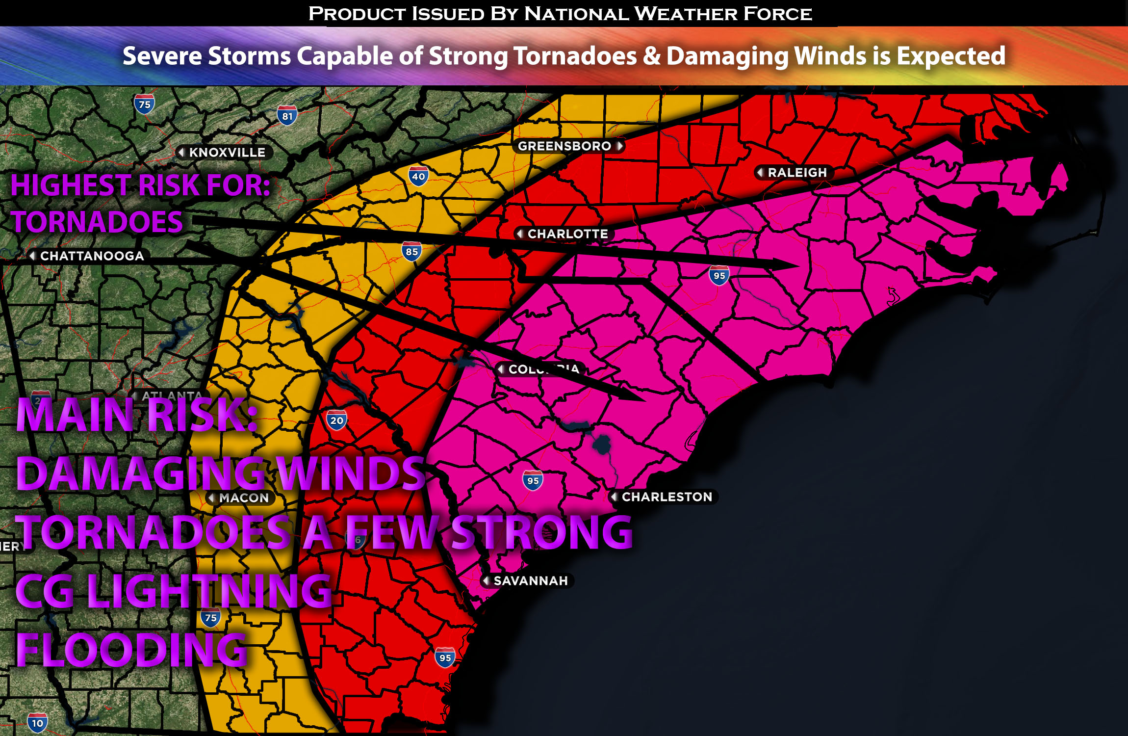
Main impact: isolated large hail, damaging winds, tornadoes perhaps a few strong ones.
Approximate Timing: Currently through the evening hours with the QLCS line pushing eastward strengthening then more discreet cells forming across the Atlantic region as destabilization occurs.
Overall Forecast: In the mid/upper levels of the atmosphere around the Central and Midwest region, a powerful cyclone, accompanied by a 100+ knot mid-level jet and low pressure, is expected to move northeastward, continuing to bring severe storms ahead of it. At the same time, at the surface, a cold front is expected to continue pushing eastward. As it overtakes the line of severe storms, further forcing will occur, enhancing the strength of the storms. Ahead of this, a prominent damaging squall line, capable of producing damaging winds and embedded tornadoes, is already making its way through the southeast. Additionally, a surface low is situated right over the AL region. Ahead of the cold front, warm air advection continues, pushing a warm front northward into the Atlantic region. By Tuesday afternoon/evening, very warm moisture, elevated instability, and very strong shear values at different levels of the atmosphere are expected, especially south of the warm front. This will allow for more discrete cells to form across the southeast and Atlantic region. Combined with very high low-level shear values, these storms will be capable of producing tornadoes, perhaps a few strong ones, and damaging straight-line winds throughout the evening before the cold front pushes through.
From GA stretching to NC: A QLCS, already associated with damaging winds and embedded tornadoes, is expected to continue moving eastward. Ahead of that, conditions are aligning for more severe storms to develop across the South Carolina and North Carolina region. This development is anticipated due to destabilization occurring around 4-5pm ahead of the front. Additionally, as the warm front pushes north, storms are anticipated to develop discretely across the region. This is especially true towards the coast and slightly more inland as well. These storms will be capable of producing all types of hazards.
Highest Tornado Risk Region: The strongest tornado dynamics are expected right around the central and eastward regions of North Carolina and South Carolina. Moving away from the coast, the risk shifts more towards damaging winds and isolated large hail.
Stay tuned for more updates.
Sina⚡⚡
With over a decade of experience in forecasting severe thunderstorms, this individual is a seasoned forecaster and developer. Their expertise in severe weather forecasting and computer science is entirely self-taught, complemented by a foundation in Atmospheric Science from UNCO and an IT background from WGU. They have dedicated their efforts to developing innovative tools that enhance the accuracy of analyzing large hail and tornadoes. As a significant contributor to National Weather Force & Southern California Weather Force, they have played a crucial role in providing accurate and timely information, as well as developing tools to keep those affected well-informed.