
 Outlook for the Arklatex and Surrounding Region:
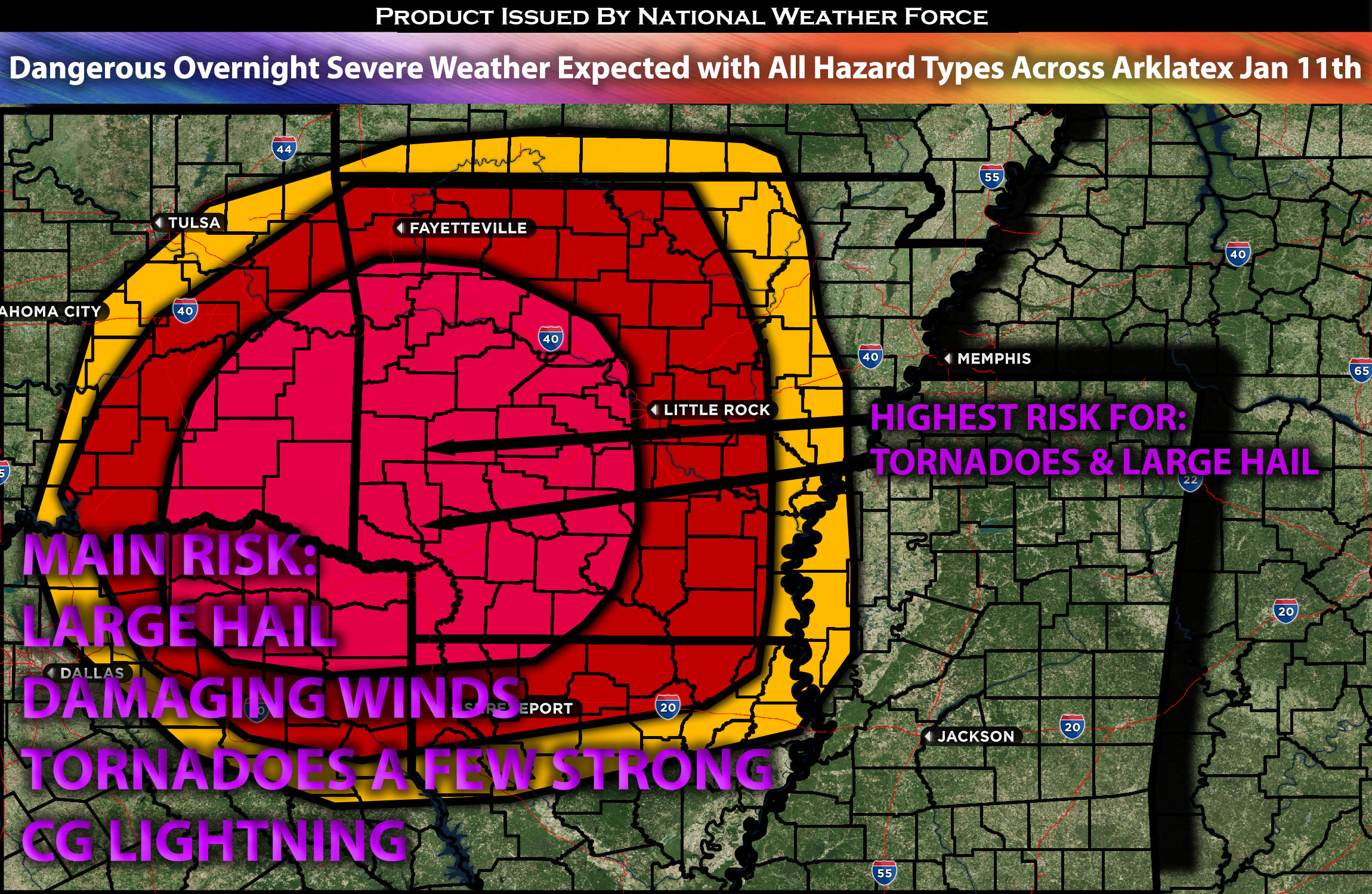
All conditions are converging later tonight and into the morning hours across the Arklatex region, making all types of weather hazards both possible and likely. These storms will be discrete in nature, with the potential for large hail exceeding 2 inches, damaging winds, and tornadoes. A few tornadoes may be strong, given the strong low-level shear. For more details on the forecast, please refer to the information provided below.
Main impact: Large Hail, damaging winds, tornadoes perhaps a few strong ones.
Approximate Timing: Expected to form around overnight into the morning hours.
Overall Forecast: In the mid/upper levels of the atmosphere, a deepening trough exhibiting cyclonic flow is expected to be negatively tilted enhancing it. This will bring a very powerful southwesterly flow and a jet stream exceeding 120 knots over the central TX area, stretching southward. Additionally, a low-level jet exceeding 65 knots will be present in this area, creating significant veering of winds with height. At the surface, a low is expected to deepen across western OK, with the flow directly over the area of focus. Combined with elevated instability, unusually high lapse rates for this time of year, and warm air advection ahead of a quasi-stationary front, this will create a highly unstable atmosphere conducive to all types of weather hazards. Discrete cells will be capable of producing large hail of 2+ inches, damaging winds, and, due to the high low-level shear, tornadoes, with a few potentially being very strong. Storms are not expected to initiate until later overnight and into the morning hours across the Arklatex region, when many people are asleep. This creates a very hazardous situation, and it’s crucial to stay tuned for updates.
From Arklatex Region: Storms are expected to start forming late tonight, between 9 pm and 12 am, as destabilization occurs. They will originate from the western AR/OK border and move northeastward, rapidly strengthening due to the robust atmospheric conditions over the area. These storms will move quickly and occur during hours when people are most likely asleep, continuing into the morning.
Highest Tornado Risk Region: The strongest tornado dynamics are expected right around the Arklatex region, including the surrounding areas, where the concentration of low-level shear and other ingredients will be.
Stay tuned for more updates.
Sina⚡⚡
With over a decade of experience in forecasting severe thunderstorms, this individual is a seasoned forecaster and developer. Their expertise in severe weather forecasting and computer science is entirely self-taught, complemented by a foundation in Atmospheric Science from UNCO and an IT background from WGU. They have dedicated their efforts to developing innovative tools that enhance the accuracy of analyzing large hail and tornadoes. As a significant contributor to National Weather Force & Southern California Weather Force, they have played a crucial role in providing accurate and timely information, as well as developing tools to keep those affected well-informed.