
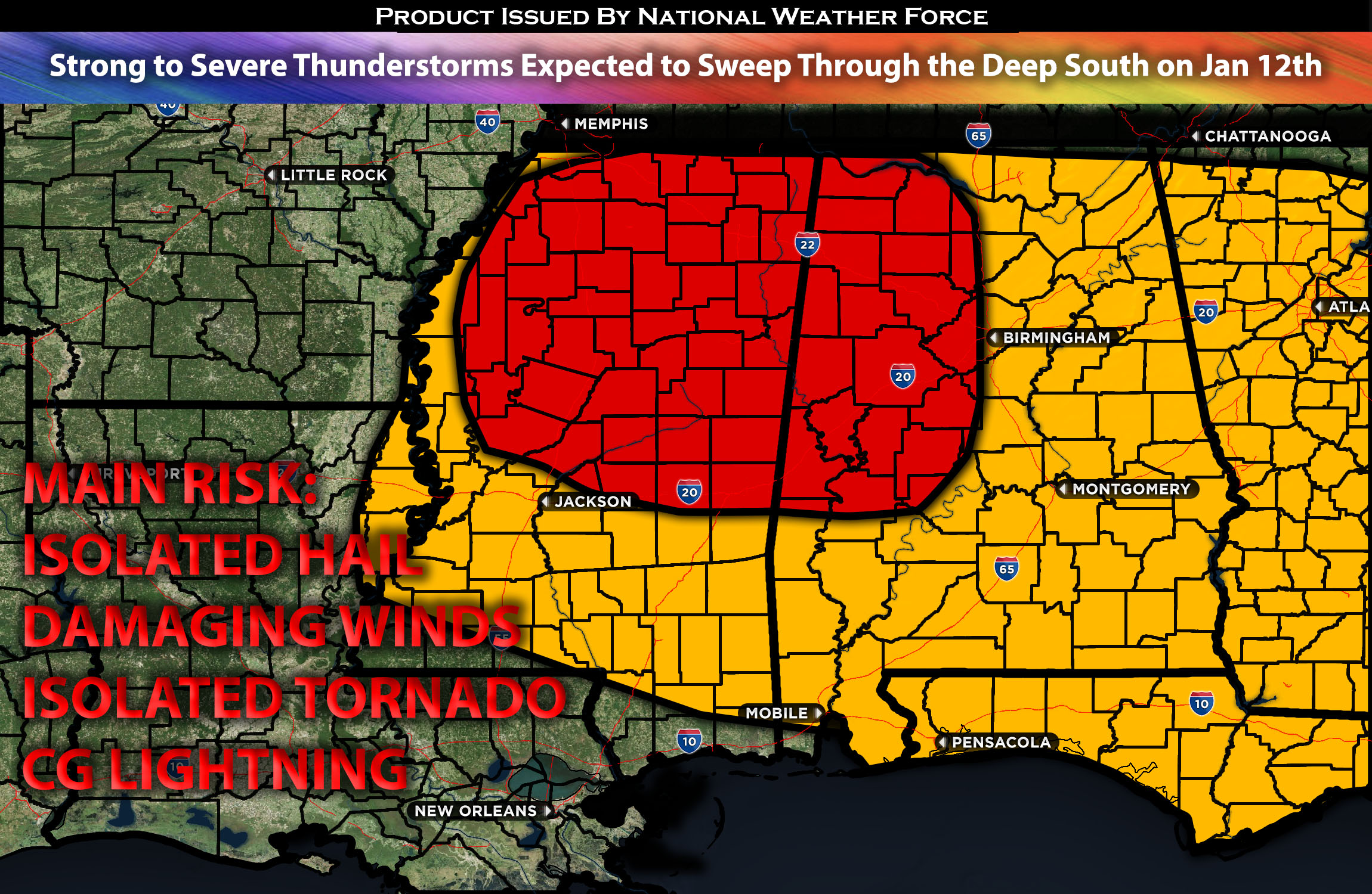
Outlook for the Northern/Central MS through the Southeast:
Strong to severe thunderstorms are likely across the Southeast, mainly over MS and into northwestern AL, before diminishing quickly due to lacking instability and buoyancy. These storms will be capable of producing isolated hail, damaging straight-line winds, and perhaps an isolated tornado, given the veering with height; however, this is limited due to buoyancy. These storms are expected to mainly impact the area throughout the morning and into the afternoon before moving eastward and diminishing. Please check below for further details on the forecast.
Main impact: isolated large hail, damaging winds, isolated tornado possible.
Approximate Timing: Expected to form around the morning hours through afternoon before the cold front pushes through quickly from west to east.
Overall Forecast: Already ongoing storms will continue from AR into neighboring states; however, due to the lack of instability, the main threat will mainly be damaging winds. On Friday morning, in the mid/upper levels of the atmosphere, a strong, enhanced shortwave trough is expected to eject into the central Plains. Along with it, a very intense jet stream with winds exceeding 120 knots can be spotted in the mid/upper level, expected to move quickly northeastward through the Mid-South and impacted regions. At the same time, a surface low is expected to be around MO, with a very fast-moving cold front expected to move through the southeast eastward through a saturated airmass with limiting instability and buoyancy. Very strong vertical shear will be in place, and effective shear, especially across MS northward and across the entire southeast, will be sufficient. However, due to the lack of instability and buoyancy storms will have a hard time becoming too organized limiting the severe potential somewhat. Only if they maintain a discrete nature will they be able to create an isolated tornado possibly, given the strong shear values. Either way, any storms that do develop will have the risk of producing potentially powerful straight-line winds perhaps an embedded isolated tornado, with a more linear expectation for storms to merge before the front pushes through and stabilizes the air.
Mainly from northern MS through AL & Southeast Possible: Storms, mainly carrying a risk for damaging straight-line winds, are expected across AR and LA Friday morning. More storms are expected to form ahead of the fast-moving cold front across northern MS and continue eastward. They will lose strength as they move across AL and the rest of the southeast. The cold front is expected to push through quickly by the afternoon. The cold front is expected to move out eastward by Friday night.
Stay tuned for more updates.
Sina⚡⚡
With over a decade of experience in forecasting severe thunderstorms, this individual is a seasoned forecaster and developer. Their expertise in severe weather forecasting and computer science is entirely self-taught, complemented by a foundation in Atmospheric Science from UNCO and an IT background from WGU. They have dedicated their efforts to developing innovative tools that enhance the accuracy of analyzing large hail and tornadoes. As a significant contributor to National Weather Force & Southern California Weather Force, they have played a crucial role in providing accurate and timely information, as well as developing tools to keep those affected well-informed.