
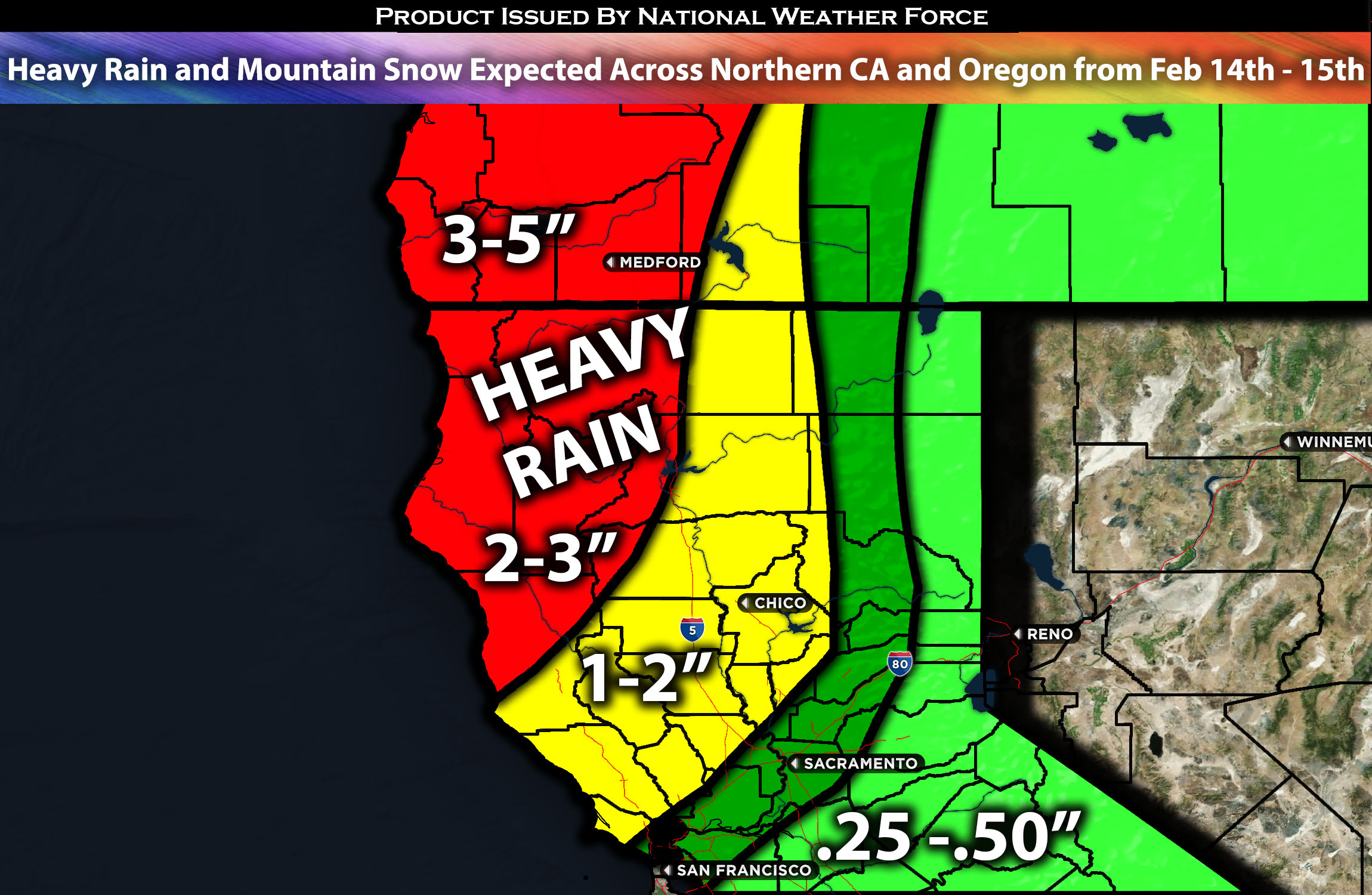
Across Northern CA and Oregon:
A moderately potent system is expected to impact the Northwest, especially northern California and Oregon, on Wednesday and Thursday. This system will bring moderate to heavy rainfall, mountain snow, and gusty winds to the area.
Overall Forecast:
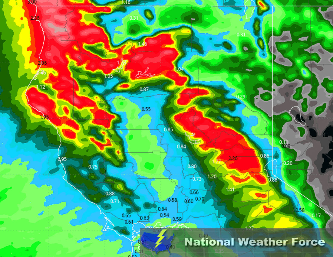
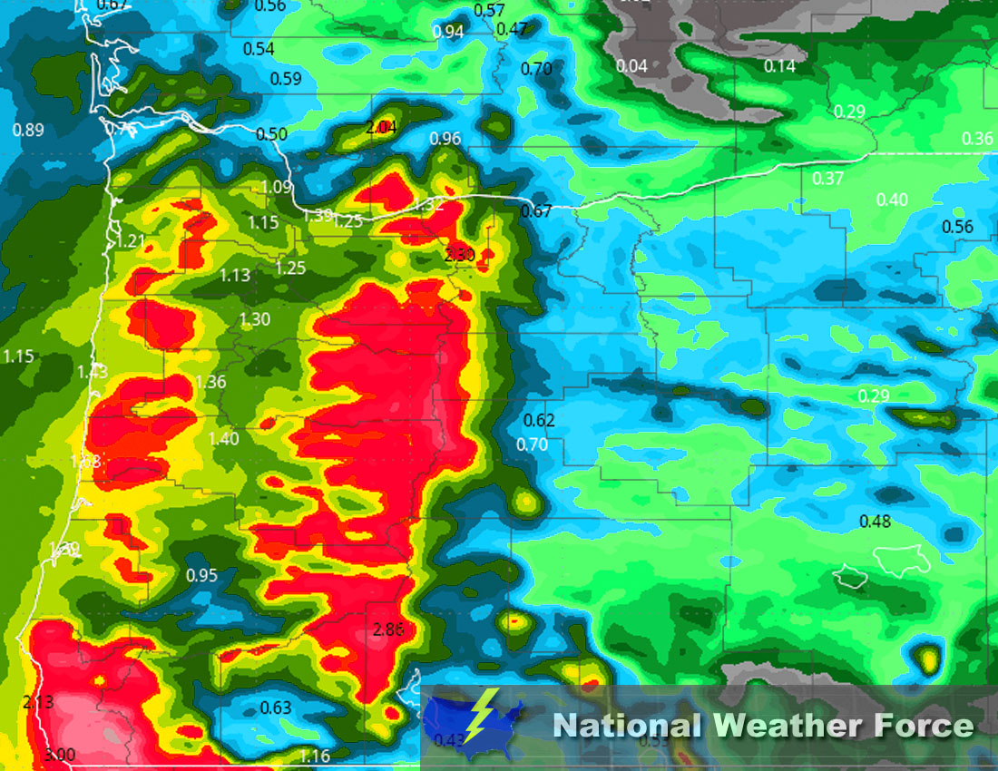
In the mid and upper levels of the atmosphere, an approaching trough is expected to push closer, eventually reaching the Oregon coast by Wednesday. At the same time, a surface warm front is expected to push northward from northern California into Oregon overnight tonight. This will initiate snow in the mountains at elevations around 5500 ft as the front pushes northward through the area. Then, an occluded front is expected to sweep through northern California from Wednesday afternoon into Thursday, moving through western portions of Oregon from west to east. As it does, it will bring somewhat deep moisture along with the trough, resulting in widespread rain and mountain snow across the area. As the front starts to push in, snow levels will be around 4500 ft, dropping to between 3500 and 3200 ft behind the front, depending on the concentration of the cooler air mass. Mountain snow will continue through Thursday with remnant moisture and a westerly flow lifting against the mountains. For more updates on the hourly forecast and further details on the timing, check below.
Timing & Impact: The warm front will first continue to push through, bringing the first wave of rain showers across the area, moving north northeastward. Then, as the front pushes slowly eastward, other more potent bands of rain, heavy at times with mountain snow, will push through. Multiple waves of rain showers will impact northern California and Oregon, moving from south to north and west to east. The strongest convective activity is expected Wednesday afternoon in extreme northern California, where a few embedded thunderstorms might also be possible around Eureka, CA giving the convective ingredients. Gusty winds especially near the coast also expected around Wednesday morning through the afternoon. These bands will continue to sweep one by one across the region of northern California, extending down into portions of central California. The further south, the lighter the rainfall amounts, with the most accumulation expected in extreme northern California and southwestern Oregon. More rounds of heavy rain showers will continue through Thursday before the system moves out by late Thursday night. Mountain snow levels will also drop behind the front, as mentioned earlier, continuing through Thursday. Check the maps for potential rainfall and snow maps below for each micro region.
Approximate Rainfall Totals (in inches):
Main impact: moderate to heavy rainfall, mountain snow, gusty winds.
Stay tuned for more updates.
Sina⚡⚡
With over a decade of experience in forecasting severe thunderstorms, this individual is a seasoned forecaster and developer. Their expertise in severe weather forecasting and computer science is entirely self-taught, complemented by a foundation in Atmospheric Science from UNCO and an IT background from WGU. They have dedicated their efforts to developing innovative tools that enhance the accuracy of analyzing large hail and tornadoes. As a significant contributor to National Weather Force & Southern California Weather Force, they have played a crucial role in providing accurate and timely information, as well as developing tools to keep those affected well-informed.