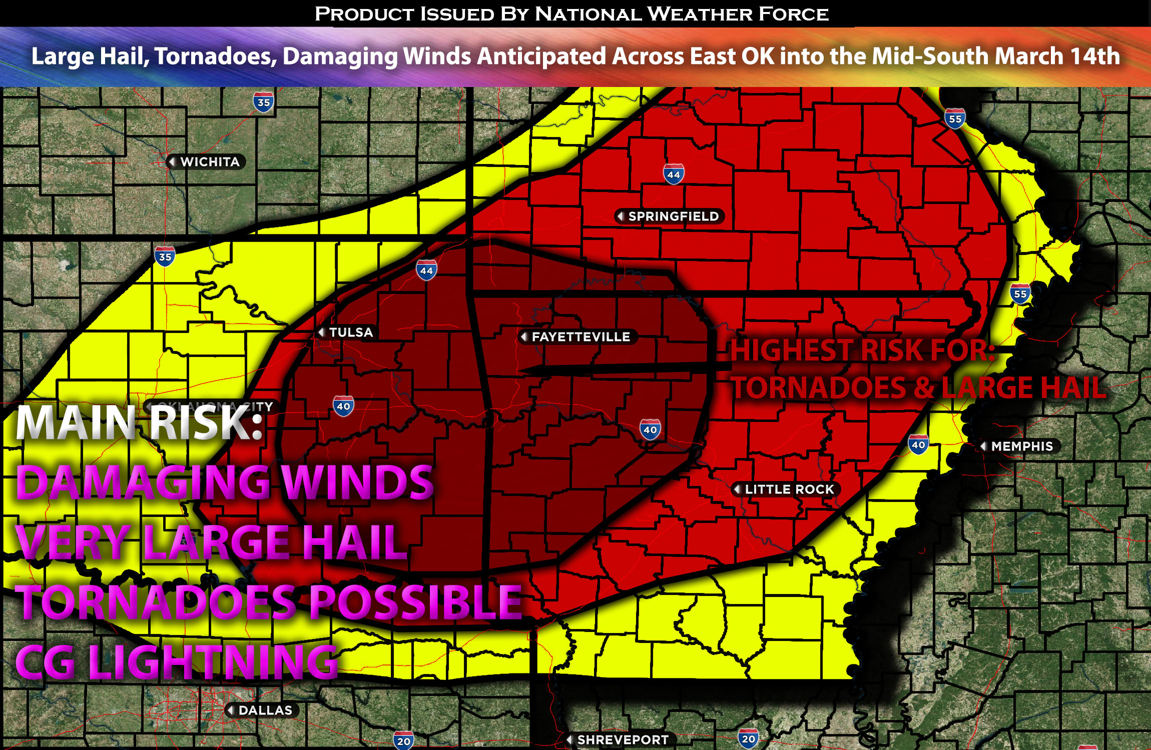
Outlook for the Eastern OK into Mid-South:
An organized severe weather risk is expected across eastern Oklahoma into the Mid-South. The combination of ingredients is anticipated to bring very severe storms capable of all severe weather hazards, with a specific concentration of tornado risk for a brief period before transitioning into a damaging wind threat overnight. Check below for more details.
Main impact: very large hail, damaging winds, and tornadoes possible (short time frame).
Approximate Timing: Depending on when destabilization can occur storms would be expected to pop around the evening hours of Thursday and continue into the overnight hours before pushing eastward. Evening hours will be the highest tornado and large hail risk before overnight transitioning to damaging winds.
Locations Impacted: Arkansas, eastern Oklahoma, central Missouri, southern Missouri, southeastern Missouri, northeastern Missouri.
Overall Forecast:
A strong southwesterly mid-level airflow, originating from a mid-level low over the Southwest, will extend northeastward across the mid Mississippi Valley and Ohio Valley. This airflow will carry a speed maximum from Kansas/Missouri to the southern Great Lakes throughout the day. By early Thursday morning, a surface low is forecast to be located near the intersection of the Nebraska, Iowa, and Missouri borders, with a cold front extending southwest through southeast Kansas and central Oklahoma into the Texas Hill Country. An east-northeast stretching warm front from this low through central Illinois is expected to be the focal point for early Thursday morning showers and thunderstorms. Ahead of the cold front, a broad warm sector with dewpoints ranging from the mid/upper 60s in the south to the low 50s near the Iowa/Missouri border will create moderate to strong buoyancy as daytime heating counteracts the stabilizing effects of early to midday cloud cover and convective activity. Consequently, thunderstorms are anticipated across much of the warm sector as the cold front gradually moves eastward throughout the day.
The large-scale lifting force over the region will be uncertain, with neutral to slightly rising mid-level heights through the early evening. Strong destabilization is forecast from north Texas into eastern Oklahoma and southwest Missouri by mid to late afternoon. Given the presence of robust buoyancy and moderate vertical shear, the initial storm development is expected to be supercellular, capable of all severe hazards. A heightened risk for severe storms, particularly tornadoes, is expected in the Arkansas area, where low-level shear will peak in the evening hours, especially in northwest Arkansas. Over time, the increasing alignment of the deep-layer shear vector with the anticipated orientation of the MCS is likely to result in a complex convective mode evolution into the overnight hours as it moves eastward.
Impact:
Multiple waves of storms are expected across the region, with ongoing storms anticipated through the Missouri area down into Arkansas before diminishing. Clearing is expected with more destabilization in the evening/overnight, where the most concentrated risk will be for all types of hazards. Storms will develop quickly and initially strengthen rapidly from eastern OK, remaining discrete within a specific timeframe in the evening before merging and becoming an MCS. This system will move eastward overnight into eastern Arkansas and into neighboring states by the morning hours, with the main risk being damaging winds.
Stay tuned for more updates.
Sina⚡⚡
With over a decade of experience in forecasting severe thunderstorms, this individual is a seasoned forecaster and developer. Their expertise in severe weather forecasting and computer science is entirely self-taught, complemented by a foundation in Atmospheric Science from UNCO and an IT background from WGU. They have dedicated their efforts to developing innovative tools that enhance the accuracy of analyzing large hail and tornadoes. As a significant contributor to National Weather Force & Southern California Weather Force, they have played a crucial role in providing accurate and timely information, as well as developing tools to keep those affected well-informed.
