
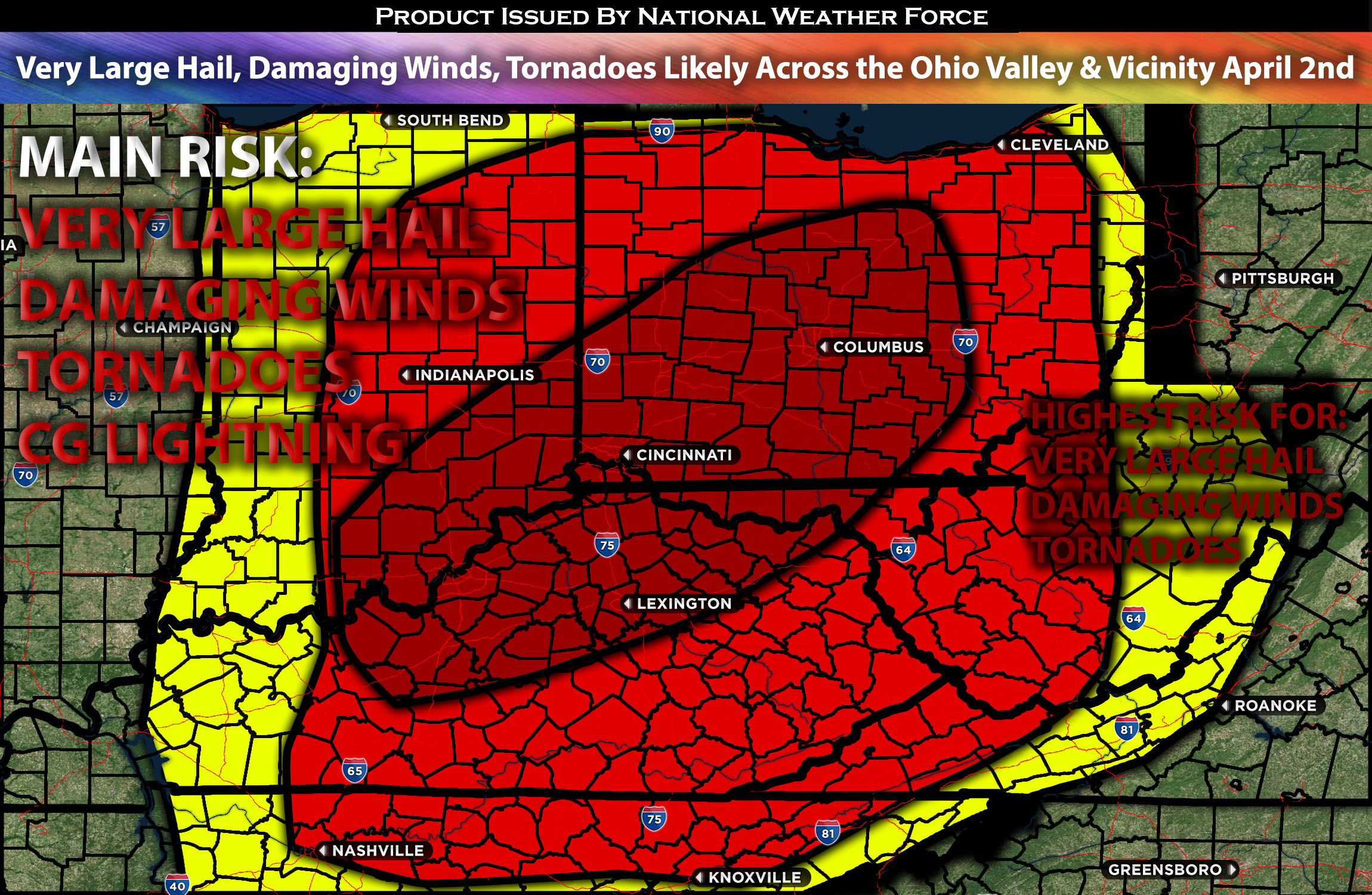
Outlook Across the Ohio and Tennessee Valley:
A significant severe weather outbreak, including tornadoes, large hail, and destructive winds, is expected for late Tuesday afternoon and evening, continuing overnight. The highest risk area is centered over the Ohio vicinity, extending southward across the Tennessee Valley.
Overall Forecast:
As a positively tilted upper trough traverses the central third of the country, a more compact and energetic short-wave feature is anticipated to move aggressively and quickly southeastward across the Upper Midwest, eventually evolving into a closed low.
A surface low initially located near Missouri is expected to deepen as the upper system descends southeastward, moving northeastward across the Midwest throughout the day and then occluding northward into Lower Michigan overnight. A cold front associated with this low will sweep across Lower Ohio Valley during the day and across the Lower Mississippi, Tennessee, and Upper Ohio Valleys overnight, crossing the central and southern Appalachian Crest late. A warm sector is anticipated to extend as far north and east as central and northeast Indiana, northern Ohio, and western Pennsylvania, with its northward expansion limited to West Virginia, northern Virginia, and Maryland due to persistent and slow-to-retreat cold-air damming over the Northeast. Severe storms capable of all hazard types are expected, with storm formation anticipated across the Ohio Valley and surrounding states.
As the surface low intensifies and crosses Illinois and later Indiana, with the cold front pushing across the Lower Ohio Valleys, storm redevelopment is expected during the afternoon and into the evening. Storms are likely to be both discrete and form clusters/linear arrangements throughout the late afternoon and evening before transitioning into a more clustered or QLCS formation. Very strong and veering deep-layer flow will support the potential for all-hazards severe weather, including very large hail, damaging winds, and several tornadoes, possibly including a strong one, particularly during the peak period in the evening.
Main impact: very large hail, destructive damaging winds, tornadoes possible and CG lightning.
Approximate Timing: Depending on when destabilization occurs, sometime around the afternoon to early evening hours, severe storms are expected to form as a cluster with discrete cells within them, capable of producing all types of hazards, especially in the Ohio vicinity. This is concentrated around the borders of Ohio, Kentucky, and Indiana, where the highest concentration of ingredients will be during the evening hours. These storms will move eastward and northeastward across the area.
Locations Impacted: Southeast Indiana, Southwest Ohio, South Ohio, Southeast Ohio, Central Ohio, North Ohio, Northeast Ohio, Northwest Ohio, Northwest Kentucky, North Kentucky, Northeast Kentucky, Central Kentucky, Southwest Kentucky, South Kentucky, Southeast Kentucky, Central Kentucky including the surrounding vicinity.
Stay tuned for more updates.
Sina⚡⚡
With over a decade of experience in forecasting severe thunderstorms, this individual is a seasoned forecaster and developer. Their expertise in severe weather forecasting and computer science is entirely self-taught, complemented by a foundation in Atmospheric Science from UNCO and an IT background from WGU. They have dedicated their efforts to developing innovative tools that enhance the accuracy of analyzing large hail and tornadoes. As a significant contributor and partner at National Weather Force Innovations LLC, they have played a crucial role in providing accurate and timely information. Additionally, they have been instrumental in developing tools and organizing projects that focus on accuracy and performance, ensuring those affected are well-informed.