
 Outlook Across the Centra Plains:
This afternoon and early evening, the central Plains could experience severe storms as unstable airmass is expected. These storms may bring severe wind gusts, isolated instances of hail, and the possibility of an isolated tornado. Check below for further details.
Overall Forecast:
A low-pressure system is anticipated to traverse the western U.S. and position itself in the central U.S. by Saturday. This upper-level low is expected to intensify, featuring a jet stream with speeds over 100 knots across the southern High Plains. On the ground, a developing low will move into the central Plains later in the period, accompanied by an eastward-moving cold front across the central and southern Plains. Surface cyclogenesis is also forecast for the afternoon across the Plains. Despite limited moisture, daytime heating and steep atmospheric temperature gradients aloft will lead to modest afternoon destabilization. Marginal instability is predicted to form ahead of the developing surface low, stretching from southwestern Nebraska east-southeastward through northern Kansas and down into the southern Plains. By mid-afternoon, low-topped storm development is expected near the surface low and along the cold/occluded front extending east-southeastward across southern Nebraska. Initially, storms may start off as individual cells but are likely to merge into an arcing line, possibly extending southward into eastern Oklahoma and northeastern Texas.
The presence of strongly backed low-level flow, which veers with altitude, will create conditions conducive to rotating updrafts, especially across the Nebraska risk area. Here, locally damaging wind gusts and large hail around 1-2 inches may occur between the late afternoon and early evening, along with the potential for an isolated tornado. However, the tornado threat is expected to be limited due to the lack of moisture and the given dynamics.
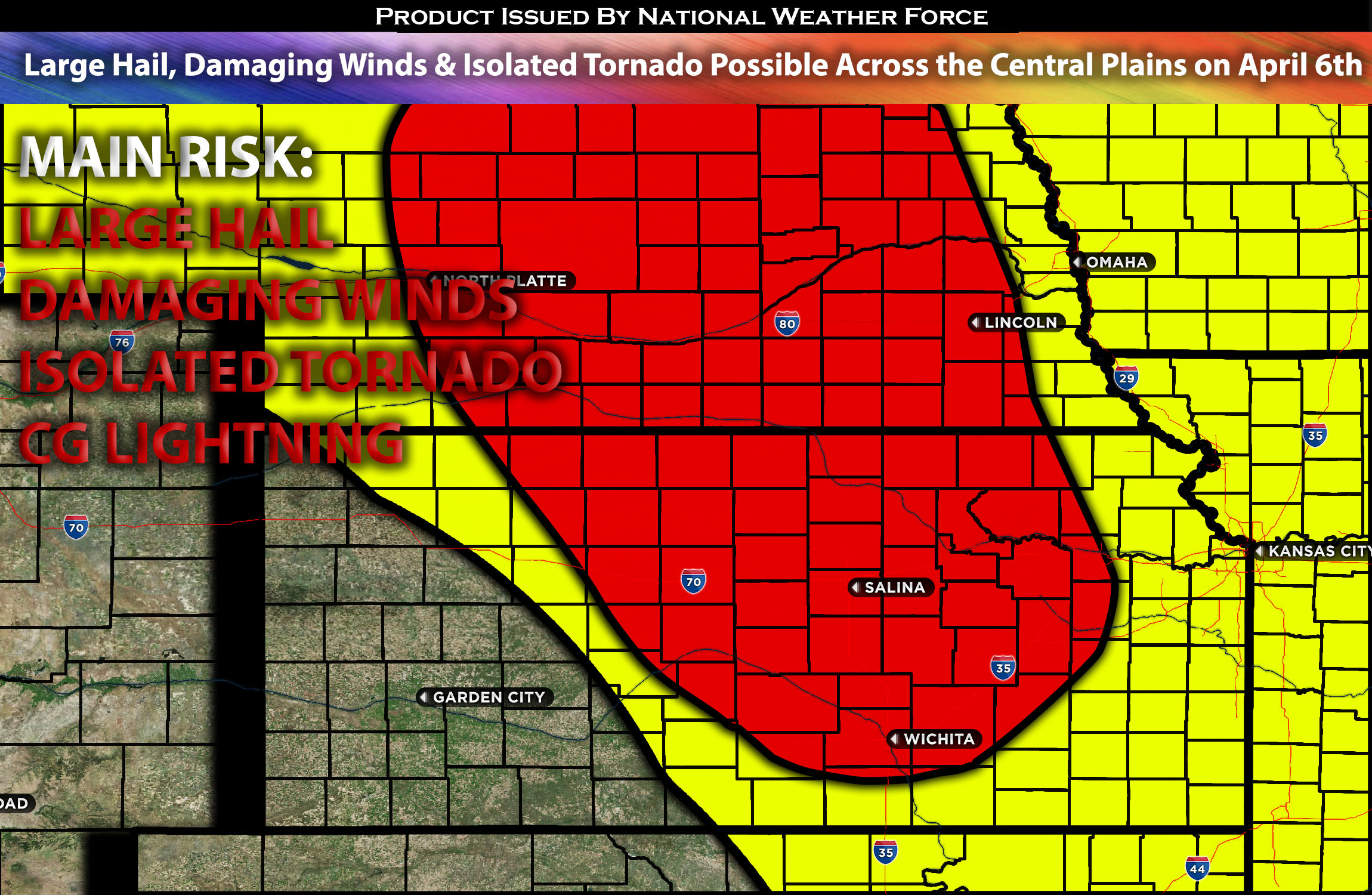
Main impact: spotty large hail, damaging winds, isolated tornado possible (low risk) and CG lightning.
Approximate Timing: Depending on when destabilization occurs, likely around the late afternoon to early evening hours, severe storms are expected to form predominantly in a linear cluster due to the immediate collision of storms after forming, with discrete cells within them. These storms are anticipated to move northeastward across the region, capable of producing spotty large hail, damaging winds, and perhaps an isolated tornado (though the risk is low due to moisture limitations). The concentrated area for any severe storms appears to be northern Kansas into the southern portions of Nebraska. A more stable air mass is expected in the late evening, causing severe storms to dissipate quickly into the overnight hours as they move north-northeastward.
Locations Impacted: Central Kansas, Northern Kansas, Southwestern Nebraska, Southern Nebraska, Central Nebraska.
Stay tuned for more updates.
Sina⚡⚡
With over a decade of experience in forecasting severe thunderstorms, this individual is a seasoned forecaster and developer. Their expertise in severe weather forecasting and computer science is entirely self-taught, complemented by a foundation in Atmospheric Science from UNCO and an IT background from WGU. They have dedicated their efforts to developing innovative tools that enhance the accuracy of analyzing large hail and tornadoes. As a significant contributor and partner at National Weather Force Innovations LLC, they have played a crucial role in providing accurate and timely information. Additionally, they have been instrumental in developing tools and organizing projects that focus on accuracy and performance, ensuring those affected are well-informed.