
 Outlook for the Southern Plains:
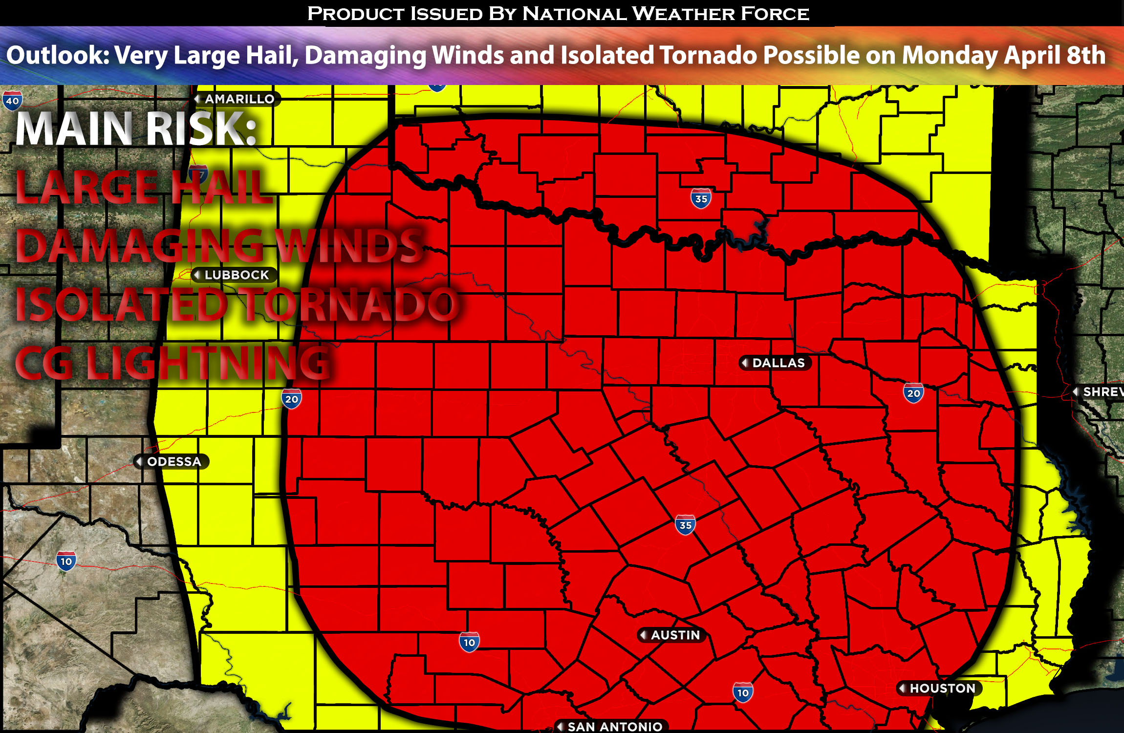
From early Monday afternoon throughout the day/night, several instances of severe thunderstorms are forecast across a broad area, including much of Texas, southern Oklahoma, southwest Arkansas, and western Louisiana. The primary concern with these storms is the potential for large to very large hail, damaging winds, perhaps an isolated tornado. For preliminary forecast check below for details.
Preliminary Outlook:
In the upper atmosphere, a low-pressure will be situated over the Midwest, accompanied by a separate shortwave trough moving across the Southwest (assisting with lift). Throughout this period, low-level warm advection will continue across the south-central states. The primary low-level jet stream is expected to extend from the northwest Gulf across eastern Texas and Louisiana. By the end of the period, mid-level height decreases associated with the Southwest trough are anticipated to spread over the west Texas vicinity. Additionally, a dryline/boundary will be present across west Texas through the southwest Oklahoma area during the evening and overnight hours. Meanwhile, low-level warm advection will be especially pronounced across Texas, particularly its western parts, originating from the Gulf of Mexico. This scenario, together with mid-level steep lapse rates, effective shear from the low-level jet, and moderate instability, sets the stage for severe storms capable of producing very large hail, damaging winds, and potentially a few isolated tornadoes. The next update will provide more detailed information, with a focus on specific areas of concern.
Potential risk: large hail, damaging straight-line winds, isolated tornadoes possible.
Stay tuned for the next update, which will provide timing details, more specific information on impacted locations, and threats for specific micro-zones in the coming day.
Sina⚡⚡
With over a decade of experience in forecasting severe thunderstorms, this individual is a seasoned forecaster and developer. Their expertise in severe weather forecasting and computer science is entirely self-taught, complemented by a foundation in Atmospheric Science from UNCO and an IT background from WGU. They have dedicated their efforts to developing innovative tools that enhance the accuracy of analyzing large hail and tornadoes. As a significant contributor and partner at National Weather Force Innovations LLC, they have played a crucial role in providing accurate and timely information. Additionally, they have been instrumental in developing tools and organizing projects that focus on accuracy and performance, ensuring those affected are well-informed.