
 Outlook Across Texas:
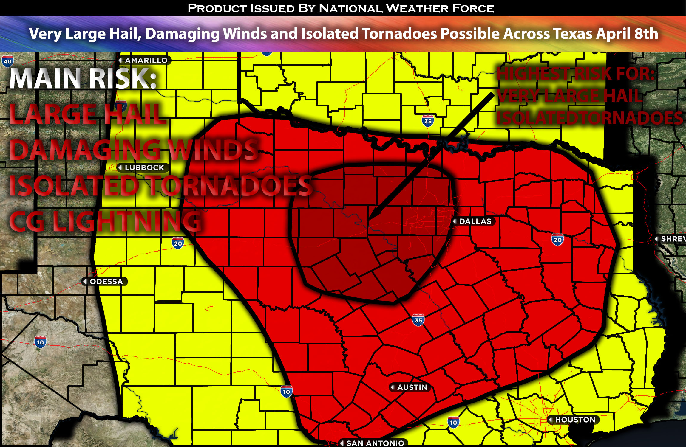
From early Monday afternoon throughout the day and night, several instances of severe thunderstorms are expected across a broad area, especially in western/northern TX, including much of Texas. The primary concerns with these storms are the potential for large to very large hail, damaging winds, and isolated tornadoes. Please check below for further details on timing and impact.
Overall Forecast:
As a positively-tilted mid-level trough amplifies and moves across the Southwest, a broad area will experience moderate mid-level southwesterly flow across Texas. A weak surface cyclone is expected to form in West Texas and intensify throughout the period. Concurrently, the remnant front in southeast Texas from early this morning will begin to move northward as a warm front during the day, bringing mid-60s dewpoints as far north as the Texas/Oklahoma border by the evening. A cold front moving south through the central Plains this morning will intersect with this warm front by late afternoon or early evening around northern Texas, near the Oklahoma border, and become stationary. This convergence will mark the northern boundary of significant destabilization, with severe storms expected to develop as a result. Combined with strong effective shear and instability, these storms will be capable of producing large to very large hail, damaging winds, and isolated tornadoes.
Main impact: very large hail, damaging winds, isolated tornadoes, and CG (cloud to ground lightning).
Approximate Timing: Depending on when destabilization occurs, likely around the late afternoon to early evening hours, severe storms are expected to form, initially isolated and predominantly in a cluster with the highest risk for large hail and isolated tornadoes. Initially, cells are likely to form on both the west and east sides of Dallas, with the cells from the west maturing and moving quickly eastward, potentially becoming an MCS as they sweep across Dallas, TX, overnight along with the boundary. Additionally, a few storms are expected to form around Dallas, TX, with scattered activity anticipated by late afternoon before the boundary and the potential MCS move through. As the storms collide and become linear, the main risk will transition towards damaging straight-line winds and possibly an embedded tornado. The line is expected to move out through Tuesday morning across northern TX.
Locations Impacted: Western TX, Northern TX and Eastern TX.
Stay tuned for more updates.
Sina⚡⚡
With over a decade of experience in forecasting severe thunderstorms, this individual is a seasoned forecaster and developer. Their expertise in severe weather forecasting and computer science is entirely self-taught, complemented by a foundation in Atmospheric Science from UNCO and an IT background from WGU. They have dedicated their efforts to developing innovative tools that enhance the accuracy of analyzing large hail and tornadoes. As a significant contributor and partner at National Weather Force Innovations LLC, they have played a crucial role in providing accurate and timely information. Additionally, they have been instrumental in developing tools and organizing projects that focus on accuracy and performance, ensuring those affected are well-informed.