
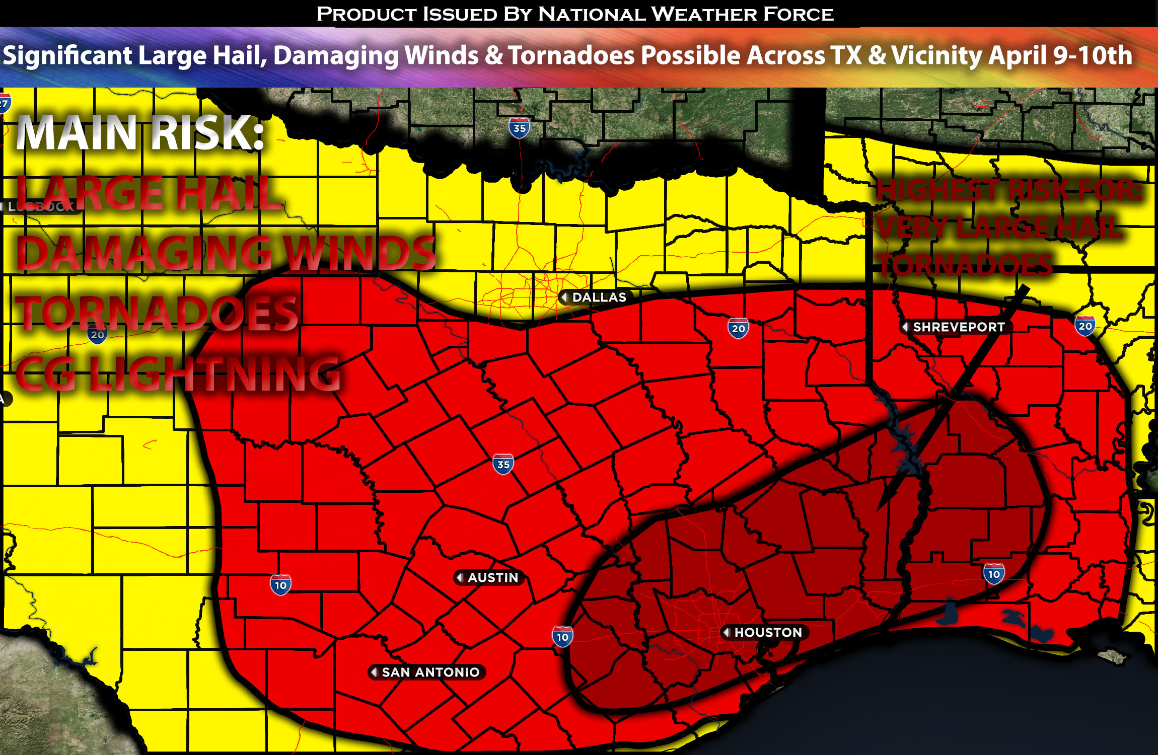
Outlook Across Majority of TX (Especially Southeast) Stretching to LA:
From Tuesday through Wednesday morning, severe thunderstorms are anticipated across a broad swath from most of Texas to the Lower Mississippi River Valley. Storms will be capable of producing a few tornadoes, significant large hail and damaging winds. Please check below for further details on timing and impact.
Overall Forecast:
An upper low is expected to remain stationary over parts of Arizona/New Mexico, trapped by ridging on both the western and eastern sides, which prevents it from moving. Eventually, the low is projected to make a steady eastward progression, crossing West Texas by Tuesday evening after being stationary, and bringing continuous severe storms to the area. This movement is complicated by several leading disturbances within the southwesterly flow ahead of the system, spreading across the south-central U.S. simultaneously.
On the ground, an outflow-reinforced warm front is expected to extend from central Texas east-northeastward to the vicinity of the Louisiana/Arkansas border. Meanwhile, a different front will shift eastward across western Texas throughout the day, with storms forming ahead of it and reaching southeastern/eastern TX overnight, and then moving into LA and nearby areas by Wednesday morning. This scenario, coupled with warm advection ahead of the front and very steep lapse rates (change in temperature with height), along with very strong instability, will facilitate the formation of clusters of severe storms across the region. As the boundary pushes east and situates around the southeast LA/TX area, it is anticipated to encounter a stronger environment with higher levels of low-level shear from the low-level jet and better dynamics for all hazard types, including tornadoes, particularly affecting the extreme southeastern TX/LA area overnight/early morning.
Main Risk: very large hail, damaging winds, tornadoes possible, and CG (cloud to ground lightning).
Approximate Timing: Ongoing storms are anticipated across the majority of Texas, resulting from lingering storms and more storms forming ahead of the system/boundary from the early morning hours into the afternoon. Then, a more concentrated setup is anticipated overnight into Wednesday morning. Depending on when destabilization occurs, severe storms are expected to form, initially isolated and predominantly in clusters, with the highest risk for large hail and tornadoes in southeastern Texas stretching into the western Louisiana area.
Locations Impacted: majority of Texas, especially southeastern TX, western LA, northern LA, and central LA.
Stay tuned for more updates.
Sina⚡⚡
With over a decade of experience in forecasting severe thunderstorms, this individual is a seasoned forecaster and developer. Their expertise in severe weather forecasting and computer science is entirely self-taught, complemented by a foundation in Atmospheric Science from UNCO and an IT background from WGU. They have dedicated their efforts to developing innovative tools that enhance the accuracy of analyzing large hail and tornadoes. As a significant contributor and partner at National Weather Force Innovations LLC, they have played a crucial role in providing accurate and timely information. Additionally, they have been instrumental in developing tools and organizing projects that focus on accuracy and performance, ensuring those affected are well-informed.