
 Across the Deep South:
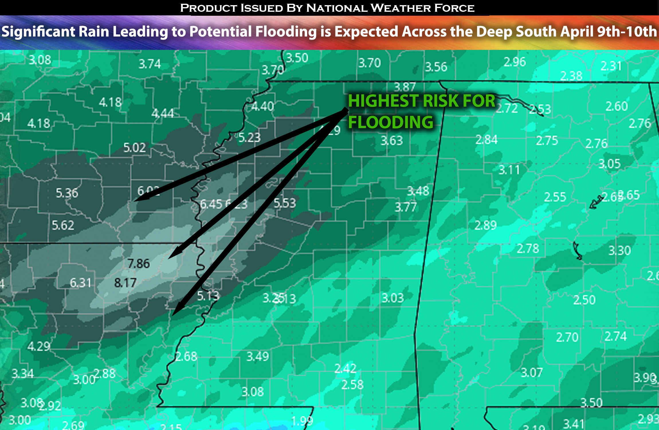
A powerful system expected to bring not only severe weather across the area but also to push very deep moisture into the impacted regions is raising concerns about flooding. Very heavy rain is anticipated over multiple days, with storms forming over the same areas, causing flooding. Check the overall forecast for further specific details.
Overall Forecast:
Expect an uptick in convective activity across the Deep South, driven by the influence of a strong mid and upper-level trough approaching. This trough is forecast to swing eastward from the Southwestern US into West Texas by Tuesday afternoon, bringing with it an intensified flow ahead of the main trough axis. Early indications suggest a substantial wave of heavy rain hitting Northern and Central Texas in the morning, then moving eastward into the ArkLaMiss area before tapering off in the late afternoon. Following this, a secondary increase in convective activity is anticipated for the early evening as the trough axis moves northeast and adopts a negative tilt upon reaching the Red River. This shift will notably alter the flow in the Lower Mississippi Valley, with an enhanced low-level jet channeling rich Gulf moisture across a vast stretch of the Southeastern US to the Tennessee Valley. An anticipated shortwave ejection in front of the main trough is poised to spur a swift onset of convection over East Texas, culminating in a widespread heavy rain scenario across Louisiana, Arkansas, and Mississippi by nightfall.
There is a substantial expectation of receiving over 3 inches of rain across a wide region, peaking at around the northeast Louisiana/southeast Arkansas border. This aligns with the 500mb level developments and the North Texas boundary orientation. Given this, a significant swath of 3+ inches is anticipated over Northern Louisiana into the ArkLaMiss region.
Timing & Impact:
Very heavy rainfall is expected to be underway at the start of Tuesday morning, continuing into the daytime hours through Wednesday, with the bulk occurring on Tuesday. The atmospheric flow aloft will become increasingly divergent east of an approaching deep-layer trough and closed low, while moisture from the Gulf is pulled northward. At the same time, the surface front north of the ArkLaTex to ArkLaMiss corridor will slowly drift southward. This movement, supported by frontogenesis from the northern stream jet streak, will sustain widespread rainfall with recurrent convection and higher rainfall rates in many of the same areas.
Sina⚡⚡
With over a decade of experience in forecasting severe thunderstorms, this individual is a seasoned forecaster and developer. Their expertise in severe weather forecasting and computer science is entirely self-taught, complemented by a foundation in Atmospheric Science from UNCO and an IT background from WGU. They have dedicated their efforts to developing innovative tools that enhance the accuracy of analyzing large hail and tornadoes. As a significant contributor and partner at National Weather Force Innovations LLC, they have played a crucial role in providing accurate and timely information. Additionally, they have been instrumental in developing tools and organizing projects that focus on accuracy and performance, ensuring those affected are well-informed.