
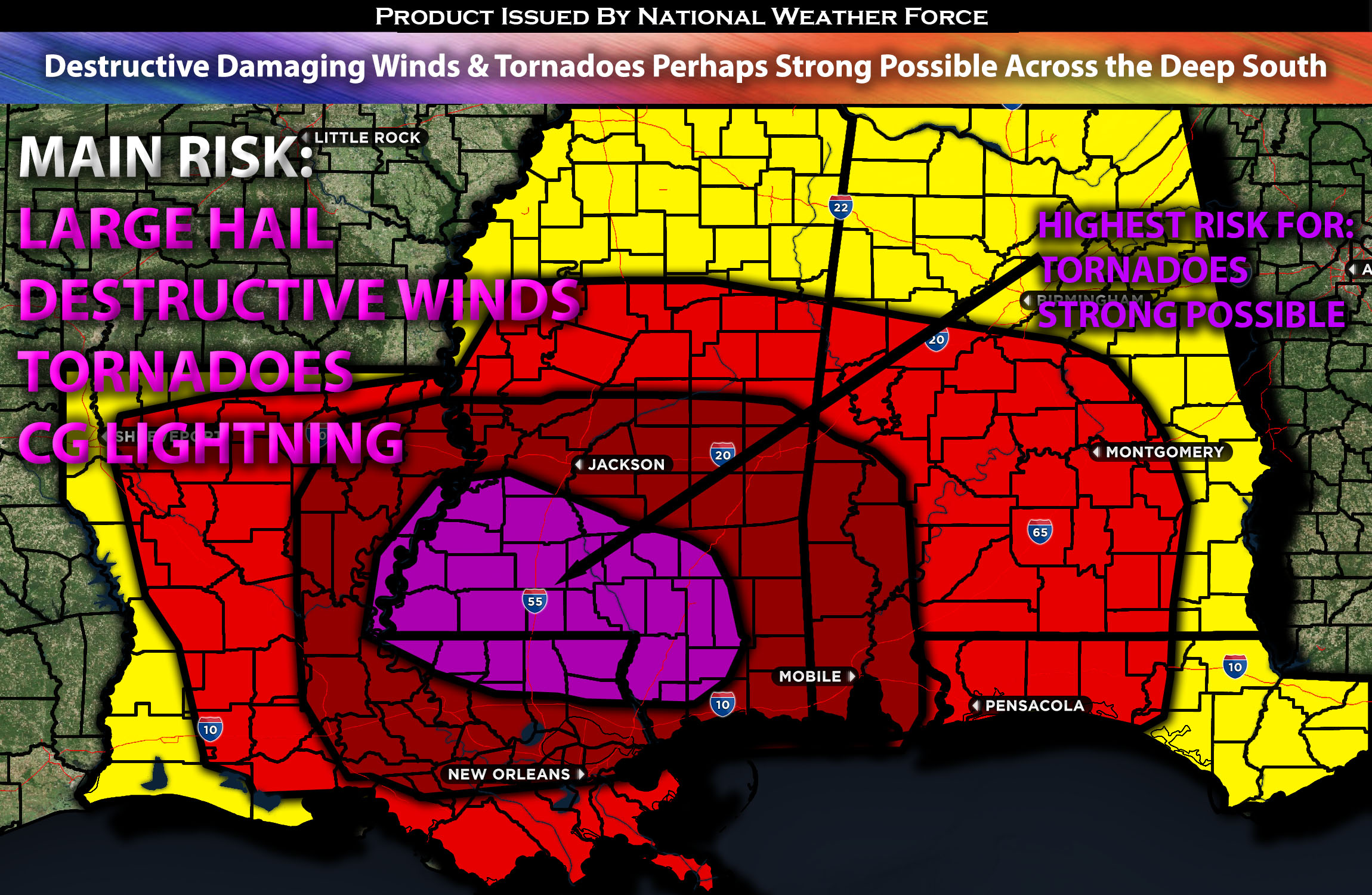
Outlook Across the Central Deep South:
Severe storms are expected to sweep across the central Gulf Coast States, particularly in the southern regions, due to a complex mix of contributing factors concentrated there. The environment is ripe for the formation of several tornadoes, with a few potentially becoming strong, but this is contingent on the development of discrete cells within areas of very strong shear. Additionally, the main squall line could bring widespread damaging winds, some of which might cause significant damage, and large hail is also a risk, especially within those discrete cells. Please check below for further details on timing and impact.
Overall Forecast:
The upper low, which has been triggering severe storms across Texas, will shift eastward across Northern Texas during the day and transition into an open wave by late afternoon/evening as it approaches the ArkLaTex region. In advance of the upper trough, a cool air mass aloft will steadily move east towards the Lower Mississippi Valley, accompanied by increasing mid-level southwesterly winds of 70 knots. As the upper wave progresses, it will diminish in strength by Thursday morning upon nearing the Appalachians. Simultaneously, a southerly low-level jet, initially at 50 knots, will strengthen to 70 knots over the period, enhancing both shear and moisture advection ahead of the boundary. This will lead to a highly unstable air mass conducive to all types of severe weather hazards, including tornadoes, particularly in a specified region southward where discreet cells are possible.
Currently around sunrise, a squall line is expected near the Texas/Louisiana border and is set to move east throughout the day within a highly sheared environment. This linear storm band is anticipated to cause widespread damaging winds. As the boundary layer warms, discrete supercells may develop ahead of the main squall line, significantly increasing the risk for potential tornadoes. The presence of strong low-level shear could facilitate the development of a few strong tornadoes, provided that conditions sufficiently evolve. Given the heavy precipitation already occurring across the northern Gulf States, the primary area for severe weather is expected to extend across Louisiana, the southern half of Mississippi, and into southern Alabama, mainly in regions where the air is more unstable.
Main Risk: damaging winds, potentially destructive, large hail, tornadoes, potentially strong, and cloud-to-ground lightning.
Approximate Timing: Severe storms are expected to continue from the border of Texas into Louisiana into the early morning hours ahead of this line as it approaches the southern border of Mississippi and its vicinity. Very strong low-level and effective shear will allow any discrete cells that do form to have the potential for tornadoes, with even the risk of a strong one if the right parameters align. The main squall line is expected to bring powerful damaging winds, causing damage across the impacted area as it sweeps through from the morning into the afternoon on Wednesday.
Locations Impacted: Most of Louisiana; central, southwest, south, and southeast Mississippi; southwest, south, and central Alabama.
Stay tuned for more updates.
Sina⚡⚡
With over a decade of experience in forecasting severe thunderstorms, this individual is a seasoned forecaster and developer. Their expertise in severe weather forecasting and computer science is entirely self-taught, complemented by a foundation in Atmospheric Science from UNCO and an IT background from WGU. They have dedicated their efforts to developing innovative tools that enhance the accuracy of analyzing large hail and tornadoes. As a significant contributor and partner at National Weather Force Innovations LLC, they have played a crucial role in providing accurate and timely information. Additionally, they have been instrumental in developing tools and organizing projects that focus on accuracy and performance, ensuring those affected are well-informed.