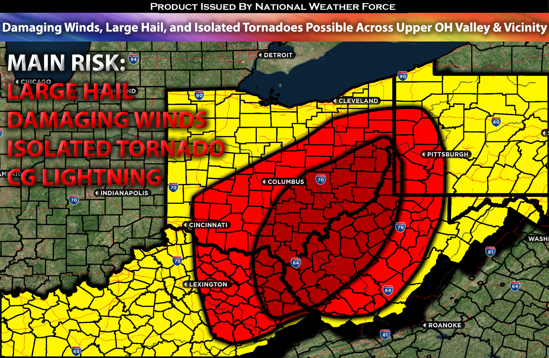
Outlook Across the Upper Ohio Valley and Appalachians:
Severe storms are possible, with the risk of scattered damaging winds, isolated large hail, and perhaps isolated tornadoes if conditions are right across the upper Ohio River Valley and parts of the Appalachians this afternoon. Please check below for further details on timing and impact.
Overall Forecast:
A surface low over the lower Mississippi Valley is projected to move northeastward quickly towards the Ohio Valley. Simultaneously, a surface cold front extending across southeast Louisiana will move east/northeast as the low intensifies, triggering thunderstorm development throughout the afternoon across the upper Ohio Valley.
This weather scenario is fueled by significant height falls and uplift in the left-exit region of a mid-level jet stream. A surge of mid-60s dewpoint moisture, accompanying the intensifying low, will usher a well-defined warm sector ahead of the cold front by early afternoon Thursday across parts of Kentucky, Ohio, and neighboring states, with a primary focus over eastern Ohio. Anticipated sufficient destabilization within the warm sector is expected to facilitate surface-based convection by Thursday afternoon. The interplay of strong synoptic-scale ascent and 50-knot deep-layer shear near the cold front is likely to result in a combination of discrete cells and clusters, including the potential for a few supercells. Increasing southeasterly winds at the lowest 1-2 km will enhance effective low-level shear, supporting both a tornado threat from the more robust/organized cells and a wind threat from the more organized systems. However, this situation is contingent on the convergence of all necessary conditions and the maturity of these storms, with the added complexity of a potential dry slot that could inhibit storm development.
Main Risk: damaging winds, large hail, isolated tornadoes (limited risk), and cloud-to-ground lightning.
Approximate Timing: Ongoing showers and storms are expected this morning across the upper Ohio Valley, including the vicinity. Then, as destabilization occurs, a cluster of stronger/severe storms is potentially anticipated to form ahead of the boundary around southeastern Ohio into West Virginia, moving northeast around the late afternoon into early evening hours before moving into neighboring states where there is a more stable air mass. These storms will be capable of producing scattered large hail, damaging winds, and perhaps isolated tornadoes if conditions are right.
Locations Impacted: central, southeast, and east Ohio; northwest and west West Virginia; western Pennsylvania; northeast and eastern Kentucky.
Stay tuned for more updates.
Sina⚡⚡
With over a decade of experience in forecasting severe thunderstorms, this individual is a seasoned forecaster and developer. Their expertise in severe weather forecasting and computer science is entirely self-taught, complemented by a foundation in Atmospheric Science from UNCO and an IT background from WGU. They have dedicated their efforts to developing innovative tools that enhance the accuracy of analyzing large hail and tornadoes. As a significant contributor and partner at National Weather Force Innovations LLC, they have played a crucial role in providing accurate and timely information. Additionally, they have been instrumental in developing tools and organizing projects that focus on accuracy and performance, ensuring those affected are well-informed.
