
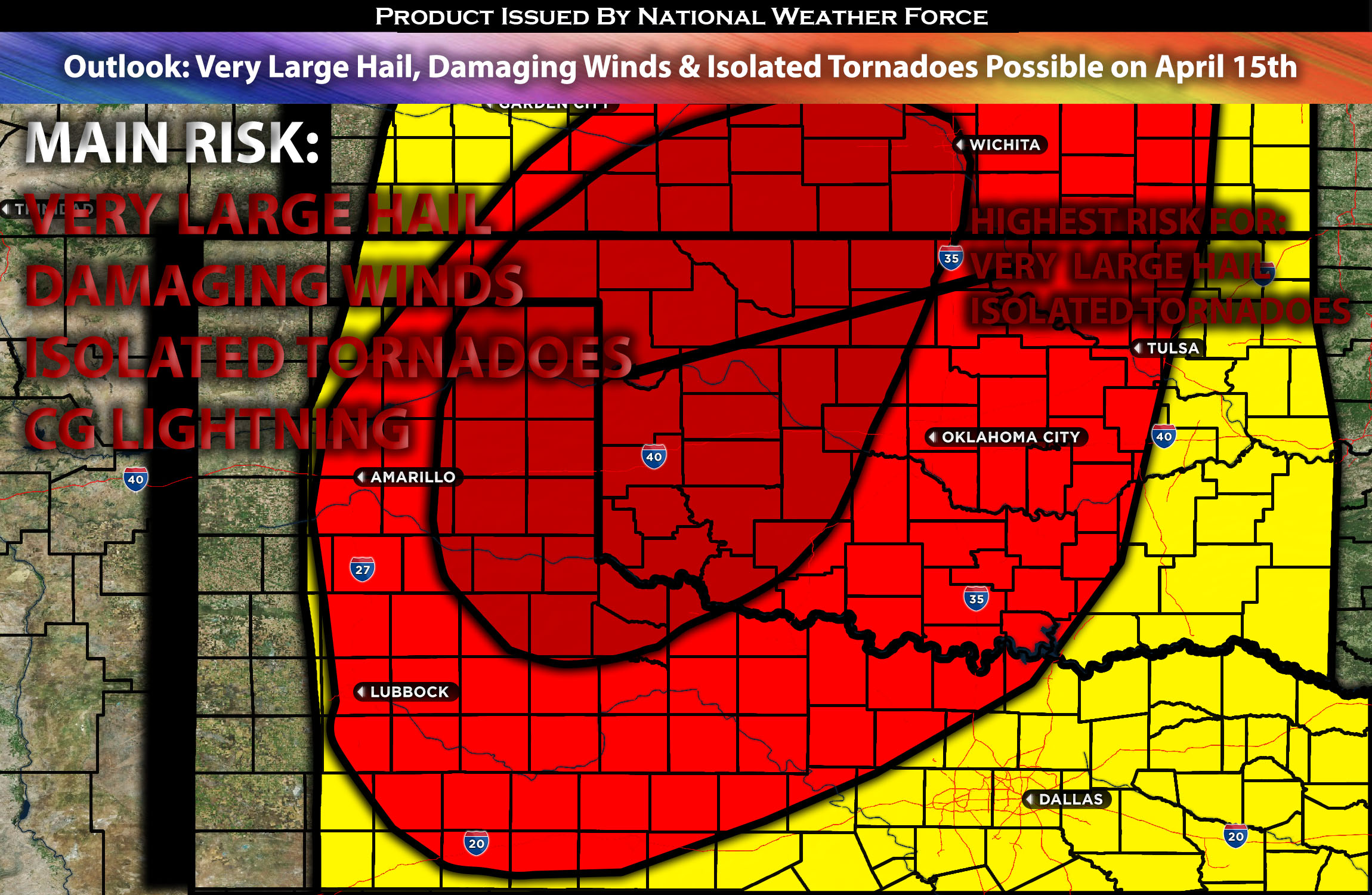
Outlook for the Central/Southern Plains :
Severe storms are more than likely across the southern to central Great Plains, mainly later Monday evening and night. Large to very large hail, damaging wind gusts, and a few tornadic storms are possible, with large hail being the main threat.
Preliminary Outlook:
By Monday afternoon, a negatively tilted shortwave trough within an embedded upper-level low is expected to be centered over the Rockies/Great Basin. Things are increasingly aligning with multiple embedded impulses moving eastward across the southern Rockies and Southwest, reaching the central to southern High Plains by early Tuesday morning. Particularly concentrated flow is anticipated further west, in the western Oklahoma/northern Texas area. The more vigorous southern impulse will continue to drive substantial amplification of the tropospheric flow as an intense mid-level jet develops across northwest Texas into southern Kansas on Monday night.
At the surface, a complex series of events is anticipated. Although low-level moisture from the northwest Gulf will be adequate for severe storms, it won’t be rich or deep enough to trigger a very large outbreak (anticipation). There is agreement that a plume of surface dew points in the low to mid 60s will advance ahead of the dryline, predominantly affecting the Panhandles, western Oklahoma and western North Texas. Widespread convective activity is expected to intensify Monday night, especially as the cold front merges with the dryline. Due to limited surface-based buoyancy it’s anticipated that initial supercells will form multiple smaller clusters rather than an extensive quasi-linear convective system. The primary threat will be large to very large hail, underpinned by steep mid-level lapse rates and supercell wind profiles. The tornado threat will mainly focus in areas where low-level moisture is more plentiful and a discrete supercell mode can be sustained, especially around northwest Texas and western Oklahoma. As the night progresses, one or two swaths of significant damaging wind potential may emerge as the atmospheric flow intensifies, although this potential will be constrained by weakening instability. Further things will continue to be monitored where the dry line will be positioned and how deep the moisture can get.
Potential risk: very large hail, damaging straight-line winds, isolated tornadoes and CG (cloud-ground) lightning.
Stay tuned for the next update, which will provide timing details, more specific information on impacted locations, and threats for specific micro-zones in the coming day.
Sina⚡⚡
With over a decade of experience in forecasting severe thunderstorms, this individual is a seasoned forecaster and developer. Their expertise in severe weather forecasting and computer science is entirely self-taught, complemented by a foundation in Atmospheric Science from UNCO and an IT background from WGU. They have dedicated their efforts to developing innovative tools that enhance the accuracy of analyzing large hail and tornadoes. As a significant contributor and partner at National Weather Force Innovations LLC, they have played a crucial role in providing accurate and timely information. Additionally, they have been instrumental in developing tools and organizing projects that focus on accuracy and performance, ensuring those affected are well-informed.