
 Outlook Across the Upper Ohio Valley and Appalachians:
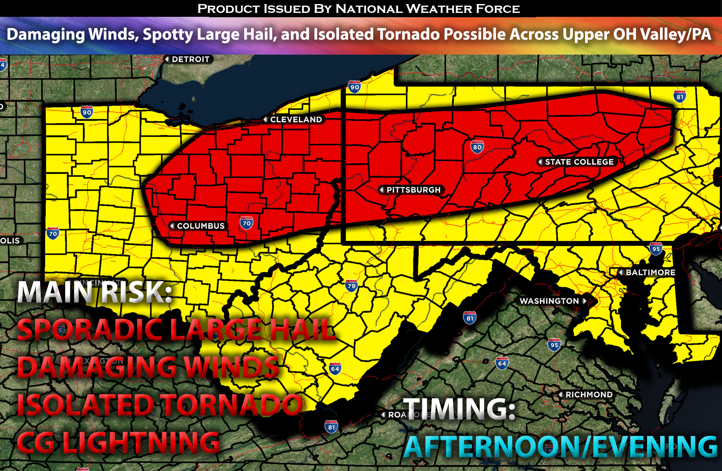
Scattered severe storms are expected from late afternoon into the evening on Sunday, for the Upper Ohio Valley through the Appalachians. The primary threat from these storms will be damaging winds, spotty large hail, and perhaps an isolated tornado.
Overall Forecast:
A mid-level closed low, initially centered over the West Coast, is expected to move eastward across the Great Basin on Sunday, while downstream ridging continues over the Plains and central U.S. Further east, west-northwesterly flow aloft will dominate, with a strong 80 kt speed vortex across the Great Lakes and Northeastern states. Concurrently, a short-wave trough associated with the mid-level jet is forecast to move across the Upper Ohio Valley and central Appalachians during the late afternoon and evening.
At the surface, a weak frontal low initially situated over the Michigan area is expected to move quickly eastward to western New England by the evening. Meanwhile, a trailing cold front will move southward across the southern Great Lakes region, extending into the central Appalachians and Midwest states throughout the afternoon and evening, and reaching the Ohio Valley overnight. This scenario, combined with steep mid-level lapse rates (a change in temperature with height), elevated instability across the warm sector ahead of the boundary, and efficient moisture transport, will facilitate the quick formation and maturation of storms into severe ones capable of producing large hail, damaging winds, and perhaps an isolated tornado (though limited by low-level shear). With heightened downward instability, damaging winds will be the primary risk factor with this setup.
Main Risk: damaging winds, large hail, isolated tornadoes (limited risk), and cloud-to-ground lightning.
Approximate Timing: Depending on when destabilization occurs, storms are anticipated to form ahead of the front sometime in the afternoon and move southward into the evening across the impacted regions. These storms are expected to be capable of producing sporadic large hail, damaging winds, and perhaps an isolated tornado as they move southward.
Locations Impacted: central, southeast, and east Ohio; northwest and northern West Virginia; western, central and northern Pennsylvania; northeast and eastern Kentucky.
Stay tuned for more updates.
Sina⚡⚡
With over a decade of experience in forecasting severe thunderstorms, this individual is a seasoned forecaster and developer. Their expertise in severe weather forecasting and computer science is entirely self-taught, complemented by a foundation in Atmospheric Science from UNCO and an IT background from WGU. They have dedicated their efforts to developing innovative tools that enhance the accuracy of analyzing large hail and tornadoes. As a significant contributor and partner at National Weather Force Innovations LLC, they have played a crucial role in providing accurate and timely information. Additionally, they have been instrumental in developing tools and organizing projects that focus on accuracy and performance, ensuring those affected are well-informed.