
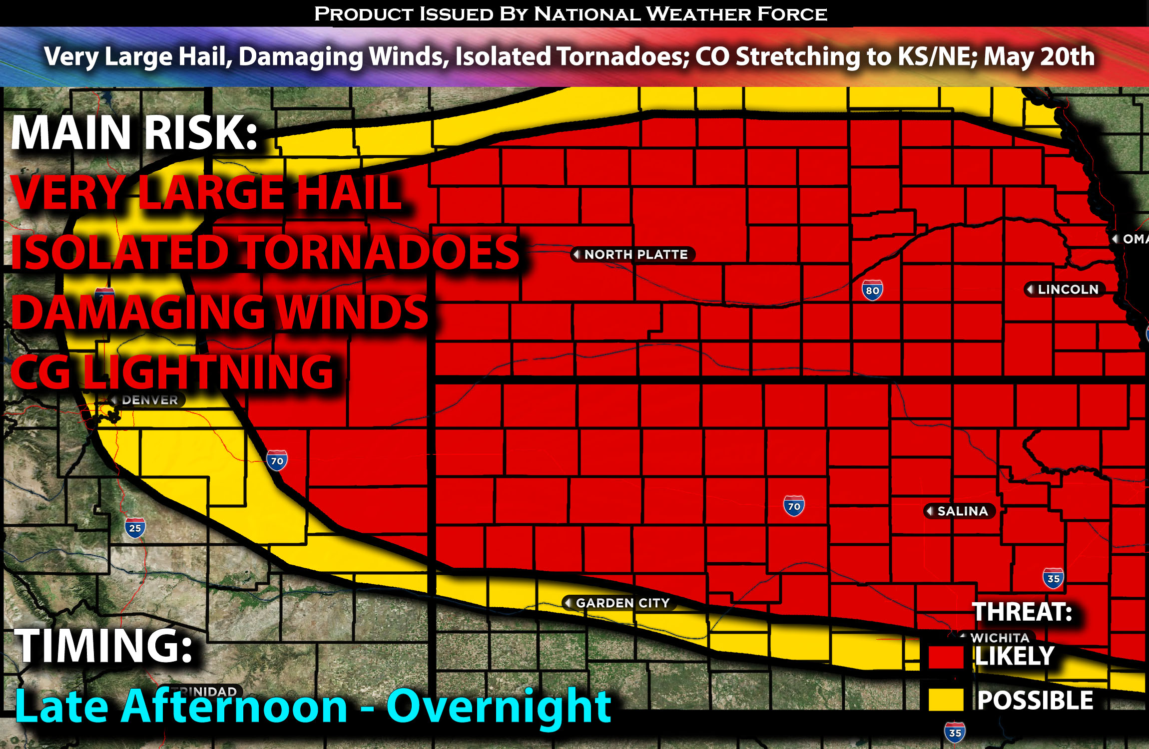
Outlook:
More severe storms are expected to form later Monday afternoon and continue into the evening hours and also across KS/NE into the overnight hours in clusters. These storms will be capable of producing all types of hazards including very large hail, damaging winds, and perhaps a few isolated tornadoes if given ingredients are present. For detailed information on timing, impacts, and more, refer below.
Overall Forecast:
After a widespread outbreak of wind damage from the very strong MCS that swept across the Plains, recovery will occur across Kansas with a northward flux of moisture and destabilization across the central Plains on Monday night. Unfortunately, this will set the stage for more severe weather given the present ingredients.
Across Northeastern CO Stretching to KS/NE Area:
Later Monday afternoon, increasingly favorable large-scale influences, combined with low-level upslope flow enhanced by surface cyclogenesis across southeast Colorado, will likely contribute to increasing storm development. This will occur from the northern Colorado/southern Wyoming mountains and higher terrain toward the Front Range vicinity and especially the adjacent High Plains. As these storms move eastward, they will encounter an increasingly favorable thermodynamic environment, continuing to strengthen into the evening hours. Strong deep-layer shear combined with strong instability across efficient moisture will support supercells capable of producing very large hail and an isolated tornado risk. Additionally, clusters of storms are expected to persist overnight across Nebraska and Kansas, with the main risks being damaging winds and large hail.
Coverage Details:
As destabilization occurs later in the afternoon, storms are expected to form and mature quickly in the northern Colorado area. These storms will continue to intensify as they move eastward into the more dynamic environment. The storms will progress into western portions of Kansas and Nebraska, continuing as a cluster overnight and capable of producing all hazard types. They will move eastward and then northeastward, reaching central and eventually eastern Nebraska by the early morning hours.
Future Radar Scenario:
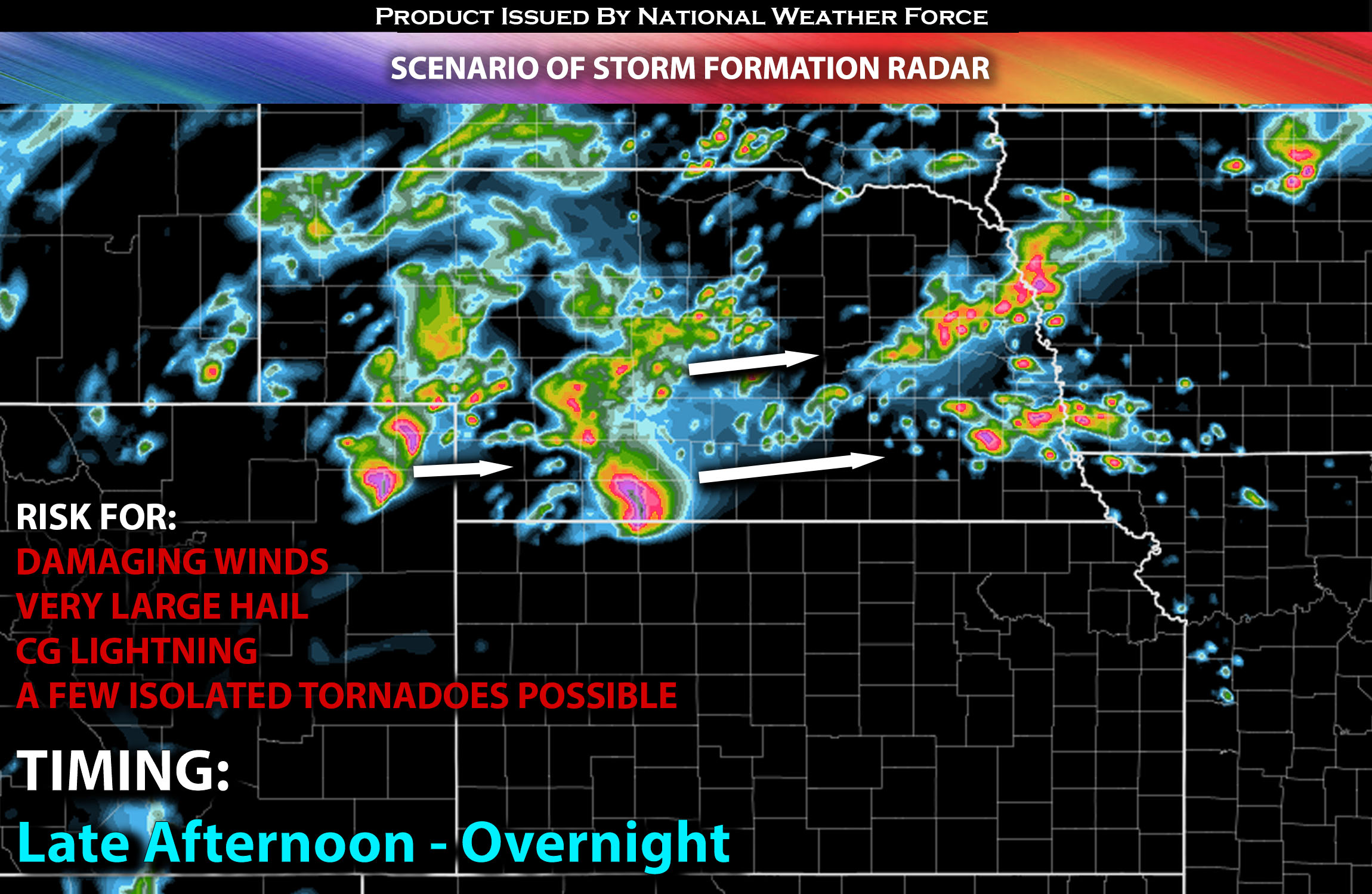
Main Risk: very large hail, damaging winds, a few isolated tornadoes possible (if ingredients align) and CG lightning (cloud to ground).
Stay tuned for more updates.
Sina⚡⚡
With over a decade of experience in forecasting severe thunderstorms, this individual is a seasoned forecaster and developer. Their expertise in severe weather forecasting and computer science is entirely self-taught, complemented by a foundation in Atmospheric Science from UNCO and an IT background from WGU. They have dedicated their efforts to developing innovative tools that enhance the accuracy of analyzing large hail and tornadoes. As a significant contributor and partner at National Weather Force Innovations LLC, they have played a crucial role in providing accurate and timely information. Additionally, they have been instrumental in developing tools and organizing projects that focus on accuracy and performance, ensuring those affected are well-informed.