
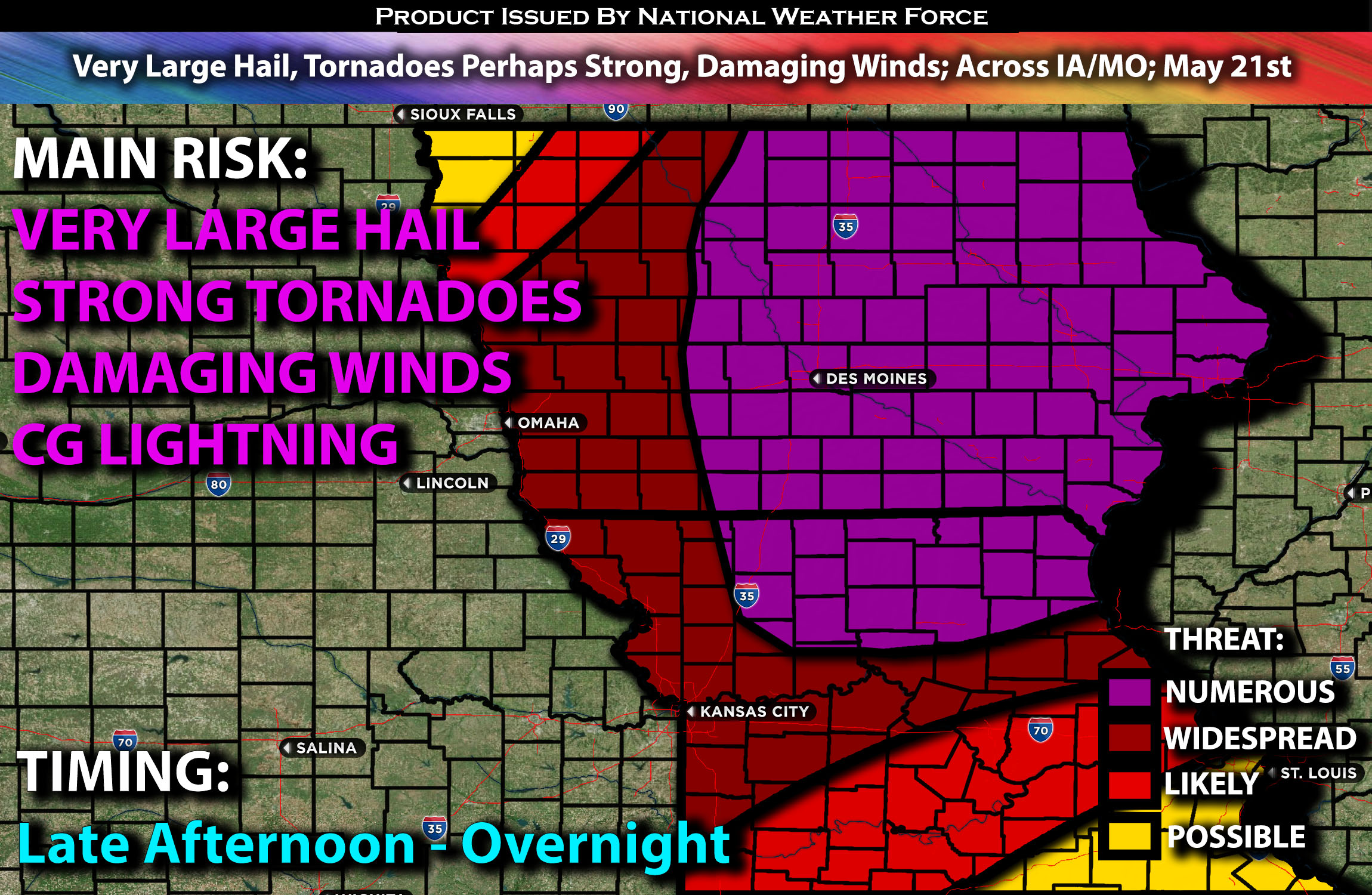
Outlook:
An extremely unstable airmass is expected to cover Iowa, stretching south into Missouri, on Tuesday late afternoon and into the evening, with a potential severe weather outbreak likely. These storms will be capable of producing very large hail, tornadoes (including the possibility of a few strong ones), and damaging winds. For detailed information on timing, impacts, and more, refer below.
Overall Forecast:
Across the mid-levels of the atmosphere, very strong curved westerly winds will extend from the south-central Great Plains to the Upper Midwest and Upper Great Lakes on Tuesday.
Portions of IA, Northern Central MO:
Simultaneously, a surface low will deepen and lift northeast to northern Wisconsin/Upper Michigan by the evening, with a surface warm front lifting northward ahead of the low. A cold front will surge east across Iowa and northern Missouri from mid-afternoon into the evening. Ahead of the cold front, deep warm air advection will combine with very steep mid-level lapse rates (temperature change with height), strong instability, deep layer effective shear, and a powerful low-level jet, leading to strong to very strong low-level shear, especially during the evening hours. These conditions will create a highly unstable airmass capable of producing large hail, tornadoes (potentially strong ones), and damaging winds, particularly after storms cluster later on.
Storm mode will initially be mostly discrete across Iowa and portions of north-central Missouri, allowing for super cellular formation and all hazard types, especially very large hail and the potential for strong tornadoes given the ingredients and the low-level shear. These storms will then transition into a QLCS, with the threat shifting to damaging winds and QLCS tornadoes as they move eastward.
Coverage Details:
As of this update, the remnants of an MCS are currently present across the Iowa area and will eventually continue eastward. The main risk will be limited to scattered hail and winds, but nothing significant. The atmosphere is then expected to recover very quickly, becoming extremely unstable. Storms are expected to develop rapidly in the late afternoon/evening hours and continue to strengthen, initially remaining discrete before becoming more linear, especially overnight. As a QLCS (a powerful line of storms) forms, this line will continue moving eastward overnight.
Future Radar Scenario:
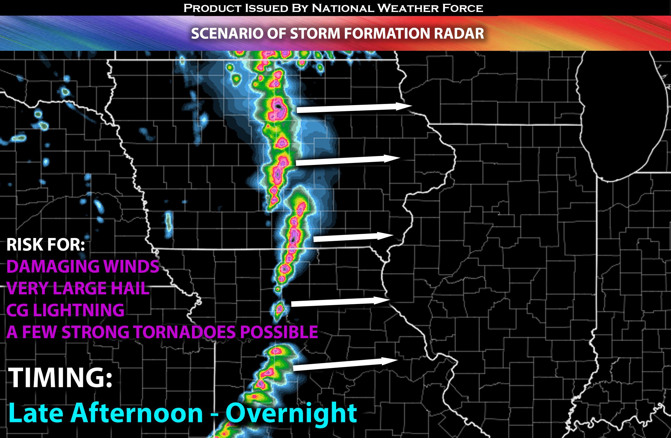
Main Risk: very large hail, damaging winds, tornadoes perhaps a few strong ones (if ingredients align) and CG lightning (cloud to ground).
Stay tuned for more updates.
Sina⚡⚡
With over a decade of experience in forecasting severe thunderstorms, this individual is a seasoned forecaster and developer. Their expertise in severe weather forecasting and computer science is entirely self-taught, complemented by a foundation in Atmospheric Science from UNCO and an IT background from WGU. They have dedicated their efforts to developing innovative tools that enhance the accuracy of analyzing large hail and tornadoes. As a significant contributor and partner at National Weather Force Innovations LLC, they have played a crucial role in providing accurate and timely information. Additionally, they have been instrumental in developing tools and organizing projects that focus on accuracy and performance, ensuring those affected are well-informed.