
 Outlook:
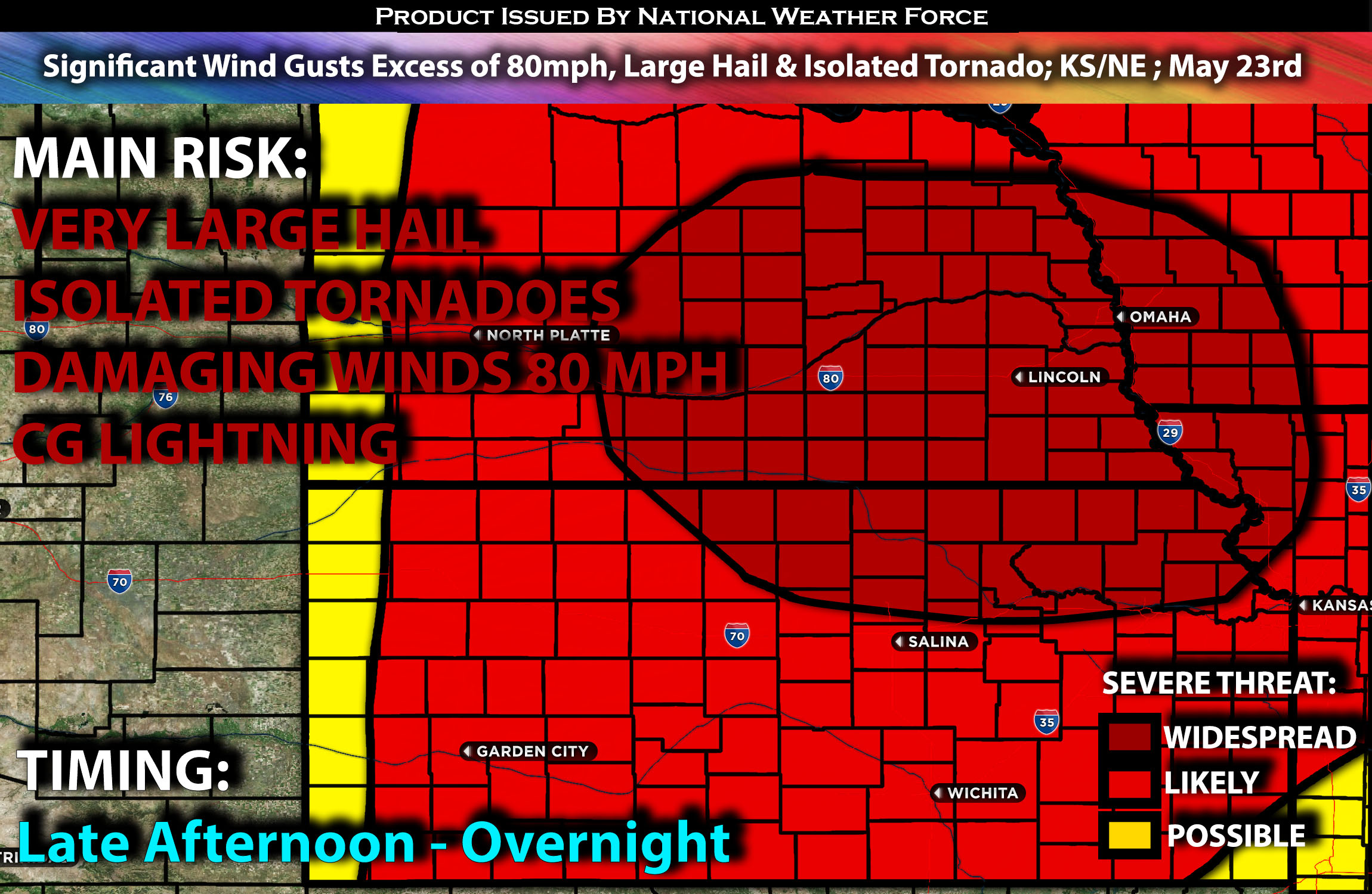
Severe storms are expected across much of Nebraska and Kansas, particularly in central and southeast Nebraska, but also impacting other parts of the region as they develop within an unstable airmass. These storms will be capable of producing all types of hazards, especially very large hail that could be locally destructive, damaging winds with significant gusts, from the late afternoon through the late evening hours and continuing overnight. For detailed information on timing, impacts, and more, refer below.
Overall Forecast:
In the mid and upper levels of the atmosphere, a trough is expected to move east across the northern Plains, with an embedded shortwave trough moving over the central Plains. At the surface, ahead of a developing cold front, a very unstable air mass will develop during the afternoon on Thursday. Mid-level lapse rates will be steep, with low-level moisture rapidly spreading north during the evening.
Across Portions of NE/KS & Vicinity:
Initial supercells are expected from west-central into central Nebraska, with cells also developing further south into Kansas. The initial threats will be very large hail, damaging winds, and isolated tornadoes. Eventually, these storms will organize into a severe MCS as they cluster and become more organized, lasting for many more hours as they move east. Significant wind gusts and hail will be possible, and some of these storms may also be capable of producing isolated tornadoes. These storms will continue moving southeastward and eventually reaching Omaha and NE neighboring states.
Some of these bowing storms will be capable of producing very damaging winds in excess of 80 mph, especially when the MCS is at its most intense.
Coverage Details:
As destabilization occurs in the late afternoon, storms will fire up quickly and cluster together rapidly, forming a line. At this point, there will be a risk of all hazard types. As an MCS forms and becomes more severe, it will bring the potential for very strong wind gusts that can cause significant damage, especially during the late evening and night hours across southern/southeastern Nebraska and northern Kansas.
Future Radar Scenario:
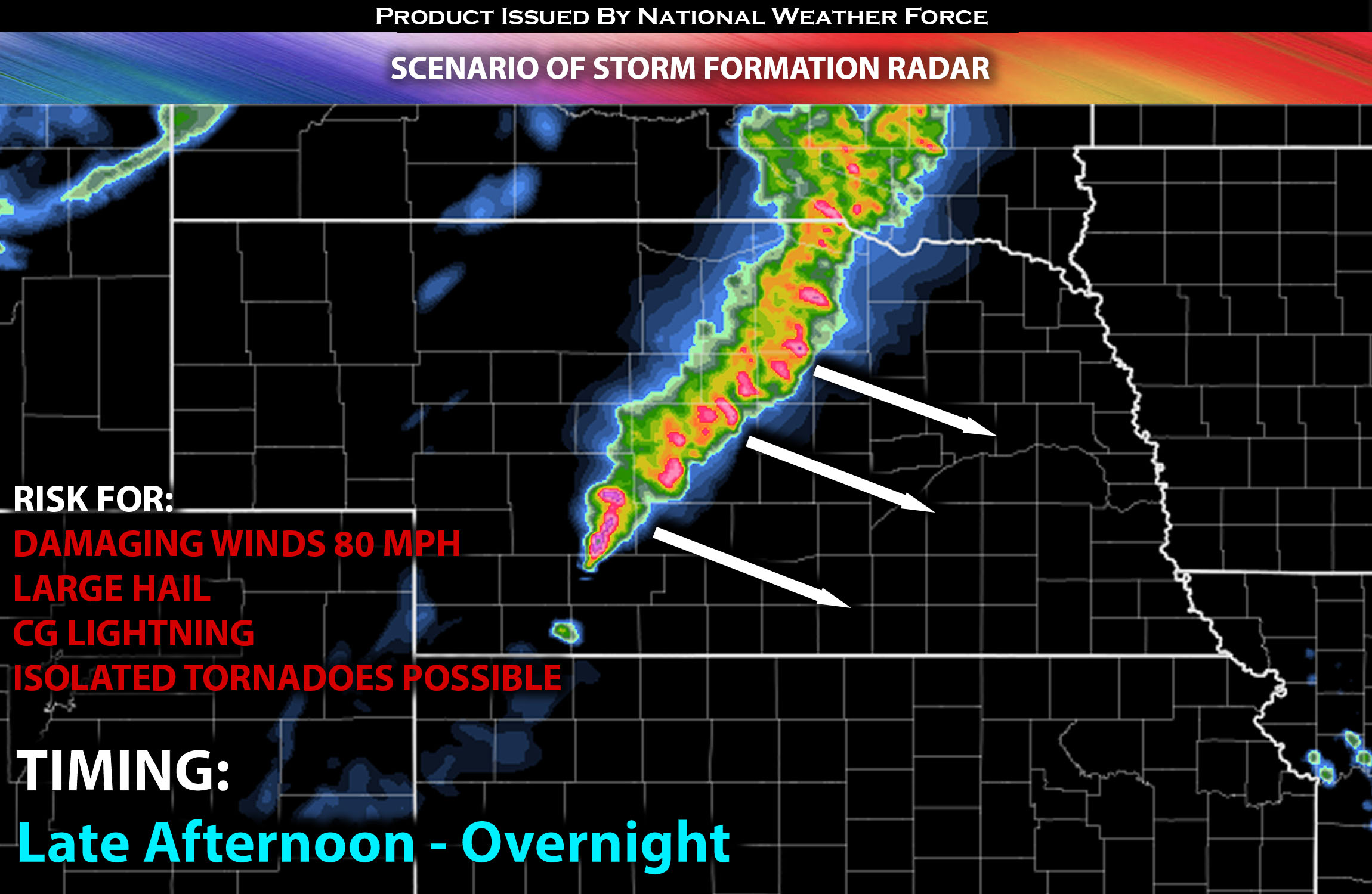 Main Risk: very large hail, damaging winds in excess of 80mph, isolated tornadoes (if ingredients align) and CG lightning (cloud to ground).
Stay tuned for more updates.
Sina⚡⚡
With over a decade of experience in forecasting severe thunderstorms, this individual is a seasoned forecaster and developer. Their expertise in severe weather forecasting and computer science is entirely self-taught, complemented by a foundation in Atmospheric Science from UNCO and an IT background from WGU. They have dedicated their efforts to developing innovative tools that enhance the accuracy of analyzing large hail and tornadoes. As a significant contributor and partner at National Weather Force Innovations LLC, they have played a crucial role in providing accurate and timely information. Additionally, they have been instrumental in developing tools and organizing projects that focus on accuracy and performance, ensuring those affected are well-informed.