
 Outlook:
A pronounced outbreak is potentially likely if all ingredients align. These storms will be capable of being very violent, producing very large, sometimes destructive hail, and tornadoes with the potential for long-lived and violent ones across the central and portions of the southern Plains later this afternoon through the late evening hours, especially. For detailed information on timing, impacts, and more, refer below.
Overall Forecast:
An amplified mid-level trough, containing multiple embedded shortwave impulses to enhance lift, is expected to move into the central and southern High Plains. Surface temperatures west of the dryline will rise significantly, leading to thunderstorm development across the southern and central Plains.
Across the Southern/Central Plains:
Deep boundary-layer moisture ahead of the dryline will be confined to western Oklahoma through the late afternoon, making this the most concentrated area for long-lived supercells. A more well-mixed boundary layer is expected further north in western and central Kansas, while the rich moisture in central Oklahoma should deepen later. Given the extreme instability combined with very strong to extreme shear at all atmospheric levels, and very strong low-level shear, storms will be capable of producing very large hail and isolated severe wind gusts in the afternoon. The relatively elongated/straight hodographs will support the potential for left- and right-splitting supercells.
A strengthening low-level jet will significantly increase the tornado threat by early evening. The most volatile environment for long-lived, intense tornadic supercells should exist over the western half into central Oklahoma. A few tornadoes might be violent, intense, and long-lived, given the ingredients present, with an outbreak potentially possible, especially during the evening hours should this scenario unfold. There is the slight uncertainty of storms also forming earlier than anticipated which could change the risk overall for tornadoes.
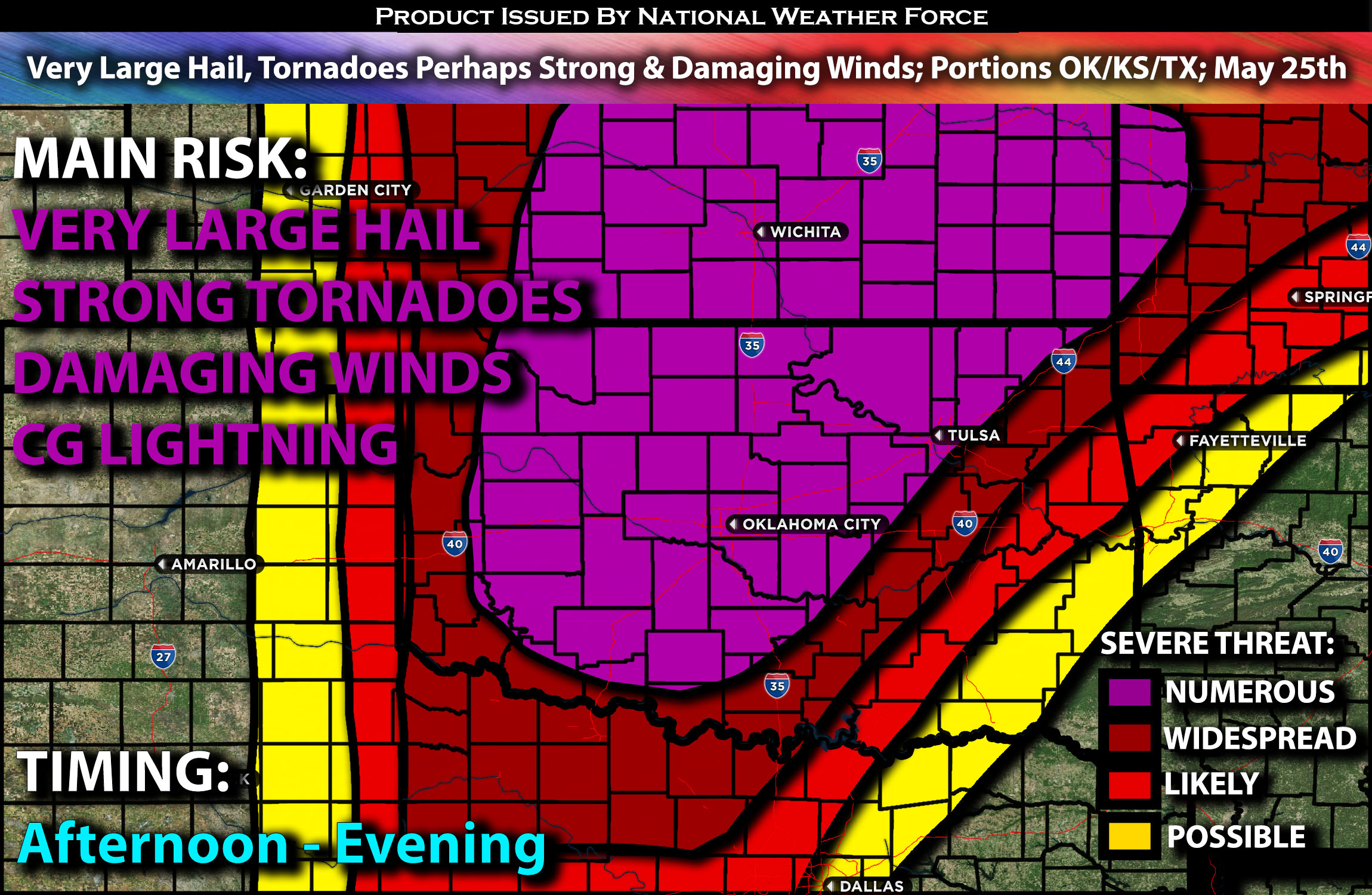
Coverage Details:
Destabilization is anticipated to occur sometime between the early and late afternoon due to the unstable air mass across the region. These storms are expected to quickly strengthen, staying discrete and capable of all hazard types from western and central Oklahoma into portions of northern Texas and the Dallas region. The main risks for these storms will be very large, locally destructive hail and tornadoes, especially during the evening hours. If the jet stream, which is anticipated to strengthen in the evening, aligns with this scenario, there is potential for a few violent, long-lived tornadoes through the late evening hours. Some weakening is anticipated as storms cluster overnight, but they will continue to pose a threat for very large hail and a few tornadoes.
Future Radar Scenario:
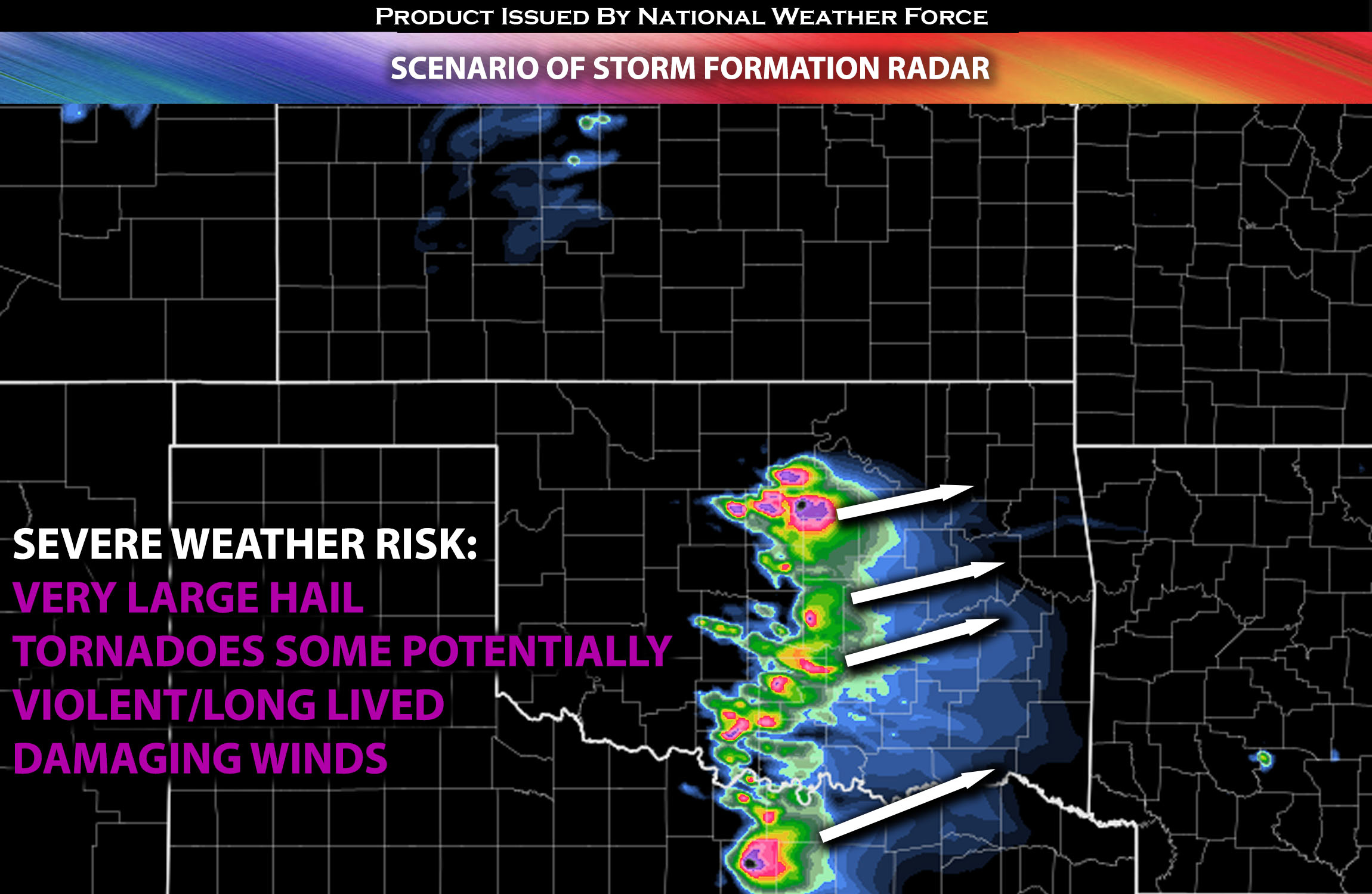
Main Risk: very large hail, tornadoes with the potential for violent/long lived tornadoes (if ingredients align), damaging winds and CG lightning (cloud to ground).
Stay tuned for more updates.
Sina⚡⚡
With over a decade of experience in forecasting severe thunderstorms, this individual is a seasoned forecaster and developer. Their expertise in severe weather forecasting and computer science is entirely self-taught, complemented by a foundation in Atmospheric Science from UNCO and an IT background from WGU. They have dedicated their efforts to developing innovative tools that enhance the accuracy of analyzing large hail and tornadoes. As a significant contributor and partner at National Weather Force Innovations LLC, they have played a crucial role in providing accurate and timely information. Additionally, they have been instrumental in developing tools and organizing projects that focus on accuracy and performance, ensuring those affected are well-informed.